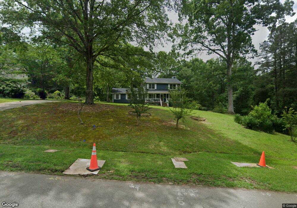
5945 Huddersfield Rd Macon, GA 31210
Estimated Value: $242,000 - $269,966
3
Beds
3
Baths
2,072
Sq Ft
$125/Sq Ft
Est. Value
About This Home
This home is located at 5945 Huddersfield Rd, Macon, GA 31210 and is currently estimated at $258,242, approximately $124 per square foot. 5945 Huddersfield Rd is a home located in Bibb County with nearby schools including Carter Elementary School, Howard Middle School, and Howard High School.
Ownership History
Date
Name
Owned For
Owner Type
Purchase Details
Closed on
Aug 26, 2010
Sold by
Byas Carl and Byas Annie L
Bought by
Byas Carl and Byas Annie L
Current Estimated Value
Home Financials for this Owner
Home Financials are based on the most recent Mortgage that was taken out on this home.
Original Mortgage
$235,500
Outstanding Balance
$154,920
Interest Rate
4.52%
Mortgage Type
Reverse Mortgage Home Equity Conversion Mortgage
Estimated Equity
$103,322
Purchase Details
Closed on
Apr 29, 1999
Bought by
Byas Carl and Byas Annie L
Create a Home Valuation Report for This Property
The Home Valuation Report is an in-depth analysis detailing your home's value as well as a comparison with similar homes in the area
Home Values in the Area
Average Home Value in this Area
Purchase History
| Date | Buyer | Sale Price | Title Company |
|---|---|---|---|
| Byas Carl | -- | None Available | |
| Byas Carl | $116,500 | -- |
Source: Public Records
Mortgage History
| Date | Status | Borrower | Loan Amount |
|---|---|---|---|
| Open | Byas Carl | $235,500 |
Source: Public Records
Tax History Compared to Growth
Tax History
| Year | Tax Paid | Tax Assessment Tax Assessment Total Assessment is a certain percentage of the fair market value that is determined by local assessors to be the total taxable value of land and additions on the property. | Land | Improvement |
|---|---|---|---|---|
| 2025 | $1,863 | $90,388 | $14,245 | $76,143 |
| 2024 | $1,928 | $90,388 | $14,245 | $76,143 |
| 2023 | $1,876 | $77,705 | $14,245 | $63,460 |
| 2022 | $1,982 | $71,152 | $10,500 | $60,652 |
| 2021 | $2,012 | $66,796 | $9,240 | $57,556 |
| 2020 | $1,765 | $59,319 | $8,400 | $50,919 |
| 2019 | $1,779 | $59,319 | $8,400 | $50,919 |
| 2018 | $2,240 | $48,258 | $8,400 | $39,858 |
| 2017 | $1,277 | $48,258 | $8,400 | $39,858 |
| 2016 | $1,169 | $48,258 | $8,400 | $39,858 |
| 2015 | $2,005 | $55,313 | $8,400 | $46,913 |
| 2014 | $778 | $62,015 | $8,400 | $53,615 |
Source: Public Records
Map
Nearby Homes
- 163 Broadleaf Dr
- 218 Matlock Ln
- 103 Howard Oaks Dr
- 200 Stone Edge Rd
- 107 N Wellington
- 105 N Wellington
- 155 Howard Oaks Dr
- 331 Marjane Dr
- 106 Trillium Terrace
- 131 Ashford Park
- 118 Ashford Park
- 103 Hanover Place
- 228 Lagrange Ct
- 311 Castlegate Rd
- 180 Autumn Trace Ct
- 110 Aston Hall
- 200 Autumn Trace Ct
- 157 Camden Trace
- 153 Camden Trace
- 5969 Huddersfield Rd
- 5931 Huddersfield Rd
- 5981 Huddersfield Rd
- 5956 Huddersfield Rd Unit 65
- 5956 Huddersfield Rd
- 5956 Huddersfield Rd Unit 243
- 5942 Huddersfield Rd
- 5727 Trowbridge Ln
- 5715 Trowbridge Ln
- 5921 Huddersfield Rd
- 5970 Huddersfield Rd
- 470 Stone Edge Rd
- 5928 Huddersfield Rd
- 490 Stone Edge Rd
- 5984 Huddersfield Rd
- 5701 Trowbridge Ln
- 5735 Trowbridge Ln
- 5895 Huddersfield Rd
- 5925 Huddersfield Rd
- 5998 Huddersfield Rd