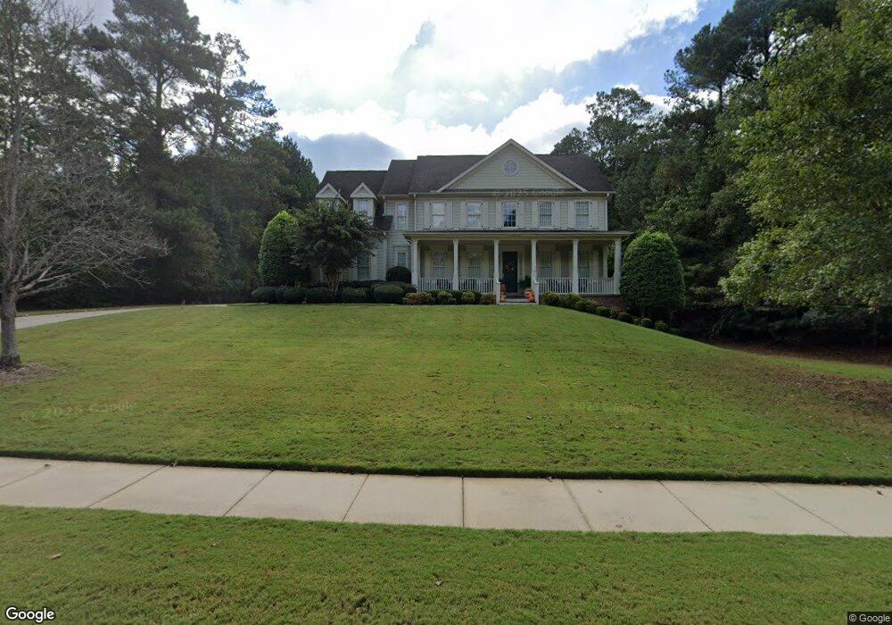
595 Mcdade St Tyrone, GA 30290
Estimated Value: $642,642 - $754,000
Studio
--
Bath
3,096
Sq Ft
$225/Sq Ft
Est. Value
About This Home
This home is located at 595 Mcdade St, Tyrone, GA 30290 and is currently estimated at $696,911, approximately $225 per square foot. 595 Mcdade St is a home located in Fayette County with nearby schools including Crabapple Lane Elementary School, Flat Rock Middle School, and Sandy Creek High School.
Ownership History
Date
Name
Owned For
Owner Type
Purchase Details
Closed on
Nov 2, 2004
Sold by
Kenny Johnson Homes Inc
Bought by
Weaver Michael D and Weaver Suzette
Current Estimated Value
Home Financials for this Owner
Home Financials are based on the most recent Mortgage that was taken out on this home.
Original Mortgage
$62,800
Interest Rate
6.3%
Mortgage Type
New Conventional
Purchase Details
Closed on
Sep 24, 2003
Sold by
Lake Windsong Development Co Llc
Bought by
Kenny Johnson Hms Inc
Home Financials for this Owner
Home Financials are based on the most recent Mortgage that was taken out on this home.
Original Mortgage
$300,300
Interest Rate
6.28%
Create a Home Valuation Report for This Property
The Home Valuation Report is an in-depth analysis detailing your home's value as well as a comparison with similar homes in the area
Home Values in the Area
Average Home Value in this Area
Purchase History
| Date | Buyer | Sale Price | Title Company |
|---|---|---|---|
| Weaver Michael D | $419,000 | -- | |
| Kenny Johnson Hms Inc | $56,000 | -- |
Source: Public Records
Mortgage History
| Date | Status | Borrower | Loan Amount |
|---|---|---|---|
| Closed | Weaver Michael D | $62,800 | |
| Open | Weaver Michael D | $335,100 | |
| Previous Owner | Kenny Johnson Hms Inc | $300,300 |
Source: Public Records
Tax History
| Year | Tax Paid | Tax Assessment Tax Assessment Total Assessment is a certain percentage of the fair market value that is determined by local assessors to be the total taxable value of land and additions on the property. | Land | Improvement |
|---|---|---|---|---|
| 2025 | $2,798 | $284,222 | $44,940 | $239,282 |
| 2024 | $2,733 | $265,628 | $42,000 | $223,628 |
| 2023 | $2,563 | $254,720 | $42,000 | $212,720 |
| 2022 | $2,342 | $222,480 | $42,000 | $180,480 |
| 2021 | $1,996 | $190,880 | $30,000 | $160,880 |
| 2020 | $1,916 | $179,440 | $30,000 | $149,440 |
| 2019 | $1,892 | $175,400 | $30,000 | $145,400 |
| 2018 | $1,789 | $166,040 | $30,000 | $136,040 |
| 2017 | $1,815 | $166,760 | $30,000 | $136,760 |
| 2016 | $1,643 | $146,120 | $22,800 | $123,320 |
| 2015 | $1,978 | $170,760 | $22,800 | $147,960 |
| 2014 | $1,769 | $147,320 | $22,800 | $124,520 |
| 2013 | -- | $143,120 | $0 | $0 |
Source: Public Records
Map
Nearby Homes
- 130 Windchime Way Unit 9
- 150 Kylemore Pass
- 100 Clydesdale Ct
- 135 Arabian
- 108 Tullamore Trail
- 121 Northwoods Rd
- 200 Chaparral Trace
- 80 Northwoods Rd
- 28 Border Point
- 235 Ashmere Ct
- 100 Leisure Trail
- 113 Creggan Hill Ct
- 321 Cottonwood Cir
- 152 Ardenlee Dr
- 1103 Maybeck Way
- 134 Ardenlee Dr
- 535 Laurelwood Dr
- 135 French Village Blvd
- 105 Laurel Forest Dr
- 308 Dalston Way
- 593 Mcdade St
- 597 Mcdade St
- 598 Mcdade St
- 599 Mcdade St
- 591 Mcdade St
- 401 Wicklow St
- 906 Dogwood Trail Unit 45
- 906 Dogwood Trail
- 365 Ashland Trail
- 402 Wicklow St Unit 64
- 402 Wicklow St
- 904 Dogwood Trail
- 102 Kenmare Row
- 589 Mcdade St
- 403 Wicklow St Unit 74
- 403 Wicklow St
- 909 Dogwood Trail
- 945 Mcdade St
- 945 Dogwood Trail
- 355 Ashland Trail
Your Personal Tour Guide
Ask me questions while you tour the home.