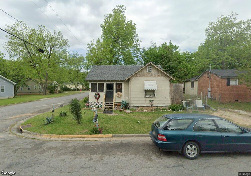
595 Melvin Place Macon, GA 31206
Estimated Value: $54,000 - $83,000
2
Beds
1
Bath
744
Sq Ft
$86/Sq Ft
Est. Value
About This Home
This home is located at 595 Melvin Place, Macon, GA 31206 and is currently estimated at $64,171, approximately $86 per square foot. 595 Melvin Place is a home located in Bibb County with nearby schools including Bruce Elementary School, Rutland Middle School, and Rutland High School.
Ownership History
Date
Name
Owned For
Owner Type
Purchase Details
Closed on
Jun 3, 2008
Sold by
Thomas Robert
Bought by
Ford Bernice
Current Estimated Value
Purchase Details
Closed on
Feb 16, 2007
Sold by
Ford Bernice V
Bought by
Thomas Robert
Home Financials for this Owner
Home Financials are based on the most recent Mortgage that was taken out on this home.
Original Mortgage
$33,880
Interest Rate
6.17%
Mortgage Type
Seller Take Back
Create a Home Valuation Report for This Property
The Home Valuation Report is an in-depth analysis detailing your home's value as well as a comparison with similar homes in the area
Home Values in the Area
Average Home Value in this Area
Purchase History
| Date | Buyer | Sale Price | Title Company |
|---|---|---|---|
| Ford Bernice | $33,880 | None Available | |
| Thomas Robert | $36,500 | None Available |
Source: Public Records
Mortgage History
| Date | Status | Borrower | Loan Amount |
|---|---|---|---|
| Previous Owner | Thomas Robert | $33,880 |
Source: Public Records
Tax History Compared to Growth
Tax History
| Year | Tax Paid | Tax Assessment Tax Assessment Total Assessment is a certain percentage of the fair market value that is determined by local assessors to be the total taxable value of land and additions on the property. | Land | Improvement |
|---|---|---|---|---|
| 2025 | $550 | $22,400 | $1,600 | $20,800 |
| 2024 | $569 | $22,400 | $1,600 | $20,800 |
| 2023 | $437 | $17,200 | $1,600 | $15,600 |
| 2022 | $559 | $16,151 | $1,742 | $14,409 |
| 2021 | $425 | $11,195 | $1,109 | $10,086 |
| 2020 | $382 | $9,833 | $1,188 | $8,645 |
| 2019 | $347 | $8,875 | $950 | $7,925 |
| 2018 | $963 | $10,052 | $950 | $9,102 |
| 2017 | $377 | $10,052 | $950 | $9,102 |
| 2016 | $348 | $10,053 | $950 | $9,102 |
| 2015 | $492 | $10,053 | $950 | $9,102 |
| 2014 | $613 | $10,880 | $950 | $9,930 |
Source: Public Records
Map
Nearby Homes
- 4249 Trammel Ave
- 4189 Marion Ave
- 4030 Marion Ave
- 4319 Worsham Ave
- 4298 Worsham Ave
- 4268 Marion Ave
- 4054 Marion Ave
- 4283 Irving Ave
- 4255 Worsham Ave
- 4305 Marion Ave
- 4062 Broadway
- 562 Richmond St
- 567 Richmond St
- 110 Debbie Ct
- 4235 Mikado Ave
- 4378 Mikado Ave
- 4386 Mikado Ave
- 3861 Desoto Dr
- 935 Troupe St
- 4067 Mikado Ave
- 4184 Roy Ave
- 656 Melvin Place
- 4180 Roy Ave
- 605 Melvin Place
- 0 Roy Ave Unit 9074347
- 588 Melvin Place
- 588 Melvin Place Unit A
- 580 Melvin Place
- 4181 Roy Ave
- 604 Melvin Place
- 621 Melvin Place
- 572 Melvin Place
- 553 Melvin Place
- 557 Melvin Place
- 4169 Roy Ave
- 616 Melvin Place
- 4212 Roy Ave
- 4185 Dorothy Ave
- 4211 Roy Ave
- 4218 Roy Ave