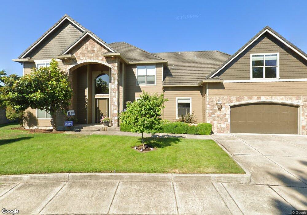
595 St Andrews Loop Creswell, OR 97426
Estimated Value: $795,000 - $1,028,000
4
Beds
3
Baths
3,531
Sq Ft
$257/Sq Ft
Est. Value
About This Home
This home is located at 595 St Andrews Loop, Creswell, OR 97426 and is currently estimated at $906,168, approximately $256 per square foot. 595 St Andrews Loop is a home located in Lane County with nearby schools including Creslane Elementary School, Creswell Middle School, and Creswell High School.
Ownership History
Date
Name
Owned For
Owner Type
Purchase Details
Closed on
Apr 6, 2007
Sold by
Winters Chere Brazel
Bought by
Scott Steven C and Scott Shauna M
Current Estimated Value
Purchase Details
Closed on
Nov 12, 2003
Sold by
Frontier Land Co Llc
Bought by
Winters Chere Brazel
Home Financials for this Owner
Home Financials are based on the most recent Mortgage that was taken out on this home.
Original Mortgage
$55,230
Interest Rate
5.89%
Mortgage Type
Purchase Money Mortgage
Create a Home Valuation Report for This Property
The Home Valuation Report is an in-depth analysis detailing your home's value as well as a comparison with similar homes in the area
Home Values in the Area
Average Home Value in this Area
Purchase History
| Date | Buyer | Sale Price | Title Company |
|---|---|---|---|
| Scott Steven C | $145,000 | Fidelity National Title Insu | |
| Winters Chere Brazel | $78,900 | Fidelity National Title Ins |
Source: Public Records
Mortgage History
| Date | Status | Borrower | Loan Amount |
|---|---|---|---|
| Previous Owner | Winters Chere Brazel | $55,230 |
Source: Public Records
Tax History Compared to Growth
Tax History
| Year | Tax Paid | Tax Assessment Tax Assessment Total Assessment is a certain percentage of the fair market value that is determined by local assessors to be the total taxable value of land and additions on the property. | Land | Improvement |
|---|---|---|---|---|
| 2025 | $9,355 | $568,866 | -- | -- |
| 2024 | $6,984 | $552,298 | -- | -- |
| 2023 | $6,984 | $536,212 | $0 | $0 |
| 2022 | $7,549 | $520,595 | $0 | $0 |
| 2021 | $7,294 | $505,433 | $0 | $0 |
| 2020 | $7,183 | $490,712 | $0 | $0 |
| 2019 | $7,025 | $476,420 | $0 | $0 |
| 2018 | $6,917 | $449,072 | $0 | $0 |
| 2017 | $6,709 | $449,072 | $0 | $0 |
| 2016 | $6,871 | $435,992 | $0 | $0 |
| 2015 | $6,624 | $423,293 | $0 | $0 |
| 2014 | $6,568 | $410,964 | $0 | $0 |
Source: Public Records
Map
Nearby Homes
- 375 Sunday Dr
- 685 St Andrews Loop
- 491 Ironwood Loop
- 336 Sunday Dr
- 316 Sunday Dr
- 370 Magnolia Dr
- 1765 Trevino Rd
- 700 N Mill St Unit 109
- 700 N Mill St
- 83354 N Pacific Hwy
- 689 Blue Jay Loop
- 0 River Dr
- 692 N 1st St
- 156 N 1st St
- 368 Hillegas Ave
- 589 Mary Neal Ln
- 0 Holbrook Ln Unit 339588620
- 33465 Irish Ln
- 521 S 7th St
- 1 Queens Ave Unit 1
- 601 St Andrews Loop
- 598 St Andrews Loop
- 527 Pebble Beach Dr
- 1242 Masters Ave
- 607 St Andrews Loop
- 608 St Andrews Loop
- 1248 Masters Ave
- 539 Pebble Beach Dr
- 688 St Andrews Loop
- 515 Pebble Beach Dr
- 613 St Andrews Loop
- 618 St Andrews Loop
- 678 St Andrews Loop
- 1229 Masters Ave
- 1254 Masters Ave
- 1235 Masters Ave
- 550 Pebble Beach Dr
- 1241 Masters Ave
- 555 Emerald Pkwy
- 538 Pebble Beach Dr