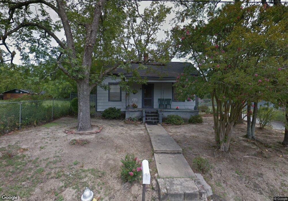
596 Mitchell St Macon, GA 31217
Fort Hill Historic District NeighborhoodEstimated Value: $47,374 - $78,000
Studio
1
Bath
896
Sq Ft
$67/Sq Ft
Est. Value
About This Home
This home is located at 596 Mitchell St, Macon, GA 31217 and is currently estimated at $59,844, approximately $66 per square foot. 596 Mitchell St is a home located in Bibb County with nearby schools including Burdell Elementary School, Appling Middle School, and Northeast High School.
Ownership History
Date
Name
Owned For
Owner Type
Purchase Details
Closed on
Dec 19, 2018
Sold by
Jackson Brandon K
Bought by
Fat Boy Entertainment Llc
Current Estimated Value
Purchase Details
Closed on
Jun 28, 2018
Sold by
Williams Cacheta Diontae
Bought by
Jackson Brandon K
Purchase Details
Closed on
Jan 18, 2018
Sold by
Harris Mary Lee
Bought by
Williams Cacheta Diontae
Purchase Details
Closed on
Apr 26, 1979
Sold by
Willie Mae Wesley Josephine Watson 1350
Bought by
Harris Mary Lee - Frank B
Create a Home Valuation Report for This Property
The Home Valuation Report is an in-depth analysis detailing your home's value as well as a comparison with similar homes in the area
Home Values in the Area
Average Home Value in this Area
Purchase History
| Date | Buyer | Sale Price | Title Company |
|---|---|---|---|
| Fat Boy Entertainment Llc | $6,500 | None Available | |
| Jackson Brandon K | $43,000 | None Available | |
| Williams Cacheta Diontae | -- | None Available | |
| Harris Mary Lee - Frank B | $4,500 | -- |
Source: Public Records
Tax History
| Year | Tax Paid | Tax Assessment Tax Assessment Total Assessment is a certain percentage of the fair market value that is determined by local assessors to be the total taxable value of land and additions on the property. | Land | Improvement |
|---|---|---|---|---|
| 2025 | $293 | $11,918 | $3,344 | $8,574 |
| 2024 | $248 | $9,756 | $2,040 | $7,716 |
| 2023 | $239 | $9,416 | $1,700 | $7,716 |
| 2022 | $225 | $6,512 | $2,138 | $4,374 |
| 2021 | $149 | $3,927 | $802 | $3,125 |
| 2020 | $140 | $3,614 | $802 | $2,812 |
| 2019 | $102 | $3,302 | $802 | $2,500 |
| 2018 | $375 | $3,258 | $802 | $2,456 |
| 2017 | $122 | $3,258 | $802 | $2,456 |
| 2016 | $113 | $3,258 | $802 | $2,456 |
| 2015 | $160 | $3,258 | $802 | $2,456 |
| 2014 | $74 | $3,925 | $855 | $3,070 |
Source: Public Records
Map
Nearby Homes
- 722 Mitchell St
- 990 Center St
- 1059 Fort Hill St
- 970 Center St
- 751 Mitchell St
- 873 Fort Hill St
- 856 Center St
- 808 Center St
- 658 Pringle St
- 760 Cowan St
- 725 Schaeffer Place
- 774 Maynard St
- 857 Mitchell St
- 972 Norris St
- 734 Fort Hill St
- 390 Cowan St
- 378 Cowan St
- 768 Maynard St
- 1392 Fort Hill St
- 690 Center St
- 608 Mitchell St
- 572 Mitchell St
- 1024 Womack St
- 1035 Womack St
- 1031 Chestney St
- 1039 Chestney St
- 558 Mitchell St
- 1051 Womack St
- 984 Womack St
- 1038 Mitchell Ln
- 1043 Chestney St
- 1038 Mitchell Ln
- 648 Mitchell St
- 1046 Mitchell Ln
- 565 Mitchell St
- 1046 Mitchell Ln
- 974 Womack St
- 1047 Chestney St
- 960 Womack St
- 536 Mitchell St
Your Personal Tour Guide
Ask me questions while you tour the home.