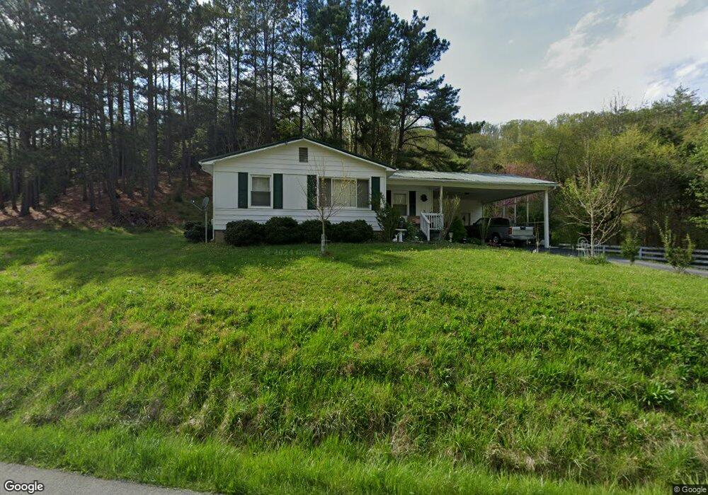
596 Oak Glen Cir Fall Branch, TN 37656
Estimated Value: $142,000 - $197,000
3
Beds
1
Bath
980
Sq Ft
$178/Sq Ft
Est. Value
About This Home
This home is located at 596 Oak Glen Cir, Fall Branch, TN 37656 and is currently estimated at $174,027, approximately $177 per square foot. 596 Oak Glen Cir is a home located in Washington County with nearby schools including Fall Branch Elementary School and Daniel Boone High School.
Ownership History
Date
Name
Owned For
Owner Type
Purchase Details
Closed on
Jul 15, 2011
Sold by
Sheperd Nicholas S
Bought by
Anderson Faye E
Current Estimated Value
Home Financials for this Owner
Home Financials are based on the most recent Mortgage that was taken out on this home.
Original Mortgage
$10,000
Outstanding Balance
$6,836
Interest Rate
4.53%
Mortgage Type
Commercial
Estimated Equity
$167,191
Purchase Details
Closed on
Jan 12, 2006
Sold by
Broyles Paul
Bought by
Sheperd Nicholas S
Home Financials for this Owner
Home Financials are based on the most recent Mortgage that was taken out on this home.
Original Mortgage
$45,400
Interest Rate
6.18%
Create a Home Valuation Report for This Property
The Home Valuation Report is an in-depth analysis detailing your home's value as well as a comparison with similar homes in the area
Purchase History
| Date | Buyer | Sale Price | Title Company |
|---|---|---|---|
| Anderson Faye E | $89,900 | -- | |
| Sheperd Nicholas S | $47,800 | -- |
Source: Public Records
Mortgage History
| Date | Status | Borrower | Loan Amount |
|---|---|---|---|
| Open | Anderson Faye E | $10,000 | |
| Open | Anderson Faye E | $82,400 | |
| Previous Owner | Sheperd Nicholas S | $45,400 |
Source: Public Records
Tax History
| Year | Tax Paid | Tax Assessment Tax Assessment Total Assessment is a certain percentage of the fair market value that is determined by local assessors to be the total taxable value of land and additions on the property. | Land | Improvement |
|---|---|---|---|---|
| 2025 | $589 | $35,225 | $2,575 | $32,650 |
| 2024 | $589 | $34,425 | $2,575 | $31,850 |
| 2022 | $422 | $19,650 | $2,350 | $17,300 |
| 2021 | $422 | $19,650 | $2,350 | $17,300 |
| 2020 | $422 | $19,650 | $2,350 | $17,300 |
| 2019 | $392 | $19,650 | $2,350 | $17,300 |
| 2018 | $392 | $16,475 | $2,350 | $14,125 |
| 2017 | $392 | $16,475 | $2,350 | $14,125 |
| 2016 | $392 | $16,475 | $2,350 | $14,125 |
| 2015 | $326 | $16,475 | $2,350 | $14,125 |
| 2014 | $326 | $16,475 | $2,350 | $14,125 |
Source: Public Records
Map
Nearby Homes
- 176 Moulton Rd
- 1340 Ryan Rd
- 211 Sunny Hill Ct
- 825 Old Blairs Gap Rd
- 901 Old Blairs Gap Rd
- 2145 Tennessee 93
- 963 Big Ridge Rd
- 255 Bank Dr
- 238 Cherry Ln
- TBD Tennessee 93
- 174 Double Springs Rd
- 3858 Beech Creek Rd
- 1500 Tucker Hollow Rd W
- 520 Highway 93
- 2710 Jearoldstown Rd
- Lots 3-4 Double Springs Rd
- Lot 1 Double Springs Rd
- Lot 2 Double Springs Rd
- 704 Church Hill Dr
- Tbd Jackson Cemetery Rd
- 601 Oak Glen Cir
- 605 Oak Glen Cir
- 134 Moulton Rd
- 569 Oak Glen Cir
- 630 Oak Glen Cir
- 127 Moulton Rd
- 149 Moulton Rd
- 652 Oak Glen Cir
- 654 Oak Glen Cir
- 178 Moulton Rd
- 530 Oak Glen Cir
- 221 Moulton Rd
- 512 Oak Glen Cir
- 662 Oak Glen Cir
- 515 Oak Glen Cir
- 676 Oak Glen Cir
- 237 Moulton Rd
- 489 Oak Glen Cir
- 486 Oak Glen Cir
- 688 Oak Glen Cir
Your Personal Tour Guide
Ask me questions while you tour the home.