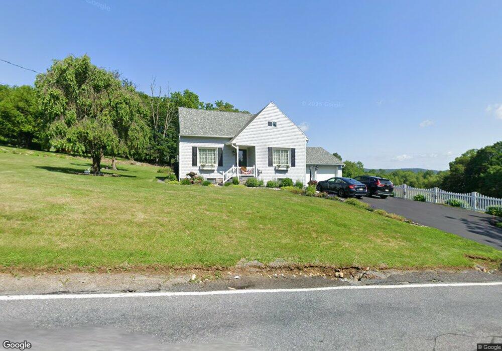
5964 Emmaus Rd Emmaus, PA 18049
Lower Milford NeighborhoodEstimated Value: $295,258 - $412,000
3
Beds
1
Bath
1,497
Sq Ft
$249/Sq Ft
Est. Value
About This Home
This home is located at 5964 Emmaus Rd, Emmaus, PA 18049 and is currently estimated at $373,315, approximately $249 per square foot. 5964 Emmaus Rd is a home located in Lehigh County with nearby schools including Southern Lehigh High School, St Ann Elementary School, and St. Michael the Archangel School.
Ownership History
Date
Name
Owned For
Owner Type
Purchase Details
Closed on
Nov 15, 2024
Sold by
Miller Philbur D and Miller Pamela J
Bought by
Miller Philbur D and Miller Pamela J
Current Estimated Value
Purchase Details
Closed on
Aug 6, 2001
Sold by
Miller Philbur E
Bought by
Miller Philbur D
Create a Home Valuation Report for This Property
The Home Valuation Report is an in-depth analysis detailing your home's value as well as a comparison with similar homes in the area
Home Values in the Area
Average Home Value in this Area
Purchase History
| Date | Buyer | Sale Price | Title Company |
|---|---|---|---|
| Miller Philbur D | -- | None Listed On Document | |
| Miller Philbur D | -- | None Listed On Document | |
| Miller Philbur D | -- | None Listed On Document | |
| Miller Philbur D | -- | -- | |
| Miller Philbur D | -- | -- |
Source: Public Records
Tax History Compared to Growth
Tax History
| Year | Tax Paid | Tax Assessment Tax Assessment Total Assessment is a certain percentage of the fair market value that is determined by local assessors to be the total taxable value of land and additions on the property. | Land | Improvement |
|---|---|---|---|---|
| 2025 | $4,363 | $197,800 | $65,200 | $132,600 |
| 2024 | $4,363 | $197,800 | $65,200 | $132,600 |
| 2023 | $4,363 | $197,800 | $65,200 | $132,600 |
| 2022 | $4,297 | $197,800 | $132,600 | $65,200 |
| 2021 | $4,200 | $197,800 | $65,200 | $132,600 |
| 2020 | $4,117 | $197,800 | $65,200 | $132,600 |
| 2019 | $4,050 | $197,800 | $65,200 | $132,600 |
| 2018 | $4,050 | $197,800 | $65,200 | $132,600 |
| 2017 | $4,011 | $197,800 | $65,200 | $132,600 |
| 2016 | -- | $197,800 | $65,200 | $132,600 |
| 2015 | -- | $197,800 | $65,200 | $132,600 |
| 2014 | -- | $197,800 | $65,200 | $132,600 |
Source: Public Records
Map
Nearby Homes
- 6173 Rizzuto Way Unit Lot 21
- 6175 Rizzuto Way
- 6175 Rizzuto Way Unit Lot 22
- 6173 LOT 21 Rizzuto Way
- 6469 Dekrane Dr Unit 2
- 6408 Dekrane Dr
- 5031 Hunter Ln
- 1500 Gable Dr
- 1622 Gable Dr
- 5869 Applebutter Hill Rd
- 5895 Glen Rd
- 2571 Brunner Rd
- 0 Glen Rd Unit 755784
- 2349 Edna Ave
- 7302 Leh St
- 7551 Clayton Ave
- 7338 Grant Rd
- 340 Chestnut Hill Rd
- 6551 Blue Church Rd S
- 5572 Northwood Dr
- 5949 Emmaus Rd
- 5961 Emmaus Rd
- 5953 Emmaus Rd
- 5995 Emmaus Rd
- 5931 Emmaus Rd
- 1385 Limeport Pike
- 1411 Limeport Pike
- 1429 Limeport Pike
- 5917 Emmaus Rd
- 5978 Emmaus Rd
- 1439 Limeport Pike
- 1435 Limeport Pike
- 1412 Limeport Pike
- 1443 Limeport Pike
- 5901 Emmaus Rd
- 6630 Limeport Pike
- 1447 Limeport Pike
- 1430 Limeport Pike
- 1455 Limeport Pike
- 5885 Emmaus Rd