Estimated Value: $129,390 - $234,000
3
Beds
2
Baths
1,498
Sq Ft
$120/Sq Ft
Est. Value
About This Home
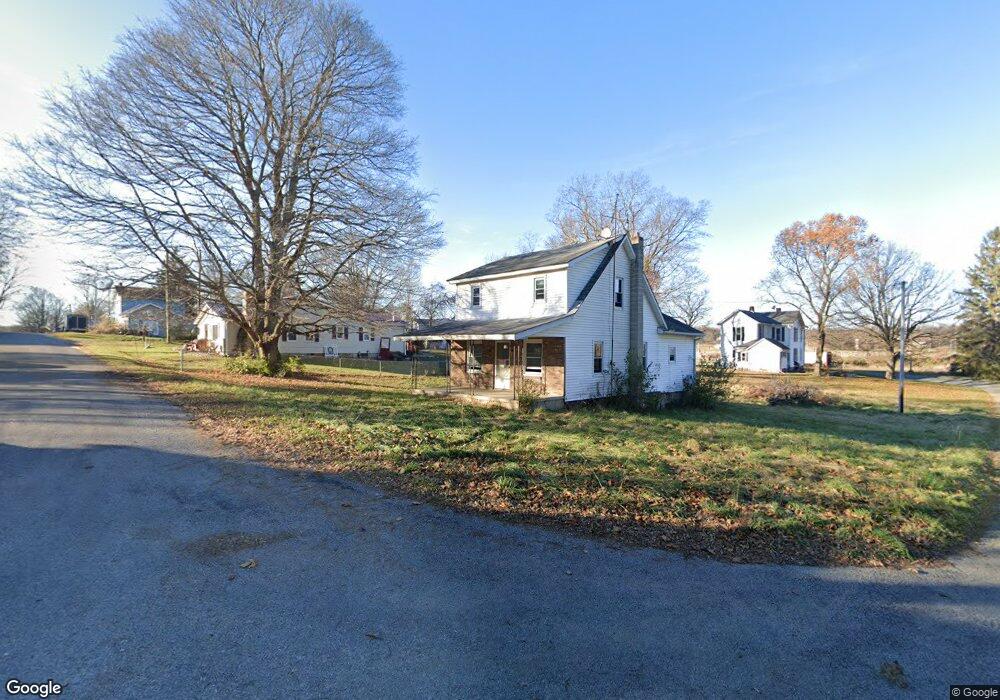
This home is located at 5984 Fillmore St, Cable, OH 43009 and is currently estimated at $179,848, approximately $120 per square foot. 5984 Fillmore St is a home with nearby schools including Triad Elementary School, Triad Middle School, and Triad High School.
Ownership History
Date
Name
Owned For
Owner Type
Purchase Details
Closed on
Dec 3, 2018
Sold by
Champaign County
Bought by
3 4 Aspirations Un Ltd
Current Estimated Value
Purchase Details
Closed on
Nov 22, 1999
Sold by
Leader Mortgage Co
Bought by
Butler Charles T
Home Financials for this Owner
Home Financials are based on the most recent Mortgage that was taken out on this home.
Original Mortgage
$58,710
Interest Rate
7.88%
Mortgage Type
VA
Purchase Details
Closed on
Aug 19, 1999
Sold by
Shrf Ronald L Hess Pr
Bought by
Leader Mortgage Co
Purchase Details
Closed on
Sep 21, 1995
Sold by
Moore Bert
Bought by
Hess Ronald L
Home Financials for this Owner
Home Financials are based on the most recent Mortgage that was taken out on this home.
Original Mortgage
$57,500
Interest Rate
7.78%
Mortgage Type
New Conventional
Create a Home Valuation Report for This Property
The Home Valuation Report is an in-depth analysis detailing your home's value as well as a comparison with similar homes in the area
Purchase History
| Date | Buyer | Sale Price | Title Company |
|---|---|---|---|
| 3 4 Aspirations Un Ltd | $2,200 | None Available | |
| Butler Charles T | $57,000 | -- | |
| Leader Mortgage Co | $59,900 | -- | |
| Hess Ronald L | $54,400 | -- |
Source: Public Records
Mortgage History
| Date | Status | Borrower | Loan Amount |
|---|---|---|---|
| Previous Owner | Butler Charles T | $58,710 | |
| Previous Owner | Hess Ronald L | $57,500 |
Source: Public Records
Tax History
| Year | Tax Paid | Tax Assessment Tax Assessment Total Assessment is a certain percentage of the fair market value that is determined by local assessors to be the total taxable value of land and additions on the property. | Land | Improvement |
|---|---|---|---|---|
| 2024 | $1,424 | $27,310 | $2,430 | $24,880 |
| 2023 | $1,100 | $27,310 | $2,430 | $24,880 |
| 2022 | $1,117 | $27,310 | $2,430 | $24,880 |
| 2021 | $971 | $21,840 | $1,940 | $19,900 |
| 2020 | $971 | $21,840 | $1,940 | $19,900 |
| 2019 | $958 | $21,840 | $1,940 | $19,900 |
| 2018 | $723 | $16,790 | $1,700 | $15,090 |
| 2017 | $687 | $16,790 | $1,700 | $15,090 |
| 2016 | $682 | $16,790 | $1,700 | $15,090 |
| 2015 | $681 | $16,070 | $1,700 | $14,370 |
| 2014 | $677 | $16,070 | $1,700 | $14,370 |
| 2013 | $640 | $16,070 | $1,700 | $14,370 |
Source: Public Records
Map
Nearby Homes
- 5886 Fillmore St
- 6683 Cable Rd
- 7521 Brush Lake Rd
- 5061 Cox Rd
- 0 Yocom Rd
- 6507 Spain St
- Lot 2 N Ludlow Rd
- 6704 Stevenson Rd
- 3314 Stone Quarry Rd
- 7181 Long Pond Rd
- 1992 Kennard Kingscreek Rd
- 10343 Urbana Woodstock Pike
- 28 Lloyd Dr
- 7588 Stringtown Rd
- 8389 Mingo Lewisburg Rd
- 8389 Mingo-Lewisburg Rd
- 41 E Townsend St
- 0 Lincoln Place Unit 226000852
- 0 Lincoln Place Unit 1044601
- 106 Cherry St
Your Personal Tour Guide
Ask me questions while you tour the home.