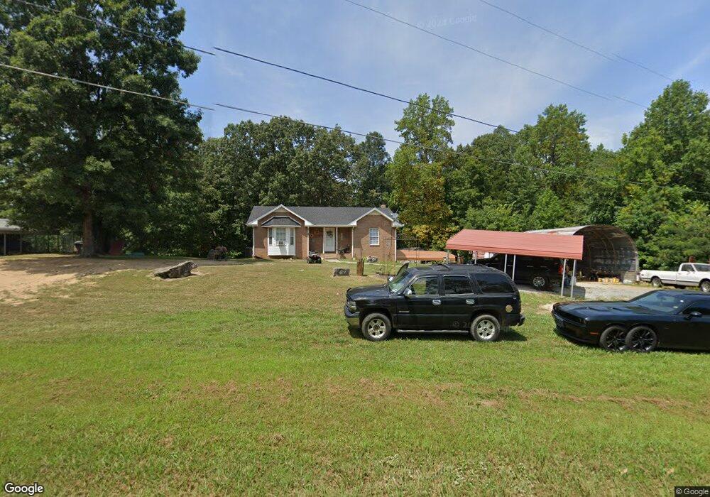
599 Bazzie Dock Rd Big Rock, TN 37023
Estimated Value: $223,000 - $288,000
--
Bed
2
Baths
1,284
Sq Ft
$195/Sq Ft
Est. Value
About This Home
This home is located at 599 Bazzie Dock Rd, Big Rock, TN 37023 and is currently estimated at $250,013, approximately $194 per square foot. 599 Bazzie Dock Rd is a home located in Stewart County with nearby schools including North Stewart Elementary School, Stewart County Middle School, and Stewart County High School.
Ownership History
Date
Name
Owned For
Owner Type
Purchase Details
Closed on
Nov 7, 2017
Sold by
Nixon John A
Bought by
Williams Charles Winston and Williams Carol Yvonne
Current Estimated Value
Purchase Details
Closed on
Feb 10, 2012
Sold by
Williams Carol
Bought by
Williams Charles Winston
Purchase Details
Closed on
Mar 9, 2010
Sold by
Cato Adrienna F
Bought by
Williams Charles W
Home Financials for this Owner
Home Financials are based on the most recent Mortgage that was taken out on this home.
Original Mortgage
$64,102
Interest Rate
5.5%
Mortgage Type
FHA
Purchase Details
Closed on
May 2, 1996
Bought by
Cato Adrienna F
Create a Home Valuation Report for This Property
The Home Valuation Report is an in-depth analysis detailing your home's value as well as a comparison with similar homes in the area
Home Values in the Area
Average Home Value in this Area
Purchase History
| Date | Buyer | Sale Price | Title Company |
|---|---|---|---|
| Williams Charles Winston | $90,000 | -- | |
| Williams Charles Winston | -- | -- | |
| Williams Charles W | $69,000 | -- | |
| Cato Adrienna F | $6,100 | -- |
Source: Public Records
Mortgage History
| Date | Status | Borrower | Loan Amount |
|---|---|---|---|
| Previous Owner | Cato Adrienna F | $64,102 |
Source: Public Records
Tax History Compared to Growth
Tax History
| Year | Tax Paid | Tax Assessment Tax Assessment Total Assessment is a certain percentage of the fair market value that is determined by local assessors to be the total taxable value of land and additions on the property. | Land | Improvement |
|---|---|---|---|---|
| 2024 | $854 | $57,475 | $5,200 | $52,275 |
| 2023 | $825 | $34,950 | $3,475 | $31,475 |
| 2022 | $771 | $32,675 | $3,475 | $29,200 |
| 2021 | $771 | $32,675 | $3,475 | $29,200 |
| 2020 | $791 | $32,675 | $3,475 | $29,200 |
| 2019 | $791 | $31,050 | $3,475 | $27,575 |
| 2018 | $791 | $31,050 | $3,475 | $27,575 |
| 2017 | $753 | $31,050 | $3,475 | $27,575 |
| 2016 | $753 | $29,550 | $3,225 | $26,325 |
| 2015 | $730 | $29,550 | $3,225 | $26,325 |
| 2014 | $762 | $29,550 | $3,225 | $26,325 |
| 2013 | $762 | $30,832 | $0 | $0 |
Source: Public Records
Map
Nearby Homes
- 242 Barn Circle Rd
- 376 Joiner Hollow Rd
- 2 Haleys Cove
- 1394 Highway 120
- 234 Bazzie Dock Rd
- 124 Norris Hancock Rd
- 2447 Highway 120
- 1551 Old Highway 79 Unit 1551
- 1077 Bumpus Mills Rd
- 124 Hayes Fork Creek Rd
- 223 Oak Tree Dr
- 909 Old Highway 79
- 416 Walker Ridge Rd
- 130 Wayne Threatt Rd
- 3023 Highway 120 Unit 3021
- 1 Highway 79
- 0 Stimson Rd Unit 24207833
- 0 Stimson Rd Unit RTC2944698
- 239 Wayne Threatt Rd
- 330 Durwachter Rd
- 607 Bazzie Dock Rd
- 591 Bazzie Dock Rd
- 584 Bazzie Dock Rd
- 608 Bazzie Dock Rd
- 111 Tosha Ln Unit 105
- 579 Bazzie Dock Rd Unit 573
- 630 Bazzie Dock Rd
- 573 Bazzie Dock Rd
- 574 Bazzie Dock Rd
- 705 Bazzie Dock Rd
- 707 Bazzie Dock Rd
- 706 Bazzie Dock Rd
- 711 Bazzie Dock Rd
- 567 Bazzie Dock Rd
- 552 Bazzie Dock Rd
- 727 Bazzie Dock Rd
- 533 Bazzie Dock Rd
- 153 Tosha Ln
- 550 Bazzie Dock Rd
- 538 Bazzie Dock Rd