599 Dt Vise Loop Parsons, TN 38363
Estimated payment $4,242/month
Highlights
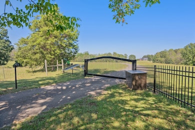
- Gated Parking
- Updated Kitchen
- Wooded Lot
- Decaturville Elementary School Rated A-
- 29.35 Acre Lot
- Vaulted Ceiling
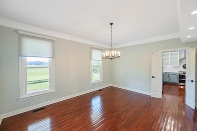
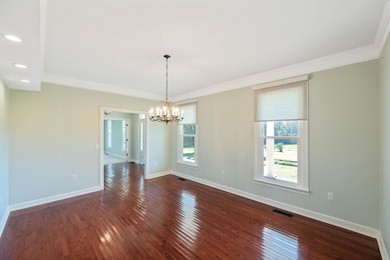
About This Home
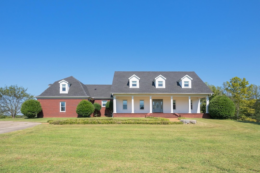
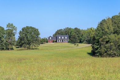
Private gated estate on 29± acres just outside Parsons city limits—no city taxes! Enjoy total seclusion with a solar keypad gated entrance, hilltop setting with breathtaking sunsets & abundant wildlife. Minutes from the TN River public marina & convenient to I-40. The home is over 4300 sq ft & features a new roof, windows, custom fabric shades, neutral paint throughout, quartz countertops, gas wifi oven/range, reverse osmosis water system, & a fully remodeled primary bath with garden tub & walk in tile shower. Multiple flex-use rooms offer versatile living options. Outdoors, you’ll find ~18 acres open pastureland, wooded areas, a new playground, & plenty of space for recreation, farming, or simply relaxing in nature. A built-in tornado shelter provides peace of mind. No neighbors in sight, minutes to town amenities. Recently appraised at $825,000—this rare property blends privacy, modern updates, & proximity to river life. Owner/Agent
Home Details
Home Type
- Single Family
Est. Annual Taxes
- $404
Year Built
- Built in 1997
Lot Details
- 29.35 Acre Lot
- Wrought Iron Fence
- Wooded Lot
Home Design
- Traditional Architecture
- Composition Shingle Roof
- Vinyl Siding
- Pier And Beam
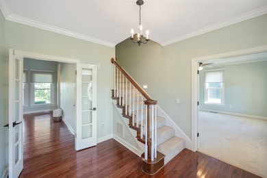
Interior Spaces
- 4,316 Sq Ft Home
- 2-Story Property
- Smooth Ceilings
- Vaulted Ceiling
- Ceiling Fan
- 1 Fireplace
- Double Pane Windows
- Two Story Entrance Foyer
- Separate Formal Living Room
- Dining Room
- Den
- Washer and Dryer Hookup
Kitchen
- Updated Kitchen
- Eat-In Kitchen
- Breakfast Bar
- Kitchen Island
Flooring
- Wood
- Partially Carpeted
- Tile
Bedrooms and Bathrooms
- 4 Bedrooms | 1 Primary Bedroom on Main
- Remodeled Bathroom
- Double Vanity
- Soaking Tub
- Bathtub With Separate Shower Stall
Home Security
- Security Gate
- Storm Doors
- Fire and Smoke Detector
- Termite Clearance
- Iron Doors
Parking
- 2 Car Garage
- Workshop in Garage
- Side Facing Garage
- Garage Door Opener
- Circular Driveway
- Gated Parking
Outdoor Features
- Separate Outdoor Workshop
- Outdoor Storage
- Porch
Utilities
- Multiple cooling system units
- Central Heating and Cooling System
- Electric Water Heater
- Septic Tank
Listing and Financial Details
- Assessor Parcel Number 038 014.07
Map
Home Values in the Area
Average Home Value in this Area
Tax History
| Year | Tax Paid | Tax Assessment Tax Assessment Total Assessment is a certain percentage of the fair market value that is determined by local assessors to be the total taxable value of land and additions on the property. | Land | Improvement |
|---|---|---|---|---|
| 2025 | $404 | $18,850 | $0 | $0 |
| 2024 | $404 | $15,675 | $15,675 | $0 |
| 2023 | $2,139 | $32,750 | $32,750 | $0 |
| 2022 | $2,139 | $82,925 | $20,100 | $62,825 |
| 2021 | $2,139 | $82,925 | $20,100 | $62,825 |
| 2020 | $2,139 | $82,925 | $20,100 | $62,825 |
| 2019 | $1,695 | $75,350 | $16,950 | $58,400 |
| 2018 | $1,499 | $75,350 | $16,950 | $58,400 |
| 2017 | $1,499 | $75,350 | $16,950 | $58,400 |
| 2016 | $1,499 | $75,350 | $16,950 | $58,400 |
| 2015 | $1,499 | $75,350 | $16,950 | $58,400 |
| 2014 | $1,500 | $75,356 | $0 | $0 |
Property History
| Date | Event | Price | List to Sale | Price per Sq Ft |
|---|---|---|---|---|
| 10/03/2025 10/03/25 | For Sale | $799,900 | -- | $185 / Sq Ft |
Purchase History
| Date | Type | Sale Price | Title Company |
|---|---|---|---|
| Warranty Deed | $575,000 | None Listed On Document | |
| Deed | -- | -- | |
| Deed | $90,000 | -- | |
| Warranty Deed | $76,000 | -- |
Mortgage History
| Date | Status | Loan Amount | Loan Type |
|---|---|---|---|
| Open | $190,000 | Construction |
Source: Memphis Area Association of REALTORS®
MLS Number: 10207001
APN: 038-014.02
Disclaimer: Certain information contained herein is derived from information provided by parties other than Homes.com. All information provided is deemed reliable, but is not guaranteed to be accurate and should be independently verified.
![]() IDX information is provided exclusively for personal, non-commercial use, and may not be used for any purpose other than to identify prospective properties consumers may be interested in purchasing.
IDX information is provided exclusively for personal, non-commercial use, and may not be used for any purpose other than to identify prospective properties consumers may be interested in purchasing.
Information is deemed reliable but not guaranteed.
Some or all of the listings displayed may not belong to the firm whose website is being visited. Copyright© 2025 Memphis Area Association of REALTORS®.
- 000 Poplar Ridge
- 0 Cub Creek Hall Rd
- 218 Captains Cove
- 00 Cub Creek Hall Rd
- 3080 Bible Hill Rd
- 0 Jeanette Holladay Rd
- 0 Brodies Landing Rd Unit RTC2772383
- Lot 140 Creek Ridge Cove
- 00 Brodies Landing Rd
- 0 River Spring Rd
- Jeannette Holladay Rd
- 0 Sulphur Spring Rd
- 398 Carrington Place
- Lot 141 Creek Ridge Cove
- 2642 Brodies Landing Rd
- lot 48 Berlin Rd
- 1124 Lick Creek Boat Dock Loop
- 0 Fisher Dr Unit RTC2431447
- 0 Fisher Dr Unit 10191214
