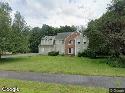
6 Bridle Path Shrewsbury, MA 01545
Outlying Shrewsbury NeighborhoodEstimated Value: $767,000 - $1,189,000
4
Beds
3
Baths
2,976
Sq Ft
$336/Sq Ft
Est. Value
About This Home
This home is located at 6 Bridle Path, Shrewsbury, MA 01545 and is currently estimated at $1,001,365, approximately $336 per square foot. 6 Bridle Path is a home located in Worcester County with nearby schools including Spring Street Elementary School, Sherwood Middle School, and Oak Middle School.
Ownership History
Date
Name
Owned For
Owner Type
Purchase Details
Closed on
Apr 19, 2005
Sold by
Emerson Homes Inc
Bought by
Jankowski Christine and Jankowski Edward
Current Estimated Value
Home Financials for this Owner
Home Financials are based on the most recent Mortgage that was taken out on this home.
Original Mortgage
$160,000
Outstanding Balance
$86,269
Interest Rate
5.78%
Mortgage Type
Purchase Money Mortgage
Estimated Equity
$969,733
Purchase Details
Closed on
Sep 25, 1996
Sold by
Raven Development Inc
Bought by
Jansson Brian S and Jansson Valerie
Purchase Details
Closed on
Feb 5, 1996
Sold by
Polito Dev Corp
Bought by
Raven Dev Inc
Create a Home Valuation Report for This Property
The Home Valuation Report is an in-depth analysis detailing your home's value as well as a comparison with similar homes in the area
Home Values in the Area
Average Home Value in this Area
Purchase History
| Date | Buyer | Sale Price | Title Company |
|---|---|---|---|
| Jankowski Christine | $403,900 | -- | |
| Jankowski Christine | $403,900 | -- | |
| Jankowski Christine | $403,900 | -- | |
| Jansson Brian S | $359,900 | -- | |
| Jansson Brian S | $359,900 | -- | |
| Raven Dev Inc | $85,000 | -- | |
| Raven Dev Inc | $85,000 | -- |
Source: Public Records
Mortgage History
| Date | Status | Borrower | Loan Amount |
|---|---|---|---|
| Open | Jankowski Christine | $160,000 | |
| Closed | Jankowski Christine | $160,000 | |
| Previous Owner | Jansson Brian S | $230,000 | |
| Previous Owner | Raven Dev Inc | $265,000 |
Source: Public Records
Tax History Compared to Growth
Tax History
| Year | Tax Paid | Tax Assessment Tax Assessment Total Assessment is a certain percentage of the fair market value that is determined by local assessors to be the total taxable value of land and additions on the property. | Land | Improvement |
|---|---|---|---|---|
| 2025 | $111 | $925,200 | $246,200 | $679,000 |
| 2024 | $11,258 | $909,400 | $234,400 | $675,000 |
| 2023 | $10,303 | $785,300 | $234,400 | $550,900 |
| 2022 | $11,071 | $784,600 | $326,200 | $458,400 |
| 2021 | $10,180 | $771,800 | $346,500 | $425,300 |
| 2020 | $9,689 | $777,000 | $346,500 | $430,500 |
| 2019 | $9,194 | $731,400 | $319,600 | $411,800 |
| 2018 | $9,214 | $727,800 | $307,400 | $420,400 |
| 2017 | $8,799 | $685,800 | $279,400 | $406,400 |
| 2016 | $8,811 | $677,800 | $263,100 | $414,700 |
| 2015 | $8,649 | $655,200 | $240,500 | $414,700 |
Source: Public Records
Map
Nearby Homes
- 70 Colonial Dr
- 1 Rams Gate Place
- 30 Bridle Path
- 29 Barnard Hill Rd
- 17 Perry Rd
- 11 Perry Rd
- 3 Sword St
- 3 Deerfield Rd
- 9 Morningside Dr
- 497 Church St
- 21 Morningside Dr
- 6 Birch Ln
- 116 Rocky Pond Rd
- 12 Red Coat Rd
- 8 Grist Mill Cir
- 19 Wachusett Cir
- 1 Kalamat Farms Cir
- 16 Bryant Ave
- 7 Venus Dr
- 162 Prospect St