L
Seller's Agent in 2016
Leslie Pearlson
Tea Lane Associates


Estimated Value: $4,347,000 - $6,414,000
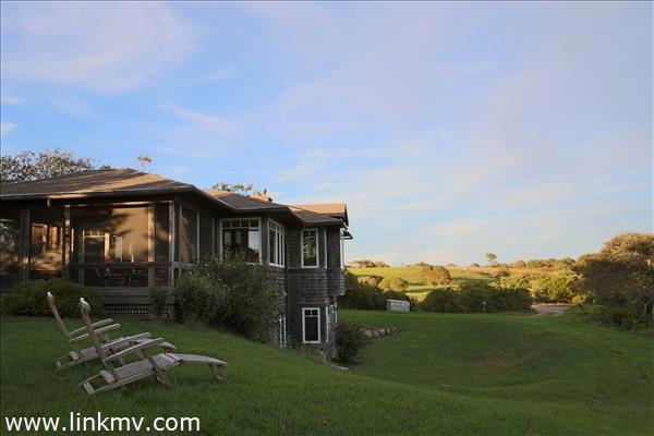
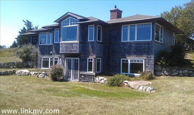
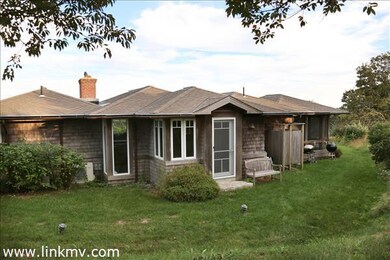
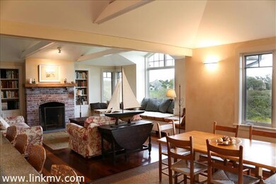
WALK TO LUCY VINCENT BEACH Find your own peaceful getaway in this light and airy home with protected 270 degree ocean views of Lucy Vincent Beach and the sweeping hills of the Allen Sheep Farm. Tucked off of pastoral Eddy Farm Road, you can see and hear the surf from the open plan kitchen, dining, and living room, as well as the master bedroom and screened porch. This unique home features granite counters, custom cabinets, antique doors, mahogany floors, and many other charming details. The lower level offers ocean and meadow views, a second sitting area, two bedrooms and second full bath. Make this welcoming spot your summer or year-round home... also has excellent rental history.
Last Agent to Sell the Property
Leslie Pearlson
Tea Lane Associates Listed on: 01/04/2016
Last Buyer's Agent
Leslie Pearlson
Tea Lane Associates Listed on: 01/04/2016
| Date | Buyer | Sale Price | Title Company |
|---|---|---|---|
| Slavin Paul A | $1,615,000 | -- |
| Date | Status | Borrower | Loan Amount |
|---|---|---|---|
| Open | Slavin Paul A | $1,130,500 |
| Date | Event | Price | List to Sale | Price per Sq Ft |
|---|---|---|---|---|
| 01/06/2016 01/06/16 | Sold | $1,615,000 | -10.0% | $808 / Sq Ft |
| 01/04/2016 01/04/16 | Pending | -- | -- | -- |
| 01/04/2016 01/04/16 | For Sale | $1,795,000 | -- | $898 / Sq Ft |
| Year | Tax Paid | Tax Assessment Tax Assessment Total Assessment is a certain percentage of the fair market value that is determined by local assessors to be the total taxable value of land and additions on the property. | Land | Improvement |
|---|---|---|---|---|
| 2025 | $12,767 | $5,674,300 | $3,176,300 | $2,498,000 |
| 2024 | $11,597 | $5,470,300 | $3,064,500 | $2,405,800 |
| 2023 | $10,297 | $3,915,300 | $2,037,000 | $1,878,300 |
| 2022 | $9,803 | $3,476,100 | $1,862,400 | $1,613,700 |
| 2021 | $9,439 | $3,243,500 | $1,862,400 | $1,381,100 |
| 2020 | $9,136 | $3,194,400 | $1,825,900 | $1,368,500 |
| 2019 | $7,055 | $2,449,600 | $1,825,900 | $623,700 |
| 2018 | $3,374 | $1,226,800 | $1,226,800 | $0 |
| 2017 | $4,098 | $1,529,000 | $1,226,800 | $302,200 |
| 2016 | $4,112 | $1,517,200 | $1,226,800 | $290,400 |
| 2015 | $3,999 | $1,520,600 | $1,226,800 | $293,800 |
| 2014 | $4,083 | $1,646,200 | $1,320,000 | $326,200 |
L
Seller's Agent in 2016
Leslie Pearlson
Tea Lane Associates
Source: LINK (Vineyard)
MLS Number: 29706
APN: CHIL-000025-000001-000002