
Seller's Agent in 2025
Derek Greene
The Greene Realty Group
(860) 560-1006
2 in this area
3,118 Total Sales
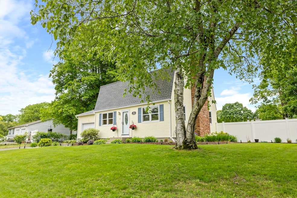
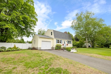
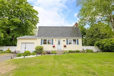
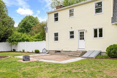

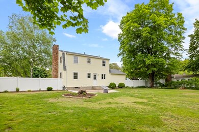
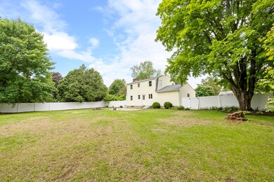
Best and final offers are to be submitted by Monday6/1 at 8pm. Charming home at 6 Hannum Brook in a quiet, friendly neighborhood just off West Street. The spacious backyard and mature front garden beds offer great outdoor space. The Hannum Brook Conservation Area is within walking distance for outdoor recreation. Inside, the large master bedroom (11x21) and open living room with a cozy fireplace create inviting & comfortable living spaces. The dining area is filled with natural light from large windows and doors. Recent updates include a new roof (2019), driveway (2020), modernized bathrooms, and fresh paint throughout. The HW heater was replaced in 2018. All flooring has been updated, and the home is move-in ready. Located under 2 miles from all schools, including Williston Northampton, this home is ideal for buyers seeking convenience and comfort. Don't miss this fantastic opportunity to own a beautifully maintained home in an extremely desirable neighborhood in Easthampton.
| Date | Type | Sale Price | Title Company |
|---|---|---|---|
| Quit Claim Deed | $450,000 | -- | |
| Quit Claim Deed | $450,000 | -- | |
| Deed | $120,000 | -- | |
| Deed | $120,000 | -- |
| Date | Status | Loan Amount | Loan Type |
|---|---|---|---|
| Previous Owner | $130,000 | No Value Available | |
| Previous Owner | $144,000 | No Value Available | |
| Previous Owner | $10,000 | No Value Available |
| Date | Event | Price | List to Sale | Price per Sq Ft |
|---|---|---|---|---|
| 06/27/2025 06/27/25 | Sold | $450,000 | +5.9% | $290 / Sq Ft |
| 06/05/2025 06/05/25 | Pending | -- | -- | -- |
| 05/28/2025 05/28/25 | For Sale | $425,000 | -- | $274 / Sq Ft |
| Year | Tax Paid | Tax Assessment Tax Assessment Total Assessment is a certain percentage of the fair market value that is determined by local assessors to be the total taxable value of land and additions on the property. | Land | Improvement |
|---|---|---|---|---|
| 2025 | $4,537 | $331,900 | $120,200 | $211,700 |
| 2024 | $4,374 | $322,600 | $116,700 | $205,900 |
| 2023 | $3,342 | $228,100 | $91,700 | $136,400 |
| 2022 | $3,770 | $228,100 | $91,700 | $136,400 |
| 2021 | $4,127 | $235,300 | $91,700 | $143,600 |
| 2020 | $4,051 | $228,100 | $91,700 | $136,400 |
| 2019 | $3,482 | $225,200 | $91,700 | $133,500 |
| 2018 | $3,629 | $226,800 | $86,500 | $140,300 |
| 2017 | $3,542 | $218,500 | $83,200 | $135,300 |
| 2016 | $3,406 | $218,500 | $83,200 | $135,300 |
| 2015 | $3,310 | $218,500 | $83,200 | $135,300 |
Seller's Agent in 2025
Derek Greene
The Greene Realty Group
(860) 560-1006
2 in this area
3,118 Total Sales
Buyer's Agent in 2025
Tracey Holden
Brick & Mortar
(413) 219-5083
1 in this area
32 Total Sales
Source: MLS Property Information Network (MLS PIN)
MLS Number: 73381456
APN: EHAM-000139-000156
Disclaimer: Certain information contained herein is derived from information provided by parties other than Homes.com. All information provided is deemed reliable, but is not guaranteed to be accurate and should be independently verified.
![]() The property listing data and information, or the Images, set forth herein were provided to MLS Property Information Network, Inc. from third party sources, including sellers, lessors and public records, and were compiled by MLS Property Information Network, Inc. The property listing data and information, and the Images, are for the personal, non-commercial use of consumers having a good faith interest in purchasing or leasing listed properties of the type displayed to them and may not be used for any purpose other than to identify prospective properties which such consumers may have a good faith interest in purchasing or leasing. MLS Property Information Network, Inc. and its subscribers disclaim any and all representations and warranties as to the accuracy of the property listing data and information, or as to the accuracy of any of the Images, set forth herein.
The property listing data and information, or the Images, set forth herein were provided to MLS Property Information Network, Inc. from third party sources, including sellers, lessors and public records, and were compiled by MLS Property Information Network, Inc. The property listing data and information, and the Images, are for the personal, non-commercial use of consumers having a good faith interest in purchasing or leasing listed properties of the type displayed to them and may not be used for any purpose other than to identify prospective properties which such consumers may have a good faith interest in purchasing or leasing. MLS Property Information Network, Inc. and its subscribers disclaim any and all representations and warranties as to the accuracy of the property listing data and information, or as to the accuracy of any of the Images, set forth herein.
Ask me questions while you tour the home.