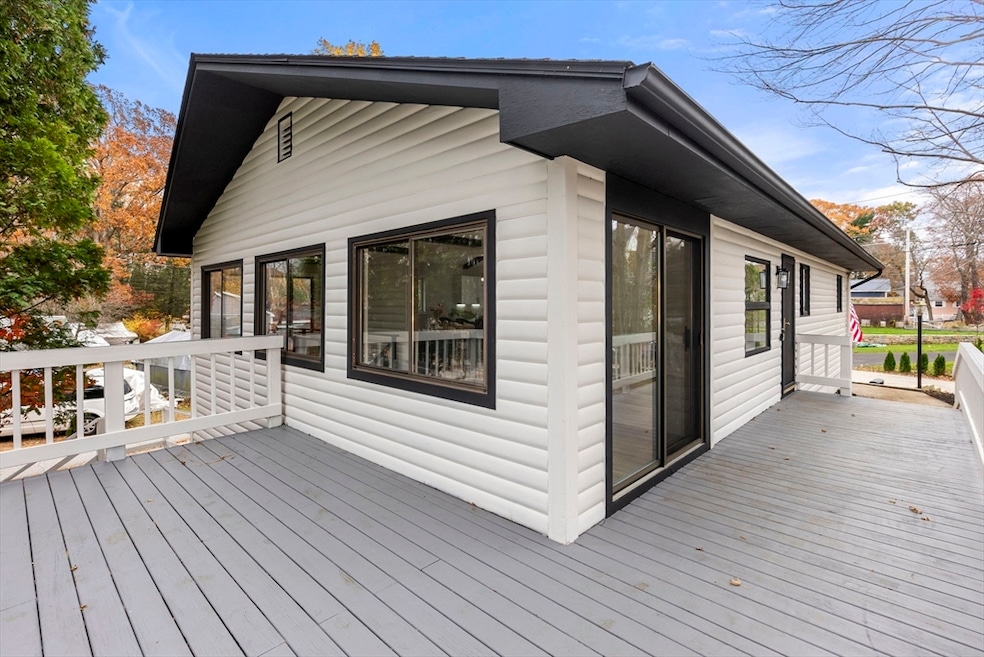
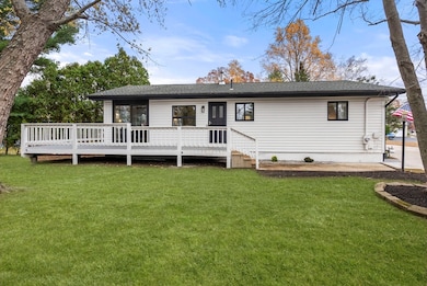
6 Henry Rd Webster, MA 01570
Estimated payment $2,538/month
Highlights
- Lake View
- Deck
- Cathedral Ceiling
- Open Floorplan
- Ranch Style House
- Bonus Room
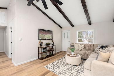
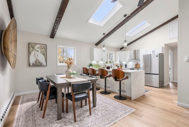
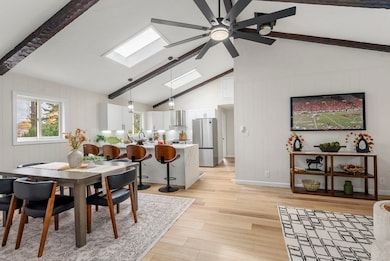
About This Home
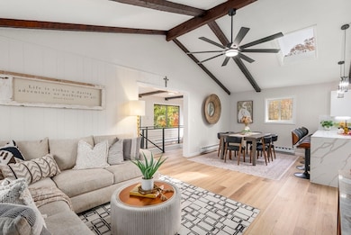
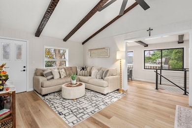
Welcome to your dream home in a desirable lake neighborhood with year-round lake views! This beautifully updated one-level home offers an inviting open-concept layout with cathedral ceilings. Enjoy a modern kitchen featuring a large peninsula with stunning quartz countertops and a waterfall edge—perfect for entertaining or casual dining. The home includes two spacious bedrooms plus a bonus sitting/office room, ideal for relaxing or working from home. The bathroom features a stylish walk-in shower and thoughtful updates, while laundry hookups are conveniently located on both the main level and in the lower-level laundry room. A massive 4-car garage with dual doors provides exceptional space for vehicles, storage, or hobbies. Have a cup of coffee on the large deck while enjoying the lake view. Easy Access to the Lake via the State Boat Ramp. Don’t miss the opportunity to own this beautiful home with gorgeous lake views—perfect for year-round living or a peaceful retreat
Home Details
Home Type
- Single Family
Est. Annual Taxes
- $3,597
Year Built
- Built in 1982
Lot Details
- 0.27 Acre Lot
- Cul-De-Sac
- Corner Lot
- Property is zoned LAKE 5
Parking
- 4 Car Attached Garage
- Tuck Under Parking
- Driveway
- Open Parking
Home Design
- Ranch Style House
- Shingle Roof
- Concrete Perimeter Foundation
Interior Spaces
- Open Floorplan
- Beamed Ceilings
- Cathedral Ceiling
- Skylights
- Insulated Windows
- Bonus Room
- Lake Views
Kitchen
- Range with Range Hood
- Dishwasher
- Kitchen Island
- Solid Surface Countertops
Flooring
- Ceramic Tile
- Vinyl
Bedrooms and Bathrooms
- 2 Bedrooms
- 1 Full Bathroom
- Double Vanity
- Separate Shower
Laundry
- Laundry Room
- Laundry on main level
- Washer and Electric Dryer Hookup
Basement
- Partial Basement
- Exterior Basement Entry
Outdoor Features
- Deck
- Rain Gutters
Schools
- Park Ave Elementry Elementary School
- Webster Middle School
- Bartlet High School
Utilities
- No Cooling
- 6 Heating Zones
- Electric Baseboard Heater
- Electric Water Heater
- High Speed Internet
Community Details
- No Home Owners Association
Listing and Financial Details
- Assessor Parcel Number M:50 B:A P:19,1748980
Map
Home Values in the Area
Average Home Value in this Area
Tax History
| Year | Tax Paid | Tax Assessment Tax Assessment Total Assessment is a certain percentage of the fair market value that is determined by local assessors to be the total taxable value of land and additions on the property. | Land | Improvement |
|---|---|---|---|---|
| 2025 | $3,597 | $302,800 | $67,800 | $235,000 |
| 2024 | $3,475 | $285,300 | $59,300 | $226,000 |
| 2023 | $3,133 | $250,600 | $56,400 | $194,200 |
| 2022 | $3,017 | $216,100 | $54,800 | $161,300 |
| 2021 | $2,967 | $196,500 | $54,800 | $141,700 |
| 2020 | $2,887 | $191,700 | $54,800 | $136,900 |
| 2019 | $2,690 | $175,500 | $54,800 | $120,700 |
| 2018 | $2,510 | $163,100 | $54,800 | $108,300 |
| 2017 | $2,391 | $158,000 | $53,700 | $104,300 |
| 2016 | $2,342 | $154,700 | $53,700 | $101,000 |
| 2015 | $2,246 | $153,000 | $52,600 | $100,400 |
Property History
| Date | Event | Price | List to Sale | Price per Sq Ft |
|---|---|---|---|---|
| 11/12/2025 11/12/25 | Pending | -- | -- | -- |
| 11/05/2025 11/05/25 | For Sale | $425,000 | -- | $314 / Sq Ft |
Purchase History
| Date | Type | Sale Price | Title Company |
|---|---|---|---|
| Deed | $195,649 | -- | |
| Deed | $195,649 | -- | |
| Quit Claim Deed | -- | -- | |
| Quit Claim Deed | -- | -- | |
| Quit Claim Deed | -- | -- | |
| Quit Claim Deed | -- | -- | |
| Deed | $113,000 | -- | |
| Deed | $113,000 | -- |
Mortgage History
| Date | Status | Loan Amount | Loan Type |
|---|---|---|---|
| Open | $229,844 | Purchase Money Mortgage | |
| Closed | $229,844 | New Conventional | |
| Previous Owner | $114,869 | No Value Available | |
| Previous Owner | $113,000 | Purchase Money Mortgage |
Source: MLS Property Information Network (MLS PIN)
MLS Number: 73451343
APN: WEBS-000050-A000000-000019
Disclaimer: Certain information contained herein is derived from information provided by parties other than Homes.com. All information provided is deemed reliable, but is not guaranteed to be accurate and should be independently verified.
![]() The property listing data and information, or the Images, set forth herein were provided to MLS Property Information Network, Inc. from third party sources, including sellers, lessors and public records, and were compiled by MLS Property Information Network, Inc. The property listing data and information, and the Images, are for the personal, non-commercial use of consumers having a good faith interest in purchasing or leasing listed properties of the type displayed to them and may not be used for any purpose other than to identify prospective properties which such consumers may have a good faith interest in purchasing or leasing. MLS Property Information Network, Inc. and its subscribers disclaim any and all representations and warranties as to the accuracy of the property listing data and information, or as to the accuracy of any of the Images, set forth herein.
The property listing data and information, or the Images, set forth herein were provided to MLS Property Information Network, Inc. from third party sources, including sellers, lessors and public records, and were compiled by MLS Property Information Network, Inc. The property listing data and information, and the Images, are for the personal, non-commercial use of consumers having a good faith interest in purchasing or leasing listed properties of the type displayed to them and may not be used for any purpose other than to identify prospective properties which such consumers may have a good faith interest in purchasing or leasing. MLS Property Information Network, Inc. and its subscribers disclaim any and all representations and warranties as to the accuracy of the property listing data and information, or as to the accuracy of any of the Images, set forth herein.
- 9 Scenic Ave
- 13 S Point Rd
- 26 Wakefield Ave
- 24 Cooper Rd
- 114 Upper Gore Rd
- 57 Upper Gore Rd
- 42 Colonial Rd
- 38 Colonial Rd
- 171 Upper Gore Rd
- 14 Colonial Rd
- 169 Upper Gore Rd
- 1 Ernest St
- 194 Killdeer Rd
- 23 Lakeview Rd
- 20 Lakeview Rd
- 27 Lakeview Rd
- 14 Browns Brook Rd
- 274 Killdeer Rd
- 27 Douglas Rd
- 0 Thompson Rd
