


6 Manning Blvd Albany, NY 12203
Pine Hills NeighborhoodEstimated payment $4,892/month
Highlights
- City View
- 0.27 Acre Lot
- Wood Flooring
- Albany High School Rated A-
- Craftsman Architecture
- Solid Surface Countertops
About This Home
*Authentic Arts and Crafts style on the Iconic Manning Bridal Path*
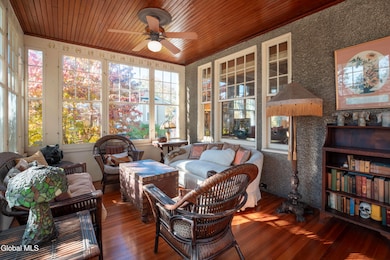
A rare opportunity to own an award-winning home on the most iconic section of Manning Boulevard. Built in 1910, this absolutely one-of-a-kind Craftsman residence boasts over 5,000 square feet of historic charm and timeless elegance. From the moment you step into the grand foyer, you'll be captivated by the rich, original millwork, stunning leaded glass, and dramatic entryway. The main floor offers expansive living spaces, including a formal living room, a cozy den with a fireplace and custom built-ins. There is a magnificent, enclosed porch that extends the full lengh of the front of the home. You will be delighted to spend your mornings in the sun drenched sunroom with southern exposure. The spacious country kitchen offers ample cabinet and prep space, perfect for both everyday living and entertaining. Upstairs, the home features 5 bedrooms and 4 baths, including a large master suite and generously sized bedrooms throughout, offering comfort and space for everyone. The exterior is just as impressive. Escape to the tranquil rear yard, a private oasis complete with a serene koi pond and a charming pergola. A large garage provides ample storage and parking. This distinguished property has been recognized for its unique character, proudly serving as the Vanguard 2008 Designer Showhouse for the Albany Symphony Orchestra. During the renovation, each room was meticulously designed by local artists and craftsmen to accentuate and maintain the beautiful architectural integrity of the house. Original fixtures and design components were preserved throughout, making this one of the rarest and most complete homes showcasing Albany's rich design history. Don't miss your chance to own a piece of Albany's history. Schedule your private showing today.
Listing Agent
Weichert Realtors-Reliable Properties License #10401345174 Listed on: 11/12/2025

Home Details
Home Type
- Single Family
Est. Annual Taxes
- $11,942
Year Built
- Built in 1910 | Remodeled
Lot Details
- 0.27 Acre Lot
- Back Yard Fenced
- Level Lot
- Garden
- Property is zoned Single Residence
Parking
- 2 Car Garage
- Garage Door Opener
Home Design
- Craftsman Architecture
- Combination Foundation
- Slate Roof
- Stucco
Interior Spaces
- 3,746 Sq Ft Home
- Built-In Features
- Chair Railings
- Crown Molding
- Paddle Fans
- Self Contained Fireplace Unit Or Insert
- Gas Fireplace
- Blinds
- Bay Window
- Entrance Foyer
- Family Room
- Living Room
- Dining Room
- City Views
- Storm Windows
- Washer and Dryer
- Unfinished Basement
Kitchen
- Gas Oven
- Range
- Microwave
- Dishwasher
- Kitchen Island
- Solid Surface Countertops
Flooring
- Wood
- Cork
- Tile
- Slate Flooring
Bedrooms and Bathrooms
- 5 Bedrooms
- Primary bedroom located on second floor
- Bathroom on Main Level
- Ceramic Tile in Bathrooms
Outdoor Features
- Enclosed Patio or Porch
Schools
- Albany High School
Utilities
- Cooling System Mounted In Outer Wall Opening
- Heating System Uses Natural Gas
- Heating System Uses Oil
- Hot Water Heating System
- Underground Utilities
- 200+ Amp Service
- High Speed Internet
Community Details
- No Home Owners Association
Listing and Financial Details
- Legal Lot and Block 18.000 / 1
- Assessor Parcel Number 010100 64.50-1-18
Map
Home Values in the Area
Average Home Value in this Area
Tax History
| Year | Tax Paid | Tax Assessment Tax Assessment Total Assessment is a certain percentage of the fair market value that is determined by local assessors to be the total taxable value of land and additions on the property. | Land | Improvement |
|---|---|---|---|---|
| 2024 | $12,034 | $468,000 | $93,600 | $374,400 |
| 2023 | $11,522 | $290,000 | $69,000 | $221,000 |
| 2022 | $11,267 | $290,000 | $69,000 | $221,000 |
| 2021 | $10,627 | $290,000 | $69,000 | $221,000 |
| 2020 | $10,365 | $290,000 | $69,000 | $221,000 |
| 2019 | $11,417 | $290,000 | $69,000 | $221,000 |
| 2018 | $10,379 | $290,000 | $69,000 | $221,000 |
| 2017 | $4,210 | $290,000 | $69,000 | $221,000 |
| 2016 | $10,072 | $290,000 | $69,000 | $221,000 |
| 2015 | $11,059 | $318,900 | $63,800 | $255,100 |
| 2014 | -- | $318,900 | $63,800 | $255,100 |
Property History
| Date | Event | Price | List to Sale | Price per Sq Ft |
|---|---|---|---|---|
| 03/07/2026 03/07/26 | Pending | -- | -- | -- |
| 11/12/2025 11/12/25 | For Sale | $749,000 | -- | $200 / Sq Ft |
Purchase History
| Date | Type | Sale Price | Title Company |
|---|---|---|---|
| Deed | -- | None Listed On Document | |
| Warranty Deed | $315,000 | Paul Knapp | |
| Interfamily Deed Transfer | -- | -- |
Source: Global MLS
MLS Number: 202529473
APN: 010100-064-050-0001-018-000-0000
Disclaimer: Certain information contained herein is derived from information provided by parties other than Homes.com. All information provided is deemed reliable, but is not guaranteed to be accurate and should be independently verified.
![]() IDX information is provided exclusively for personal, non-commercial use, and may not be used for any purpose other than to identify prospective properties consumers may be interested in purchasing.
IDX information is provided exclusively for personal, non-commercial use, and may not be used for any purpose other than to identify prospective properties consumers may be interested in purchasing.
Information is deemed reliable but not guaranteed.
Local REALTOR® - Todd Siegel, Broker - (888)-952-6393
- 17 Winthrop Ave
- 4 Marion Ave
- 84 Winthrop Ave
- 93 Homestead Ave
- 29 S Pine Ave
- 115 Homestead Ave
- 22 Fairlawn Ave
- 884 Lancaster St
- 75 S Pine Ave
- 77 S Pine Ave
- 948 Washington Ave
- 950 Washington Ave
- 148 N Pine Ave
- 118 N Allen St
- 289 W Lawrence St
- 32 Eileen St
- 959 Washington Ave
- 874 Warren St
- 860 Washington Ave
- 23 Colonial Ave
Ask me questions while you tour the home.