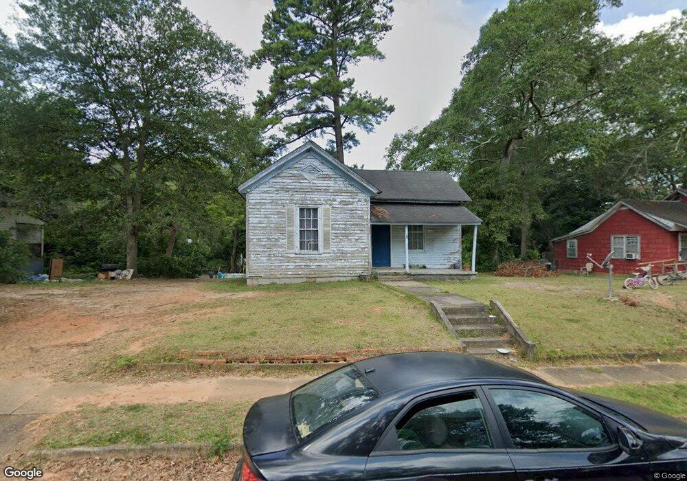
6 Maple St Manchester, GA 31816
Estimated Value: $51,836 - $100,000
2
Beds
1
Bath
1,058
Sq Ft
$70/Sq Ft
Est. Value
About This Home
Property Id: 1055739
2 Bedroom 1 bath.
An application fee is required.
Inside is freshly painted
Smoking is outside only.
Pets excepted with monthly fee of $50
New carpet is scheduled to be installed
$850 / month
$850 / deposit
Call or text
Ownership History
Date
Name
Owned For
Owner Type
Purchase Details
Closed on
Jan 19, 2021
Sold by
Adams Desus
Bought by
Ray Phillip
Current Estimated Value
Purchase Details
Closed on
Oct 30, 2020
Sold by
Tb Jordan Invetments 3 Llc
Bought by
Adams Desus
Purchase Details
Closed on
Jul 3, 2000
Sold by
Mays Sylvia Johnson
Bought by
Montgomery Robert Fr
Purchase Details
Closed on
Jun 27, 2000
Sold by
Montgomery Robert Fr
Bought by
Mcdaniel Larry E Eta
Purchase Details
Closed on
Jul 20, 1995
Sold by
Shohfi Michelle Joh
Bought by
Montgomery Robert Fr
Purchase Details
Closed on
Jun 1, 1992
Sold by
Johnson J W
Bought by
Shohfi Michelle Joh
Create a Home Valuation Report for This Property
The Home Valuation Report is an in-depth analysis detailing your home's value as well as a comparison with similar homes in the area
Home Values in the Area
Average Home Value in this Area
Purchase History
| Date | Buyer | Sale Price | Title Company |
|---|---|---|---|
| Ray Phillip | $13,000 | -- | |
| Adams Desus | $3,000 | -- | |
| Montgomery Robert Fr | -- | -- | |
| Mcdaniel Larry E Eta | $52,500 | -- | |
| Montgomery Robert Fr | -- | -- | |
| Montgomery Robert Fr | $13,500 | -- | |
| Shohfi Michelle Joh | -- | -- |
Source: Public Records
Property History
| Date | Event | Price | List to Sale | Price per Sq Ft |
|---|---|---|---|---|
| 01/08/2026 01/08/26 | Off Market | $850 | -- | -- |
| 12/05/2025 12/05/25 | For Rent | $850 | -- | -- |
Tax History
| Year | Tax Paid | Tax Assessment Tax Assessment Total Assessment is a certain percentage of the fair market value that is determined by local assessors to be the total taxable value of land and additions on the property. | Land | Improvement |
|---|---|---|---|---|
| 2025 | $260 | $5,600 | $1,200 | $4,400 |
| 2024 | $259 | $5,480 | $1,200 | $4,280 |
| 2023 | $265 | $5,480 | $1,200 | $4,280 |
| 2022 | $252 | $5,480 | $1,200 | $4,280 |
| 2021 | $175 | $5,480 | $1,200 | $4,280 |
| 2020 | $176 | $5,480 | $1,200 | $4,280 |
| 2019 | $177 | $5,480 | $1,200 | $4,280 |
| 2018 | $179 | $5,480 | $1,200 | $4,280 |
| 2017 | $181 | $5,480 | $1,200 | $4,280 |
| 2016 | $180 | $5,480 | $1,200 | $4,280 |
| 2015 | $181 | $5,480 | $1,200 | $4,280 |
| 2014 | $181 | $5,480 | $1,200 | $4,280 |
| 2013 | -- | $6,280 | $1,200 | $5,080 |
Source: Public Records
Map
Nearby Homes
Your Personal Tour Guide
Ask me questions while you tour the home.