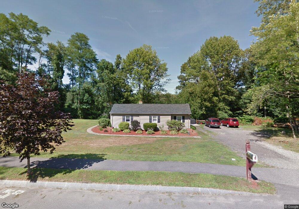
6 Mears Farm Rd Haverhill, MA 01830
Riverside NeighborhoodEstimated Value: $443,000 - $552,000
2
Beds
1
Bath
1,190
Sq Ft
$428/Sq Ft
Est. Value
About This Home
This home is located at 6 Mears Farm Rd, Haverhill, MA 01830 and is currently estimated at $509,153, approximately $427 per square foot. 6 Mears Farm Rd is a home located in Essex County with nearby schools including Dr. Paul Nettle Middle School.
Ownership History
Date
Name
Owned For
Owner Type
Purchase Details
Closed on
Oct 31, 2022
Sold by
Cook Gary L
Bought by
Cook Gary L
Current Estimated Value
Purchase Details
Closed on
Jun 30, 2021
Sold by
Cook Gary L and Cook Jean A
Bought by
Cook Gary L and Cook Jean A
Purchase Details
Closed on
Feb 6, 1963
Bought by
Cook Gary L and Cook Jean A
Create a Home Valuation Report for This Property
The Home Valuation Report is an in-depth analysis detailing your home's value as well as a comparison with similar homes in the area
Home Values in the Area
Average Home Value in this Area
Purchase History
| Date | Buyer | Sale Price | Title Company |
|---|---|---|---|
| Cook Gary L | -- | None Available | |
| Cook Gary L | -- | None Available | |
| Cook Gary L | -- | -- |
Source: Public Records
Tax History Compared to Growth
Tax History
| Year | Tax Paid | Tax Assessment Tax Assessment Total Assessment is a certain percentage of the fair market value that is determined by local assessors to be the total taxable value of land and additions on the property. | Land | Improvement |
|---|---|---|---|---|
| 2025 | $4,776 | $445,900 | $201,300 | $244,600 |
| 2024 | $4,518 | $424,600 | $191,300 | $233,300 |
| 2023 | $4,228 | $379,200 | $174,500 | $204,700 |
| 2022 | $4,055 | $318,800 | $154,400 | $164,400 |
| 2021 | $3,994 | $297,200 | $147,700 | $149,500 |
| 2020 | $3,918 | $288,100 | $146,000 | $142,100 |
| 2019 | $3,761 | $269,600 | $127,500 | $142,100 |
| 2018 | $3,676 | $257,800 | $127,500 | $130,300 |
| 2017 | $3,659 | $244,100 | $114,100 | $130,000 |
| 2016 | $3,680 | $239,600 | $114,100 | $125,500 |
| 2015 | $3,587 | $233,700 | $114,100 | $119,600 |
Source: Public Records
Map
Nearby Homes
- 89 Goodale St
- 28 Fernald Ave
- 27 Webster St
- 16 S Charles St
- 5 Pond St
- 70 Race St
- 83 S Central St Unit 83
- 8 Bartlett Ave Unit 5
- 5 Central Ave
- 7 Clinton St Unit 4
- 5 S Webster St
- 81-83 Kenoza Ave
- 300 Kenoza St
- 20 Ashland St
- 23 Arlington St
- 17 Arlington St
- 13-15 Arlington St
- 14 Greystone Ave
- 8 Fay Place
- 12 Greystone Ave Unit 12