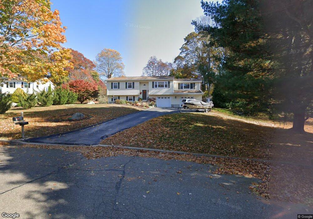
6 Paula Ln Waterford, CT 06385
Estimated Value: $435,541 - $513,000
3
Beds
2
Baths
1,456
Sq Ft
$321/Sq Ft
Est. Value
About This Home
This home is located at 6 Paula Ln, Waterford, CT 06385 and is currently estimated at $466,885, approximately $320 per square foot. 6 Paula Ln is a home located in New London County with nearby schools including Clark Lane Middle School, Waterford High School, and New London High School Multi-Magnet Campus.
Ownership History
Date
Name
Owned For
Owner Type
Purchase Details
Closed on
Feb 26, 1999
Sold by
Amanti Thomas J and Amanti Rebecca A
Bought by
Hatfield Lee E and Hatfield Suzanne T
Current Estimated Value
Home Financials for this Owner
Home Financials are based on the most recent Mortgage that was taken out on this home.
Original Mortgage
$140,000
Interest Rate
6.5%
Mortgage Type
Purchase Money Mortgage
Create a Home Valuation Report for This Property
The Home Valuation Report is an in-depth analysis detailing your home's value as well as a comparison with similar homes in the area
Home Values in the Area
Average Home Value in this Area
Purchase History
| Date | Buyer | Sale Price | Title Company |
|---|---|---|---|
| Hatfield Lee E | $182,000 | -- |
Source: Public Records
Mortgage History
| Date | Status | Borrower | Loan Amount |
|---|---|---|---|
| Open | Hatfield Lee E | $100,000 | |
| Closed | Hatfield Lee E | $100,000 | |
| Closed | Hatfield Lee E | $50,000 | |
| Closed | Hatfield Lee E | $140,000 |
Source: Public Records
Tax History Compared to Growth
Tax History
| Year | Tax Paid | Tax Assessment Tax Assessment Total Assessment is a certain percentage of the fair market value that is determined by local assessors to be the total taxable value of land and additions on the property. | Land | Improvement |
|---|---|---|---|---|
| 2025 | $5,024 | $215,080 | $81,300 | $133,780 |
| 2024 | $4,796 | $215,080 | $81,300 | $133,780 |
| 2023 | $4,560 | $215,080 | $81,300 | $133,780 |
| 2022 | $4,619 | $167,610 | $55,340 | $112,270 |
| 2021 | $4,633 | $167,610 | $55,340 | $112,270 |
| 2020 | $4,671 | $167,610 | $55,340 | $112,270 |
| 2019 | $4,690 | $167,610 | $55,340 | $112,270 |
| 2018 | $4,596 | $167,610 | $55,340 | $112,270 |
| 2017 | $4,475 | $165,560 | $55,340 | $110,220 |
| 2016 | $4,434 | $165,560 | $55,340 | $110,220 |
| 2015 | $4,276 | $165,560 | $55,340 | $110,220 |
| 2014 | $4,106 | $165,560 | $55,340 | $110,220 |
Source: Public Records
Map
Nearby Homes
- 127 Spithead Rd
- 32 Stoneheights Dr Unit 32
- 24 Stoneheights Dr
- 26 Fulmore Dr
- 164 Stoneheights Dr Unit 164
- 9 Arrowhead Trail
- 398 & 402 Boston Post Rd
- 398 Boston Post Rd
- 9 Rock Ridge Rd
- 6 Fulmore Dr
- 310 Boston Post Rd Unit 86
- 27 Mullen Hill Rd
- 182 Oswegatchie Rd
- 5 Wilcox Ct
- 37 Spithead Rd
- 270 Boston Post Rd Unit 22
- 267 Boston Post Rd
- 20 North Rd
- 163 Oswegatchie Rd
- 37 South St