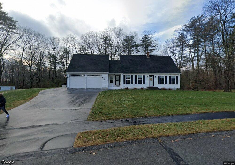
6 Stonewall Way Westbrook, ME 04092
Estimated Value: $607,221 - $638,000
3
Beds
2
Baths
2,438
Sq Ft
$254/Sq Ft
Est. Value
About This Home
This home is located at 6 Stonewall Way, Westbrook, ME 04092 and is currently estimated at $619,305, approximately $254 per square foot. 6 Stonewall Way is a home located in Cumberland County with nearby schools including Westbrook High School, St. Brigid School, and Breakwater School.
Ownership History
Date
Name
Owned For
Owner Type
Purchase Details
Closed on
Mar 3, 2009
Sold by
Lombard Bradford W and Lombard Susan L
Bought by
Brown Christopher S and Brown Anna O
Current Estimated Value
Home Financials for this Owner
Home Financials are based on the most recent Mortgage that was taken out on this home.
Original Mortgage
$227,500
Outstanding Balance
$143,659
Interest Rate
5%
Mortgage Type
Purchase Money Mortgage
Estimated Equity
$475,646
Create a Home Valuation Report for This Property
The Home Valuation Report is an in-depth analysis detailing your home's value as well as a comparison with similar homes in the area
Home Values in the Area
Average Home Value in this Area
Purchase History
| Date | Buyer | Sale Price | Title Company |
|---|---|---|---|
| Brown Christopher S | -- | -- |
Source: Public Records
Mortgage History
| Date | Status | Borrower | Loan Amount |
|---|---|---|---|
| Open | Brown Christopher S | $227,500 |
Source: Public Records
Tax History Compared to Growth
Tax History
| Year | Tax Paid | Tax Assessment Tax Assessment Total Assessment is a certain percentage of the fair market value that is determined by local assessors to be the total taxable value of land and additions on the property. | Land | Improvement |
|---|---|---|---|---|
| 2023 | $6,500 | $389,700 | $116,500 | $273,200 |
| 2022 | $5,892 | $325,500 | $97,000 | $228,500 |
| 2021 | $5,804 | $325,500 | $97,000 | $228,500 |
| 2020 | $5,813 | $325,500 | $97,000 | $228,500 |
| 2019 | $3,707 | $325,500 | $97,000 | $228,500 |
| 2018 | $4,908 | $272,800 | $84,400 | $188,400 |
| 2017 | $5,150 | $272,800 | $84,400 | $188,400 |
| 2016 | $3,436 | $272,800 | $84,400 | $188,400 |
| 2015 | $4,899 | $272,800 | $84,400 | $188,400 |
| 2014 | $4,692 | $272,800 | $84,400 | $188,400 |
| 2013 | $4,692 | $272,800 | $84,400 | $188,400 |
Source: Public Records
Map
Nearby Homes
- 471 Duck Pond Rd
- 214 Duck Pond Rd
- 20 Elmwood Ave
- 300 Brook St
- 171 Brook St Unit 2
- 171 Brook St Unit 1
- 171 Brook St Unit 41
- 171 Brook St Unit 45
- 171 Brook St Unit 65
- 171 Brook St Unit 76
- 717 Duck Pond Rd
- 21 Virginia St
- 18 Calla Lilly Ln Unit 95
- 375 Bridgton Rd Unit 43
- 145 Brooks Edge Farm Rd Unit 66
- 151 Brooks Edge Farm Rd Unit 68
- 128 Grandview Dr Unit 8
- 87 Mast Rd
- 117 Blackstrap Rd
- 98 Blackstrap Rd
- 2 Stonewall Way
- 12 Stonewall Way
- 5 Stonewall Way
- 266 Duck Pond Rd
- 380 Duck Pond Rd
- 11 Stonewall Way
- 311 Duck Pond Rd
- 289 Duck Pond Rd
- 0 Stonewall
- 346 Duck Pond Rd
- 281 Duck Pond Rd
- 254 Duck Pond Rd
- 22 Stonewall Way
- 350 Duck Pond Rd
- 23 Stonewall Way
- 250 Duck Pond Rd
- 26 Stonewall Way
- 263 Duck Pond Rd
- 19 Wayne Rd
- Lot 57 Duck Pond Rd