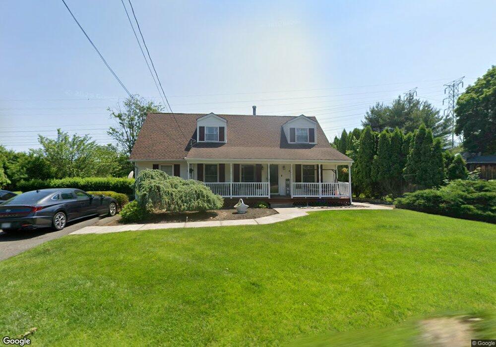
60 Cinder Rd Stony Point, NY 10980
Estimated Value: $626,487 - $676,000
3
Beds
2
Baths
1,677
Sq Ft
$386/Sq Ft
Est. Value
About This Home
This home is located at 60 Cinder Rd, Stony Point, NY 10980 and is currently estimated at $647,872, approximately $386 per square foot. 60 Cinder Rd is a home located in Rockland County with nearby schools including West Haverstraw Elementary School, Haverstraw Elementary School, and Fieldstone Secondary School.
Ownership History
Date
Name
Owned For
Owner Type
Purchase Details
Closed on
Sep 20, 2007
Sold by
Altomonte Glen A
Bought by
Weber Jennifer
Current Estimated Value
Home Financials for this Owner
Home Financials are based on the most recent Mortgage that was taken out on this home.
Original Mortgage
$387,000
Outstanding Balance
$246,025
Interest Rate
6.65%
Mortgage Type
Purchase Money Mortgage
Estimated Equity
$401,847
Purchase Details
Closed on
Oct 26, 1995
Sold by
Longendyke Jeanne and Longendyke Clifford H
Bought by
Altomonte Glen A
Home Financials for this Owner
Home Financials are based on the most recent Mortgage that was taken out on this home.
Original Mortgage
$80,883
Interest Rate
8.21%
Mortgage Type
Construction
Create a Home Valuation Report for This Property
The Home Valuation Report is an in-depth analysis detailing your home's value as well as a comparison with similar homes in the area
Home Values in the Area
Average Home Value in this Area
Purchase History
| Date | Buyer | Sale Price | Title Company |
|---|---|---|---|
| Weber Jennifer | $430,000 | Foresight Title Agency Llc | |
| Altomonte Glen A | $90,000 | Chicago Title Insurance Co |
Source: Public Records
Mortgage History
| Date | Status | Borrower | Loan Amount |
|---|---|---|---|
| Open | Weber Jennifer | $387,000 | |
| Previous Owner | Altomonte Glen A | $80,883 |
Source: Public Records
Tax History
| Year | Tax Paid | Tax Assessment Tax Assessment Total Assessment is a certain percentage of the fair market value that is determined by local assessors to be the total taxable value of land and additions on the property. | Land | Improvement |
|---|---|---|---|---|
| 2024 | $14,258 | $40,600 | $10,500 | $30,100 |
| 2023 | $14,258 | $40,600 | $10,500 | $30,100 |
| 2022 | $3,730 | $40,600 | $10,500 | $30,100 |
| 2021 | $3,730 | $40,600 | $10,500 | $30,100 |
| 2020 | $9,663 | $40,600 | $10,500 | $30,100 |
| 2019 | $3,147 | $40,600 | $10,500 | $30,100 |
| 2018 | $9,264 | $40,600 | $10,500 | $30,100 |
| 2017 | $9,095 | $40,600 | $10,500 | $30,100 |
| 2016 | $9,395 | $40,600 | $10,500 | $30,100 |
| 2015 | -- | $40,600 | $10,500 | $30,100 |
| 2014 | -- | $40,600 | $10,500 | $30,100 |
Source: Public Records
Map
Nearby Homes
- 18 Lake Rd
- 33 de Halve Maen Dr
- 15 Pine Dr
- 50 Major Andre Dr
- 11 Centennial Dr
- 10 Roman Acres Dr
- 57 Mountain View Mobile Home Park
- 30 Govan Dr
- 20 Madison Ave
- 161 Washburns Ln
- 807 Battalion Dr
- 178 Washburns Ln
- 40 N Route 9w
- 15 Wenzel Ln
- 78 Church St
- 21 Janet Place
- 3 N Mountain View
- 21 Bridge St
- 20 Main St Unit 39
- 20 Main St Unit 20
Your Personal Tour Guide
Ask me questions while you tour the home.