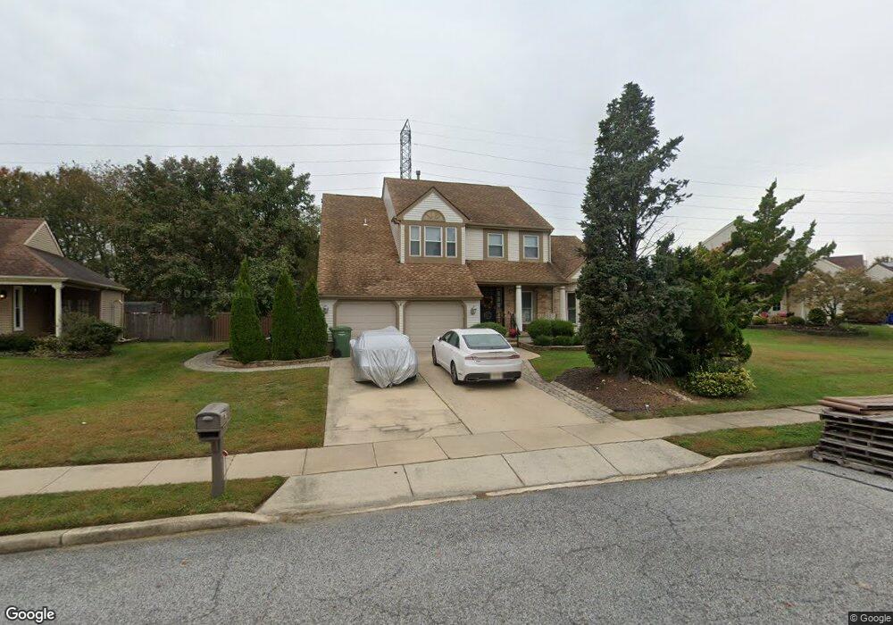
60 Hawk Ln Marlton, NJ 08053
Estimated Value: $588,471 - $678,000
--
Bed
--
Bath
2,705
Sq Ft
$235/Sq Ft
Est. Value
About This Home
This home is located at 60 Hawk Ln, Marlton, NJ 08053 and is currently estimated at $635,368, approximately $234 per square foot. 60 Hawk Ln is a home located in Burlington County with nearby schools including Robert B. Jaggard School, Marlton Middle School, and Cherokee High School.
Ownership History
Date
Name
Owned For
Owner Type
Purchase Details
Closed on
Oct 3, 2024
Sold by
Quillen Mark
Bought by
Quillen Evelyn and Dangelo Rita
Current Estimated Value
Purchase Details
Closed on
Jul 30, 1999
Sold by
Reed James T and Reed Linda A
Bought by
Quillen Mark L and Quillen Evelyn M
Home Financials for this Owner
Home Financials are based on the most recent Mortgage that was taken out on this home.
Original Mortgage
$150,000
Interest Rate
7.65%
Create a Home Valuation Report for This Property
The Home Valuation Report is an in-depth analysis detailing your home's value as well as a comparison with similar homes in the area
Home Values in the Area
Average Home Value in this Area
Purchase History
| Date | Buyer | Sale Price | Title Company |
|---|---|---|---|
| Quillen Evelyn | -- | None Listed On Document | |
| Quillen Mark L | $194,000 | Security First Title Partner |
Source: Public Records
Mortgage History
| Date | Status | Borrower | Loan Amount |
|---|---|---|---|
| Previous Owner | Quillen Mark L | $150,000 |
Source: Public Records
Tax History Compared to Growth
Tax History
| Year | Tax Paid | Tax Assessment Tax Assessment Total Assessment is a certain percentage of the fair market value that is determined by local assessors to be the total taxable value of land and additions on the property. | Land | Improvement |
|---|---|---|---|---|
| 2025 | $11,153 | $326,600 | $100,000 | $226,600 |
| 2024 | $10,494 | $326,600 | $100,000 | $226,600 |
| 2023 | $10,494 | $326,600 | $100,000 | $226,600 |
| 2022 | $10,023 | $326,600 | $100,000 | $226,600 |
| 2021 | $9,788 | $326,600 | $100,000 | $226,600 |
| 2020 | $9,661 | $326,600 | $100,000 | $226,600 |
| 2019 | $9,582 | $326,600 | $100,000 | $226,600 |
| 2018 | $9,449 | $326,600 | $100,000 | $226,600 |
| 2017 | $9,337 | $326,600 | $100,000 | $226,600 |
| 2016 | $9,109 | $326,600 | $100,000 | $226,600 |
| 2015 | $8,949 | $326,600 | $100,000 | $226,600 |
| 2014 | $8,694 | $326,600 | $100,000 | $226,600 |
Source: Public Records
Map
Nearby Homes
- 22 Hawk Ln
- 63 Banner Ct Unit 63
- 38 Ashley Ct Unit 38
- 7 Quaker St
- 293 Ivy Ct
- 800 Marlowe Rd
- 220 Deerpark Ct
- 201 Empress Ct
- 26 Regent Rd
- 128 Cambridge Ave
- 209 Henfield Ave
- 118 Cambridge Ave
- 145 Kilburn Dr
- 61 S Maple Ave
- 319 Mimosa Dr
- 100 Cambridge Ave
- 12 Princess Ave
- 110 Conestoga Dr
- 100 E Eagle Ln
- 22 E Split Rock Dr