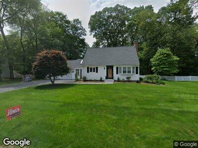
60 Rogers Rd East Longmeadow, MA 01028
Estimated Value: $370,735 - $426,000
3
Beds
2
Baths
1,547
Sq Ft
$260/Sq Ft
Est. Value
About This Home
This home is located at 60 Rogers Rd, East Longmeadow, MA 01028 and is currently estimated at $402,934, approximately $260 per square foot. 60 Rogers Rd is a home located in Hampden County with nearby schools including Meadowbrook Elementary School, Birchland Park Middle School, and East Longmeadow High School.
Ownership History
Date
Name
Owned For
Owner Type
Purchase Details
Closed on
Jun 25, 2015
Sold by
Diclementi Therese and Malone Edward
Bought by
Goodwin Sara and Goodwin James
Current Estimated Value
Home Financials for this Owner
Home Financials are based on the most recent Mortgage that was taken out on this home.
Original Mortgage
$248,900
Interest Rate
3.84%
Mortgage Type
New Conventional
Purchase Details
Closed on
Sep 5, 2007
Sold by
Teden-Doe Mary M and Malone Mary M
Bought by
Diclementi Therese and Malone Edward
Create a Home Valuation Report for This Property
The Home Valuation Report is an in-depth analysis detailing your home's value as well as a comparison with similar homes in the area
Home Values in the Area
Average Home Value in this Area
Purchase History
| Date | Buyer | Sale Price | Title Company |
|---|---|---|---|
| Goodwin Sara | $262,000 | -- | |
| Diclementi Therese | -- | -- |
Source: Public Records
Mortgage History
| Date | Status | Borrower | Loan Amount |
|---|---|---|---|
| Open | Goodwin Sara | $32,000 | |
| Open | Goodwin James | $291,000 | |
| Closed | Goodwin Sara | $236,000 | |
| Closed | Goodwin Sara | $248,900 | |
| Previous Owner | Teden-Doe Mary M | $110,000 | |
| Previous Owner | Teden-Doe Mary M | $35,469 | |
| Previous Owner | Malone Mary M | $65,000 | |
| Previous Owner | Teden-Doe Mary M | $35,000 | |
| Previous Owner | Teden-Doe Mary M | $50,000 | |
| Previous Owner | Teden-Doe Mary M | $25,000 |
Source: Public Records
Tax History Compared to Growth
Tax History
| Year | Tax Paid | Tax Assessment Tax Assessment Total Assessment is a certain percentage of the fair market value that is determined by local assessors to be the total taxable value of land and additions on the property. | Land | Improvement |
|---|---|---|---|---|
| 2025 | $6,644 | $359,500 | $116,600 | $242,900 |
| 2024 | $6,331 | $341,500 | $116,600 | $224,900 |
| 2023 | $5,996 | $312,300 | $105,900 | $206,400 |
| 2022 | $5,718 | $281,800 | $96,300 | $185,500 |
| 2021 | $5,200 | $246,900 | $89,200 | $157,700 |
| 2020 | $4,977 | $238,800 | $89,200 | $149,600 |
| 2019 | $4,770 | $232,100 | $86,600 | $145,500 |
| 2018 | $4,634 | $221,300 | $86,600 | $134,700 |
| 2017 | $4,499 | $216,600 | $84,600 | $132,000 |
| 2016 | $4,492 | $212,700 | $82,100 | $130,600 |
| 2015 | $4,815 | $232,400 | $82,100 | $150,300 |
Source: Public Records
Map
Nearby Homes
- 101 Melwood Ave
- 23 Rogers Rd
- 9 Knollwood Dr
- 90 Westwood Ave
- Lot 13 Farmer Cir
- Lot 21 Farmer Cir
- 3 Birch Ave
- 37 White Ave
- 0 Donald Ave
- 10 Callender Ave
- LOT 18 Farmer Cir
- Lot 24 Happy Acres Ln
- Lot 22 Farmer Cir
- 3 North St
- 50 Broadleaf Cir Unit 50
- 80 Somers Rd
- 53 Gail St
- 236 Williamsburg Dr
- 277 Dwight Rd
- 232 Prospect St