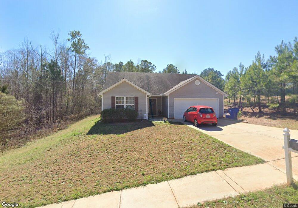
60 Sampson Ct Covington, GA 30016
Estimated Value: $243,000 - $267,000
3
Beds
2
Baths
1,332
Sq Ft
$192/Sq Ft
Est. Value
About This Home
This home is located at 60 Sampson Ct, Covington, GA 30016 and is currently estimated at $255,788, approximately $192 per square foot. 60 Sampson Ct is a home located in Newton County with nearby schools including Oak Hill Elementary School, Veterans Memorial Middle School, and Alcovy High School.
Ownership History
Date
Name
Owned For
Owner Type
Purchase Details
Closed on
Jul 11, 2019
Sold by
Martin Norman S
Bought by
Martin Elizabeth Laurel
Current Estimated Value
Home Financials for this Owner
Home Financials are based on the most recent Mortgage that was taken out on this home.
Original Mortgage
$80,000
Outstanding Balance
$69,634
Interest Rate
3.82%
Mortgage Type
New Conventional
Estimated Equity
$186,154
Purchase Details
Closed on
Mar 2, 2011
Sold by
Martin Norman S and Martin Nancy W
Bought by
Martin Elizabeth L and Martin Nancy W
Purchase Details
Closed on
Mar 19, 2010
Sold by
Hard Labor R/E Invtrs Llc
Bought by
Martin Norman S and Martin Nancy W
Home Financials for this Owner
Home Financials are based on the most recent Mortgage that was taken out on this home.
Original Mortgage
$54,000
Interest Rate
4.93%
Mortgage Type
New Conventional
Purchase Details
Closed on
Aug 11, 2009
Sold by
Homemax Of Georgia Llc
Bought by
First Piedmont Bank
Create a Home Valuation Report for This Property
The Home Valuation Report is an in-depth analysis detailing your home's value as well as a comparison with similar homes in the area
Home Values in the Area
Average Home Value in this Area
Purchase History
| Date | Buyer | Sale Price | Title Company |
|---|---|---|---|
| Martin Elizabeth Laurel | -- | -- | |
| Martin Elizabeth L | -- | -- | |
| Martin Norman S | $69,800 | -- | |
| First Piedmont Bank | $48,898 | -- |
Source: Public Records
Mortgage History
| Date | Status | Borrower | Loan Amount |
|---|---|---|---|
| Open | Martin Elizabeth Laurel | $80,000 | |
| Previous Owner | Martin Norman S | $54,000 |
Source: Public Records
Tax History
| Year | Tax Paid | Tax Assessment Tax Assessment Total Assessment is a certain percentage of the fair market value that is determined by local assessors to be the total taxable value of land and additions on the property. | Land | Improvement |
|---|---|---|---|---|
| 2025 | $2,587 | $108,160 | $15,200 | $92,960 |
| 2024 | $2,495 | $100,040 | $15,200 | $84,840 |
| 2023 | $2,464 | $92,520 | $8,000 | $84,520 |
| 2022 | $1,796 | $67,840 | $8,000 | $59,840 |
| 2021 | $1,656 | $56,520 | $8,000 | $48,520 |
| 2020 | $1,576 | $49,080 | $8,000 | $41,080 |
| 2019 | $1,588 | $48,760 | $8,000 | $40,760 |
| 2018 | $1,347 | $41,440 | $6,000 | $35,440 |
| 2017 | $1,275 | $39,360 | $6,000 | $33,360 |
| 2016 | $1,252 | $38,680 | $7,200 | $31,480 |
| 2015 | $750 | $24,120 | $3,200 | $20,920 |
| 2014 | $750 | $24,120 | $0 | $0 |
Source: Public Records
Map
Nearby Homes
- 125 Sampson Ct
- 30 Amber Way
- 105 Edinburgh Ln Unit 2
- 45 Edinburgh Ln Unit 2
- 20 Tarpley Way
- 1586 Butler Bridge Rd
- 325 Tarpley Way
- 768 Wehunt Rd
- 55 the Falls Blvd
- 5618 Highway 212
- 290 the Falls Blvd
- 30 Creekside Ct
- 20 N River Rd
- 40 Hunters Crossing
- 255 Hugh Dr
- 35 Nicole Ct
- 50 Butler Bridge Cir
- 931 Bethany Rd
- 110 Chapel Heights Way
- 4627 Highway 212
- 50 Sampson Ct Unit 4
- 50 Sampson Ct
- 105 Sampson Ct
- 40 Sampson Ct Unit 3
- 40 Sampson Ct
- 95 Sampson Ct
- 95 Sampson Ct Unit 2
- 85 Sampson Ct
- 75 Sampson Ct
- 275 Saratoga Ct
- 80 Sampson Ct
- 295 Saratoga Ct
- 285 Saratoga Ct
- 20 Sampson Ct
- 25 Ryans Cir
- 265 Saratoga Ct
- 65 Sampson Ct
- 90 Sampson Ct
- 305 Saratoga Ct
- 30 Ryans Cir
Your Personal Tour Guide
Ask me questions while you tour the home.