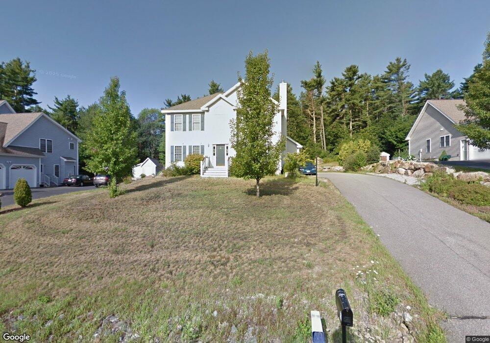
60 Sandstone Dr Bedford, NH 03110
Bedford NeighborhoodEstimated Value: $819,035 - $898,000
3
Beds
3
Baths
2,758
Sq Ft
$317/Sq Ft
Est. Value
About This Home
This home is located at 60 Sandstone Dr, Bedford, NH 03110 and is currently estimated at $874,009, approximately $316 per square foot. 60 Sandstone Dr is a home located in Hillsborough County with nearby schools including Mckelvie Intermediate School, Ross A. Lurgio Middle School, and Bedford High School.
Ownership History
Date
Name
Owned For
Owner Type
Purchase Details
Closed on
Apr 2, 2019
Sold by
Caron Robert L
Bought by
Rlc Ret
Current Estimated Value
Purchase Details
Closed on
Jul 10, 2001
Sold by
Ml-96 Invsts Inc
Bought by
Caron Robert L and Caron Karen T
Create a Home Valuation Report for This Property
The Home Valuation Report is an in-depth analysis detailing your home's value as well as a comparison with similar homes in the area
Home Values in the Area
Average Home Value in this Area
Purchase History
| Date | Buyer | Sale Price | Title Company |
|---|---|---|---|
| Rlc Ret | -- | -- | |
| Caron Robert L | $296,900 | -- |
Source: Public Records
Mortgage History
| Date | Status | Borrower | Loan Amount |
|---|---|---|---|
| Previous Owner | Caron Robert L | $70,000 | |
| Previous Owner | Caron Robert L | $299,000 | |
| Previous Owner | Caron Robert L | $101,000 | |
| Previous Owner | Caron Robert L | $100,000 |
Source: Public Records
Tax History Compared to Growth
Tax History
| Year | Tax Paid | Tax Assessment Tax Assessment Total Assessment is a certain percentage of the fair market value that is determined by local assessors to be the total taxable value of land and additions on the property. | Land | Improvement |
|---|---|---|---|---|
| 2024 | $11,715 | $741,000 | $218,600 | $522,400 |
| 2023 | $10,967 | $741,000 | $218,600 | $522,400 |
| 2022 | $10,074 | $572,400 | $161,900 | $410,500 |
| 2021 | $9,811 | $572,400 | $161,900 | $410,500 |
| 2020 | $9,672 | $483,100 | $124,500 | $358,600 |
| 2019 | $9,155 | $483,100 | $124,500 | $358,600 |
| 2018 | $9,058 | $444,000 | $124,500 | $319,500 |
| 2017 | $8,396 | $444,000 | $124,500 | $319,500 |
| 2016 | $8,362 | $373,800 | $99,500 | $274,300 |
| 2015 | $8,508 | $373,800 | $99,500 | $274,300 |
| 2014 | $8,411 | $373,800 | $99,500 | $274,300 |
| 2013 | $8,287 | $373,800 | $99,500 | $274,300 |
Source: Public Records
Map
Nearby Homes
- 3 Danforth Dr
- 21 Prairie Ct
- 58 Violet St
- 90 Glenwood Ave
- 133 Bismark St
- 122 Patterson St
- 380 Rockland Ave
- 99 Becker St
- 40 Tirrell Hill Rd
- 220 Mast Rd
- 52 Erie St
- 0 Huntress St
- 60 Geneva St
- 46 Geneva St
- 25 Saint Marie St
- 80 Wendover Way
- 24 Whippoorwill Ln
- 18 Grand Ave Unit Lot 7
- 15 Grand Ave Unit Lot 3
- 17 Grand Ave
- 62 Sandstone Dr
- 56 Sandstone Dr
- 64 Sandstone Dr
- 55 Rundlett Hill Rd
- 64 Constance St
- 51 Rundlett Hill Rd
- 66 Sandstone Dr
- 57 Sandstone Dr
- 47 Rundlett Hill Rd
- 68 Sandstone Dr
- 67 Constance St
- 62 Constance St
- 46 Sandstone Dr
- 61 Rundlett Hill Rd
- 32 Savoie St
- 49 Sandstone Dr
- 54 Rundlett Hill Rd
- 45 Rundlett Hill Rd
- 60 Constance St
- 65 Constance St