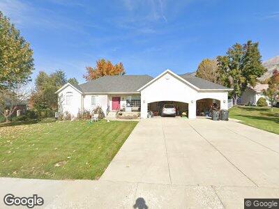
60 W 650 N Lindon, UT 84042
Estimated Value: $700,000 - $827,000
3
Beds
2
Baths
1,774
Sq Ft
$435/Sq Ft
Est. Value
About This Home
This home is located at 60 W 650 N, Lindon, UT 84042 and is currently estimated at $771,014, approximately $434 per square foot. 60 W 650 N is a home located in Utah County with nearby schools including Lindon Elementary School, Oak Canyon Junior High School, and Pleasant Grove High School.
Ownership History
Date
Name
Owned For
Owner Type
Purchase Details
Closed on
Feb 7, 2023
Sold by
Maddox Charle Lee
Bought by
Maddox Giuliana M
Current Estimated Value
Home Financials for this Owner
Home Financials are based on the most recent Mortgage that was taken out on this home.
Original Mortgage
$50,000
Outstanding Balance
$49,059
Interest Rate
6.27%
Mortgage Type
New Conventional
Purchase Details
Closed on
Jun 19, 2001
Sold by
Nelson Philip E and Nelson Janie M
Bought by
Maddox Charles L and Maddox Guiliana M
Create a Home Valuation Report for This Property
The Home Valuation Report is an in-depth analysis detailing your home's value as well as a comparison with similar homes in the area
Home Values in the Area
Average Home Value in this Area
Purchase History
| Date | Buyer | Sale Price | Title Company |
|---|---|---|---|
| Maddox Charles L | -- | First American Title Insuran |
Source: Public Records
Mortgage History
| Date | Status | Borrower | Loan Amount |
|---|---|---|---|
| Open | Maddox Giuliana M | $50,000 | |
| Previous Owner | Maddox Giuliana M | $10,000 | |
| Previous Owner | Maddox Charles L | $50,000 |
Source: Public Records
Tax History Compared to Growth
Tax History
| Year | Tax Paid | Tax Assessment Tax Assessment Total Assessment is a certain percentage of the fair market value that is determined by local assessors to be the total taxable value of land and additions on the property. | Land | Improvement |
|---|---|---|---|---|
| 2024 | $3,175 | $406,945 | $0 | $0 |
| 2023 | $3,173 | $420,090 | $0 | $0 |
| 2022 | $3,208 | $410,355 | $0 | $0 |
| 2021 | $2,719 | $524,500 | $279,500 | $245,000 |
| 2020 | $2,579 | $489,700 | $254,100 | $235,600 |
| 2019 | $2,237 | $443,100 | $207,500 | $235,600 |
| 2018 | $2,237 | $417,700 | $182,100 | $235,600 |
| 2017 | $2,248 | $225,060 | $0 | $0 |
| 2016 | $2,241 | $207,515 | $0 | $0 |
| 2015 | $2,145 | $187,825 | $0 | $0 |
| 2014 | $1,911 | $165,715 | $0 | $0 |
Source: Public Records
Map
Nearby Homes
- 778 N 40 E
- 227 W 800 N
- 1065 E 900 S
- 498 N 80 W
- 106 E 710 N
- 160 E 710 N
- 863 S 1150 E
- 823 S 875 E
- 336 W Songbird Ln Unit 19
- 764 E 760 S
- 913 S 1320 E
- 388 W Songbird Ln Unit 4
- 1580 W 700 N Unit 2
- 307 E 680 N
- 550 S Loader Dr
- 682 Trailsend Ct
- 1446 E Murdock Dr
- 359 E 680 N
- 499 N 420 W Unit 138
- 1479 E 860 S