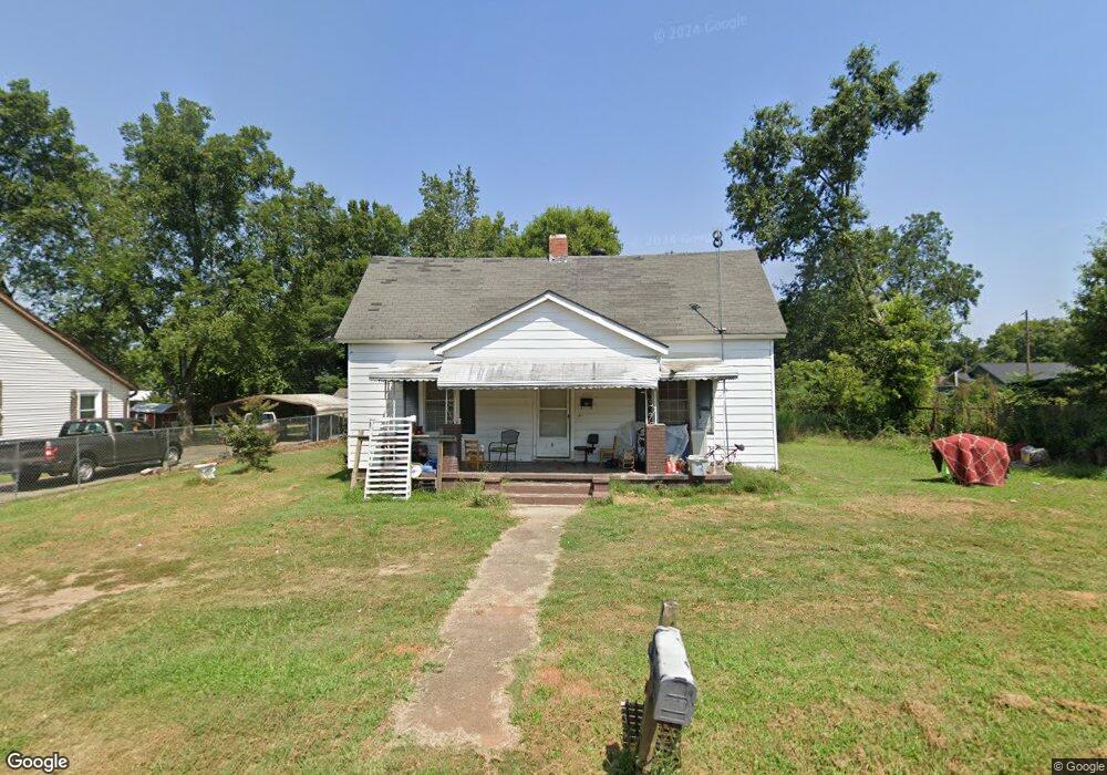
600 Don Ave Anderson, SC 29624
Estimated Value: $67,598 - $186,000
2
Beds
1
Bath
1,295
Sq Ft
$90/Sq Ft
Est. Value
About This Home
This home is located at 600 Don Ave, Anderson, SC 29624 and is currently estimated at $116,900, approximately $90 per square foot. 600 Don Ave is a home located in Anderson County with nearby schools including Varennes Elementary School, Robert Anderson Middle School, and Westside High School.
Ownership History
Date
Name
Owned For
Owner Type
Purchase Details
Closed on
Sep 16, 2024
Sold by
Albert Timothy
Bought by
Gaines Gloria Nahama
Current Estimated Value
Purchase Details
Closed on
Nov 4, 2015
Sold by
Home Opportunity Llc
Bought by
Albert Timothy
Purchase Details
Closed on
Apr 3, 2013
Sold by
Transportation Alliance Bank Inc
Bought by
Home Opportunity Llc
Purchase Details
Closed on
Jun 12, 2012
Sold by
Home Solutions Partners Iii Reo Llc
Bought by
Transportation Alliance Bank Inc
Purchase Details
Closed on
Jun 15, 2010
Sold by
Cyr Jeffrey R
Bought by
Home Solutions Partners Iii Reo Llc
Purchase Details
Closed on
Feb 11, 2005
Sold by
Laur Rocky
Bought by
Cyr Jeffrey
Purchase Details
Closed on
Dec 20, 2004
Sold by
Fri Inc
Bought by
Cyr Jeffrey and Laur Rocky
Purchase Details
Closed on
Sep 24, 1999
Sold by
Holcombe Frances V
Bought by
Fri Inc
Create a Home Valuation Report for This Property
The Home Valuation Report is an in-depth analysis detailing your home's value as well as a comparison with similar homes in the area
Home Values in the Area
Average Home Value in this Area
Purchase History
| Date | Buyer | Sale Price | Title Company |
|---|---|---|---|
| Gaines Gloria Nahama | -- | None Listed On Document | |
| Albert Timothy | $1,554 | -- | |
| Home Opportunity Llc | -- | -- | |
| Transportation Alliance Bank Inc | $23,156 | -- | |
| Home Solutions Partners Iii Reo Llc | -- | -- | |
| Cyr Jeffrey | -- | -- | |
| Cyr Jeffrey | $23,166 | -- | |
| Fri Inc | $10,000 | -- |
Source: Public Records
Tax History Compared to Growth
Tax History
| Year | Tax Paid | Tax Assessment Tax Assessment Total Assessment is a certain percentage of the fair market value that is determined by local assessors to be the total taxable value of land and additions on the property. | Land | Improvement |
|---|---|---|---|---|
| 2024 | $570 | $1,510 | $300 | $1,210 |
| 2023 | $570 | $1,510 | $300 | $1,210 |
| 2022 | $528 | $1,510 | $300 | $1,210 |
| 2021 | $527 | $1,390 | $210 | $1,180 |
| 2020 | $517 | $1,390 | $210 | $1,180 |
| 2019 | $517 | $1,390 | $210 | $1,180 |
| 2018 | $511 | $1,390 | $210 | $1,180 |
| 2017 | -- | $1,390 | $210 | $1,180 |
| 2016 | $570 | $1,610 | $270 | $1,340 |
| 2015 | $573 | $1,610 | $270 | $1,340 |
| 2014 | $561 | $1,610 | $270 | $1,340 |
Source: Public Records
Map
Nearby Homes
- 16 N Prince St
- 6 Herring Ave
- 1606 S Murray Avenue Extension
- 46 S Lyons St
- 612 Martha Dr
- 1619 Nardin Ave
- 1502 Nardin Ave
- 1609 S Mcduffie St
- 00 Hwy 28 Bypass New Pond Rd
- 1709 Lyndon Ave
- 1413 S Mcduffie St
- 310 W Hampton St
- 1616 Meadowbrook Cir
- 308 W Hampton St
- 1411 S Mcduffie St
- 1609 Lyndon Ave
- 431 Lewis St
- 1103 Scott Dr
- 701 Delia St
- 701 Delia St Unit B