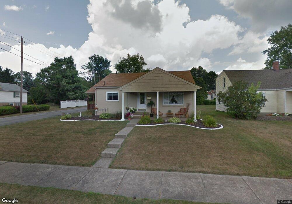
600 Joan Ave Girard, OH 44420
Estimated Value: $115,000 - $143,534
2
Beds
1
Bath
1,080
Sq Ft
$124/Sq Ft
Est. Value
About This Home
This home is located at 600 Joan Ave, Girard, OH 44420 and is currently estimated at $133,884, approximately $123 per square foot. 600 Joan Ave is a home located in Trumbull County with nearby schools including Prospect Elementary School, Girard Intermediate School, and Girard Junior High School.
Ownership History
Date
Name
Owned For
Owner Type
Purchase Details
Closed on
Feb 25, 2013
Sold by
Rau Dan A and Rau Mary Helen
Bought by
Rau Matthew C and Jennings Michele J
Current Estimated Value
Purchase Details
Closed on
Sep 5, 1997
Sold by
Stringer Mary Claire and Stringer Barry Mary Claire
Bought by
Rau Dan A and Rau Mary Helen
Home Financials for this Owner
Home Financials are based on the most recent Mortgage that was taken out on this home.
Original Mortgage
$40,000
Interest Rate
7.54%
Purchase Details
Closed on
Jan 1, 1990
Bought by
Mary Claire Stringer
Create a Home Valuation Report for This Property
The Home Valuation Report is an in-depth analysis detailing your home's value as well as a comparison with similar homes in the area
Home Values in the Area
Average Home Value in this Area
Purchase History
| Date | Buyer | Sale Price | Title Company |
|---|---|---|---|
| Rau Matthew C | -- | None Available | |
| Rau Dan A | $68,500 | -- | |
| Mary Claire Stringer | -- | -- |
Source: Public Records
Mortgage History
| Date | Status | Borrower | Loan Amount |
|---|---|---|---|
| Previous Owner | Rau Dan A | $40,000 |
Source: Public Records
Tax History
| Year | Tax Paid | Tax Assessment Tax Assessment Total Assessment is a certain percentage of the fair market value that is determined by local assessors to be the total taxable value of land and additions on the property. | Land | Improvement |
|---|---|---|---|---|
| 2024 | $1,145 | $38,190 | $4,870 | $33,320 |
| 2023 | $1,176 | $38,190 | $4,870 | $33,320 |
| 2022 | $932 | $26,570 | $4,870 | $21,700 |
| 2021 | $935 | $26,570 | $4,870 | $21,700 |
| 2020 | $947 | $26,570 | $4,870 | $21,700 |
| 2019 | $891 | $24,610 | $4,870 | $19,740 |
| 2018 | $934 | $24,610 | $4,870 | $19,740 |
| 2017 | $931 | $24,610 | $4,870 | $19,740 |
| 2016 | $943 | $24,230 | $4,870 | $19,360 |
| 2015 | $932 | $24,230 | $4,870 | $19,360 |
| 2014 | $932 | $24,230 | $4,870 | $19,360 |
| 2013 | $1,014 | $25,910 | $4,870 | $21,040 |
Source: Public Records
Map
Nearby Homes
- 417 Otis Ct SE
- 500 Forsythe Ave
- 238 E Main St
- 521 Powers Ave
- 216 E Main St
- 349 Forsythe Ave
- 445 Powers Ave
- 148 E Wilson Ave
- 1094 Churchill Rd
- 401 Indiana Ave
- 202 E Prospect St
- 131 S State St
- 0 S State St Unit 5124606
- 432 Taylor Ave
- 620 Washington Ave
- 1600 Motor Inn Dr
- 0 W Wilson Ave
- 14 N Lorain Ave
- 970 N Ward Ave
- 111 Churchill Rd
Your Personal Tour Guide
Ask me questions while you tour the home.