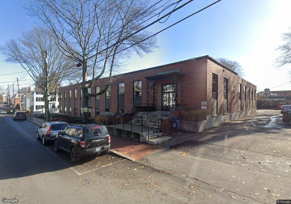
600 State St Unit 2 Portsmouth, NH 03801
West End NeighborhoodEstimated Value: $557,232
--
Bed
--
Bath
1,833
Sq Ft
$304/Sq Ft
Est. Value
About This Home
This home is located at 600 State St Unit 2, Portsmouth, NH 03801 and is currently estimated at $557,232, approximately $304 per square foot. 600 State St Unit 2 is a home located in Rockingham County with nearby schools including Little Harbour School, Portsmouth Middle School, and Portsmouth High School.
Ownership History
Date
Name
Owned For
Owner Type
Purchase Details
Closed on
Mar 22, 2002
Sold by
Semprini Wayne P and Semprini Paulette D
Bought by
Sachem Holdings Llc
Current Estimated Value
Home Financials for this Owner
Home Financials are based on the most recent Mortgage that was taken out on this home.
Original Mortgage
$115,000
Outstanding Balance
$47,531
Interest Rate
6.91%
Mortgage Type
Commercial
Estimated Equity
$509,701
Create a Home Valuation Report for This Property
The Home Valuation Report is an in-depth analysis detailing your home's value as well as a comparison with similar homes in the area
Home Values in the Area
Average Home Value in this Area
Purchase History
| Date | Buyer | Sale Price | Title Company |
|---|---|---|---|
| Sachem Holdings Llc | $195,000 | -- |
Source: Public Records
Mortgage History
| Date | Status | Borrower | Loan Amount |
|---|---|---|---|
| Open | Sachem Holdings Llc | $115,000 |
Source: Public Records
Tax History Compared to Growth
Tax History
| Year | Tax Paid | Tax Assessment Tax Assessment Total Assessment is a certain percentage of the fair market value that is determined by local assessors to be the total taxable value of land and additions on the property. | Land | Improvement |
|---|---|---|---|---|
| 2024 | $3,957 | $353,900 | $0 | $353,900 |
| 2023 | $3,923 | $243,200 | $0 | $243,200 |
| 2022 | $3,697 | $243,200 | $0 | $243,200 |
| 2021 | $3,655 | $243,200 | $0 | $243,200 |
| 2020 | $3,575 | $243,200 | $0 | $243,200 |
| 2019 | $3,609 | $242,900 | $0 | $242,900 |
| 2018 | $3,721 | $234,900 | $0 | $234,900 |
| 2017 | $3,613 | $234,900 | $0 | $234,900 |
| 2016 | $3,958 | $232,300 | $0 | $232,300 |
| 2015 | $3,900 | $232,300 | $0 | $232,300 |
| 2014 | $3,522 | $194,600 | $0 | $194,600 |
| 2013 | $3,485 | $194,600 | $0 | $194,600 |
| 2012 | $3,415 | $194,600 | $0 | $194,600 |
Source: Public Records
Map
Nearby Homes
- 4 Rock St Unit B
- 198 Islington St Unit 6
- 51 Islington St Unit 406
- 332 Hanover St
- 92 Brewster St
- 115 Court St
- 99 Foundry Place Unit 106
- 99 Foundry Place Unit 408
- 99 Foundry Place Unit 102
- 99 Foundry Place Unit 310
- 99 Foundry Place Unit 109
- 99 Foundry Place Unit 308
- 99 Foundry Place Unit 208
- 99 Foundry Place Unit 101
- 99 Foundry Place Unit 207
- 99 Foundry Place Unit 301
- 99 Foundry Place Unit 206
- 99 Foundry Place Unit 103
- 70 Maplewood Ave Unit 305
- 70 Maplewood Ave Unit 202
- 600 State St Unit A
- 600 State St
- 600 State St Unit 3
- 552 State St
- 606 State St
- 606 State St Unit A
- 606 State St Unit C
- 579 State St Apt 1 St
- 542 State St
- 608 State St
- 477 State St Unit B
- 477 State St
- 579 State St Unit 7
- 579 State St Unit 2
- 579 State St Unit 3
- 579 State St Unit 1
- 180 Middle St
- 180 Middle St Unit 5
- 180 Middle St Unit 1
- 180 Middle St Unit 3