Estimated Value: $238,233 - $258,000
4
Beds
2
Baths
1,224
Sq Ft
$204/Sq Ft
Est. Value
About This Home
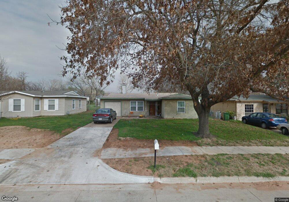
This home is located at 601 Brookfield Dr, Hurst, TX 76053 and is currently estimated at $250,058, approximately $204 per square foot. 601 Brookfield Dr is a home located in Tarrant County with nearby schools including Bellaire Elementary School, Hurst J High School, and L.D. Bell High School.
Ownership History
Date
Name
Owned For
Owner Type
Purchase Details
Closed on
Oct 28, 2025
Sold by
True Dfw Homes-1 Llc
Bought by
Sfr Owner 2 Llc
Current Estimated Value
Purchase Details
Closed on
Sep 8, 2015
Sold by
Timber Holdings Llc
Bought by
True Dfw2015-1 Homes Llc
Purchase Details
Closed on
Sep 26, 2014
Sold by
Henry Don Clarke and Henry Don C
Bought by
Timber Holdings Llc
Create a Home Valuation Report for This Property
The Home Valuation Report is an in-depth analysis detailing your home's value as well as a comparison with similar homes in the area
Home Values in the Area
Average Home Value in this Area
Purchase History
| Date | Buyer | Sale Price | Title Company |
|---|---|---|---|
| Sfr Owner 2 Llc | -- | Stewart Title | |
| True Dfw2015-1 Homes Llc | -- | Avenue 365 Lender Services | |
| Timber Holdings Llc | -- | First American Title |
Source: Public Records
Tax History
| Year | Tax Paid | Tax Assessment Tax Assessment Total Assessment is a certain percentage of the fair market value that is determined by local assessors to be the total taxable value of land and additions on the property. | Land | Improvement |
|---|---|---|---|---|
| 2025 | $3,466 | $196,560 | $50,000 | $146,560 |
| 2024 | $3,466 | $216,000 | $50,000 | $166,000 |
| 2023 | $3,466 | $173,000 | $35,000 | $138,000 |
| 2022 | $3,638 | $158,000 | $35,000 | $123,000 |
| 2021 | $3,811 | $158,000 | $35,000 | $123,000 |
| 2020 | $3,078 | $127,930 | $35,000 | $92,930 |
| 2019 | $3,131 | $127,930 | $35,000 | $92,930 |
| 2018 | $2,490 | $101,744 | $15,000 | $86,744 |
| 2017 | $2,328 | $91,982 | $15,000 | $76,982 |
| 2016 | $2,286 | $90,349 | $15,000 | $75,349 |
| 2015 | $1,770 | $67,500 | $15,000 | $52,500 |
| 2014 | $1,770 | $67,500 | $15,000 | $52,500 |
Source: Public Records
Map
Nearby Homes
- 42 Page St
- 705 Timbercreek Dr
- 413 Wanda Way
- 740 Shady Ln
- 212 E Ellen Ave
- 424 Holder Dr
- 4106 Hollow Oak Dr
- 312 E Ellen Ave
- 260 Corinna Ct
- 1306 Driftwood Dr
- 1309 Driftwood Dr
- 205 Corinna Ct
- 552 Norwood Dr
- 47 Donald Ct
- 609 Norwood Dr
- 840 Forest Hollow Dr
- 905 Forest Hollow Dr
- 802 Brown Trail
- 808 Lee Dr
- 701 Harrison Ln
- 511 Brookfield Dr
- 603 Brookfield Dr
- 507 Brookfield Dr
- 607 Brookfield Dr
- 600 Greenway Dr
- 604 Greenway Dr
- 512 Greenway Dr
- 503 Brookfield Dr
- 611 Brookfield Dr
- 608 Greenway Dr
- 508 Greenway Dr
- 600 Brookfield Dr
- 604 Brookfield Dr
- 512 Brookfield Dr
- 608 Brookfield Dr
- 615 Brookfield Dr
- 612 Greenway Dr
- 508 Brookfield Dr
- 452 Michael Blvd
- 448 Michael Blvd
Your Personal Tour Guide
Ask me questions while you tour the home.