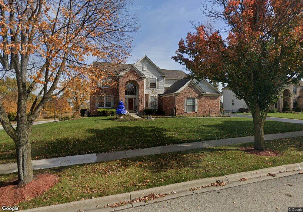
601 Brookside Ave Algonquin, IL 60102
Far West Algonquin NeighborhoodEstimated Value: $537,810 - $631,000
4
Beds
4
Baths
2,955
Sq Ft
$200/Sq Ft
Est. Value
About This Home
This home is located at 601 Brookside Ave, Algonquin, IL 60102 and is currently estimated at $590,453, approximately $199 per square foot. 601 Brookside Ave is a home located in McHenry County with nearby schools including Westfield Community School, Lincoln Prairie Elementary School, and Harry D Jacobs High School.
Ownership History
Date
Name
Owned For
Owner Type
Purchase Details
Closed on
Mar 2, 2002
Sold by
Jenkins Timothy J and Jenkins Alejandra
Bought by
Zimmermann Ryan Cynthia M
Current Estimated Value
Home Financials for this Owner
Home Financials are based on the most recent Mortgage that was taken out on this home.
Original Mortgage
$290,000
Interest Rate
6.34%
Purchase Details
Closed on
Nov 3, 2000
Sold by
Pulte Home Corp
Bought by
Jenkins Timothy J and Jenkins Alejandra
Home Financials for this Owner
Home Financials are based on the most recent Mortgage that was taken out on this home.
Original Mortgage
$337,050
Interest Rate
7.91%
Create a Home Valuation Report for This Property
The Home Valuation Report is an in-depth analysis detailing your home's value as well as a comparison with similar homes in the area
Home Values in the Area
Average Home Value in this Area
Purchase History
| Date | Buyer | Sale Price | Title Company |
|---|---|---|---|
| Zimmermann Ryan Cynthia M | $347,500 | Multiple | |
| Jenkins Timothy J | $374,520 | First American |
Source: Public Records
Mortgage History
| Date | Status | Borrower | Loan Amount |
|---|---|---|---|
| Previous Owner | Zimmermann Ryan Cynthia M | $290,000 | |
| Previous Owner | Jenkins Timothy J | $337,050 |
Source: Public Records
Tax History
| Year | Tax Paid | Tax Assessment Tax Assessment Total Assessment is a certain percentage of the fair market value that is determined by local assessors to be the total taxable value of land and additions on the property. | Land | Improvement |
|---|---|---|---|---|
| 2024 | $11,090 | $157,761 | $30,076 | $127,685 |
| 2023 | $10,472 | $141,097 | $26,899 | $114,198 |
| 2022 | $10,591 | $134,497 | $26,553 | $107,944 |
| 2021 | $10,586 | $125,300 | $24,737 | $100,563 |
| 2020 | $10,314 | $120,864 | $23,861 | $97,003 |
| 2019 | $10,071 | $115,682 | $22,838 | $92,844 |
| 2018 | $11,444 | $126,066 | $21,097 | $104,969 |
| 2017 | $11,229 | $118,762 | $19,875 | $98,887 |
| 2016 | $11,082 | $111,388 | $18,641 | $92,747 |
| 2013 | -- | $109,886 | $17,390 | $92,496 |
Source: Public Records
Map
Nearby Homes
- 601 Woods Creek Ln
- 16 Springbrook Ln
- 3610 Lakeview Dr
- 2660 Harnish Dr
- 3260 Nottingham Dr
- 4241 Wanderlust Dr
- 940 Treeline Dr
- 531 Alpine Dr
- 895 Eineke Blvd
- 4 Greenbrier Ct
- 3650 Wintergreen Terrace
- 432 Thunder Ridge
- 2930 Harnish Dr
- 2380 Dawson Ln Unit 165
- 2956 Harnish Dr
- 1157 Sawmill Ln
- 305 Harvest Gate
- 2612 Loren Ln Unit 293
- 212 Rhinebeck Way
- 1171 Kingsmill Dr
- 611 Brookside Ave
- 591 Brookside Ave
- 610 Brookside Ave
- 600 Brookside Ave
- 621 Brookside Ave
- 620 Brookside Ave
- 581 Brookside Ave
- 631 Brookside Ave
- 611 Saratoga Cir
- 601 Saratoga Cir
- 621 Saratoga Cir
- 630 Brookside Ave
- 580 Brookside Ave
- 571 Brookside Ave
- 631 Saratoga Cir
- 591 Saratoga Cir
- 641 Brookside Ave
- 641 Saratoga Cir
- 570 Brookside Ave
- 640 Brookside Ave
Your Personal Tour Guide
Ask me questions while you tour the home.