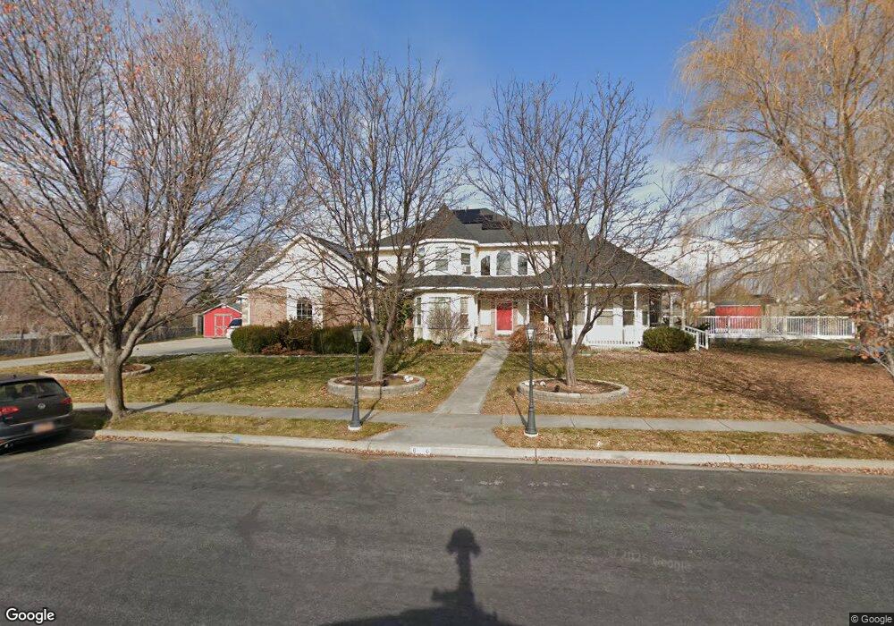
6016 W 10150 N Highland, UT 84003
Estimated Value: $855,000 - $964,000
6
Beds
4
Baths
4,059
Sq Ft
$229/Sq Ft
Est. Value
About This Home
This home is located at 6016 W 10150 N, Highland, UT 84003 and is currently estimated at $928,430, approximately $228 per square foot. 6016 W 10150 N is a home located in Utah County with nearby schools including Freedom Elementary School, Mountain Ridge Junior High School, and American Fork High School.
Ownership History
Date
Name
Owned For
Owner Type
Purchase Details
Closed on
Jun 4, 2021
Sold by
Campbell Steven M and Campbell Sharlene
Bought by
Kimball Rebecca Lynn and Kimball Matthew Alan
Current Estimated Value
Home Financials for this Owner
Home Financials are based on the most recent Mortgage that was taken out on this home.
Original Mortgage
$546,000
Outstanding Balance
$494,335
Interest Rate
2.9%
Mortgage Type
New Conventional
Estimated Equity
$434,095
Purchase Details
Closed on
Jun 9, 2003
Sold by
Campbell Steven M
Bought by
Campbell Steven M and Campbell Sharlene
Purchase Details
Closed on
May 30, 2003
Sold by
Tedjamulia Alvin and Tedjamulia Canah
Bought by
Campbell Steven Michael
Purchase Details
Closed on
Aug 4, 1999
Sold by
Eldredge J Lloyd and Eldredge Hazel Ann
Bought by
Tedjamulia Alvin and Tedjamulia Canah
Purchase Details
Closed on
May 11, 1999
Sold by
Eldredge J Lloyd
Bought by
Eldredge J Lloyd and Eldredge Hazel Ann
Home Financials for this Owner
Home Financials are based on the most recent Mortgage that was taken out on this home.
Original Mortgage
$34,000
Interest Rate
6.94%
Purchase Details
Closed on
Mar 5, 1999
Sold by
Eldredge J Lloyd
Bought by
Eldredge J Lloyd and Eldredge Hazel Ann
Home Financials for this Owner
Home Financials are based on the most recent Mortgage that was taken out on this home.
Original Mortgage
$288,000
Interest Rate
6.7%
Purchase Details
Closed on
May 27, 1997
Sold by
Stevens Tex L and Stevens Shelley G
Bought by
Eldredge Joseph Lloyd and Eldredge Hazel Ann
Home Financials for this Owner
Home Financials are based on the most recent Mortgage that was taken out on this home.
Original Mortgage
$233,700
Interest Rate
8.13%
Create a Home Valuation Report for This Property
The Home Valuation Report is an in-depth analysis detailing your home's value as well as a comparison with similar homes in the area
Home Values in the Area
Average Home Value in this Area
Purchase History
| Date | Buyer | Sale Price | Title Company |
|---|---|---|---|
| Kimball Rebecca Lynn | -- | Utah First Title Ins Agcy | |
| Campbell Steven M | -- | Empire Land Title Company | |
| Campbell Steven M | -- | Empire Land Title Company | |
| Campbell Steven Michael | -- | Empire Land Title Company | |
| Tedjamulia Alvin | -- | First American Title Ins Co | |
| Eldredge J Lloyd | -- | Summit Title Insurance Agenc | |
| Eldredge J Lloyd | -- | Summit Title Insurance Agenc | |
| Eldredge J Lloyd | -- | Summit Title Co | |
| Eldredge J Lloyd | -- | Summit Title Co | |
| Eldredge Joseph Lloyd | -- | First American Title |
Source: Public Records
Mortgage History
| Date | Status | Borrower | Loan Amount |
|---|---|---|---|
| Open | Kimball Rebecca Lynn | $546,000 | |
| Previous Owner | Eldredge J Lloyd | $34,000 | |
| Previous Owner | Eldredge J Lloyd | $288,000 | |
| Previous Owner | Eldredge Joseph Lloyd | $233,700 |
Source: Public Records
Tax History Compared to Growth
Tax History
| Year | Tax Paid | Tax Assessment Tax Assessment Total Assessment is a certain percentage of the fair market value that is determined by local assessors to be the total taxable value of land and additions on the property. | Land | Improvement |
|---|---|---|---|---|
| 2025 | $3,532 | $475,530 | $356,600 | $508,000 |
| 2024 | $3,532 | $436,205 | $0 | $0 |
| 2023 | $3,351 | $446,490 | $0 | $0 |
| 2022 | $3,310 | $427,625 | $0 | $0 |
| 2021 | $3,070 | $590,800 | $215,700 | $375,100 |
| 2020 | $2,924 | $551,800 | $187,600 | $364,200 |
| 2019 | $2,697 | $532,400 | $187,600 | $344,800 |
| 2018 | $2,624 | $492,400 | $171,300 | $321,100 |
| 2017 | $2,250 | $225,335 | $0 | $0 |
| 2016 | $2,341 | $219,120 | $0 | $0 |
| 2015 | $2,420 | $214,665 | $0 | $0 |
| 2014 | $2,414 | $212,245 | $0 | $0 |
Source: Public Records
Map
Nearby Homes
- 5973 W 9960 N
- 11337 N 5950 W Unit 7
- 6190 W 10050 N
- 10197 N 5750 W
- 9780 N 6000 W
- 9947 N Yorkshire Ct
- 6399 W 10150 N
- 703 S 850 W
- 5586 W 10130 N
- 6372 W 10400 N
- 10434 N 6400 W
- 6373 W 10500 N
- 5433 W 10130 N
- 9924 N 6630 W Unit 9
- 1438 N 400 W
- 5378 W 10130 N
- 35 W 1350 N
- 287 W 1360 N
- 10507 N 5470 W
- 9967 N 6670 W
- 6046 W 10150 N
- 10105 N 6000 W
- 6038 W 10050 N
- 6012 W 10050 N
- 5958 W 10100 N
- 10157 N 5950 W
- 6050 W 10050 N
- 5959 W 10100 N
- 6005 W 10050 N
- 6031 W 10050 N
- 10058 N 6000 W
- 6104 W 10150 N
- 6086 W 10050 N
- 10140 N 6000 W
- 10179 N 5950 W
- 10122 N 5950 W
- 6045 W 10050 N
- 10024 N 6000 W
- 10087 N Vineyard Ct
- 10146 N 5950 W