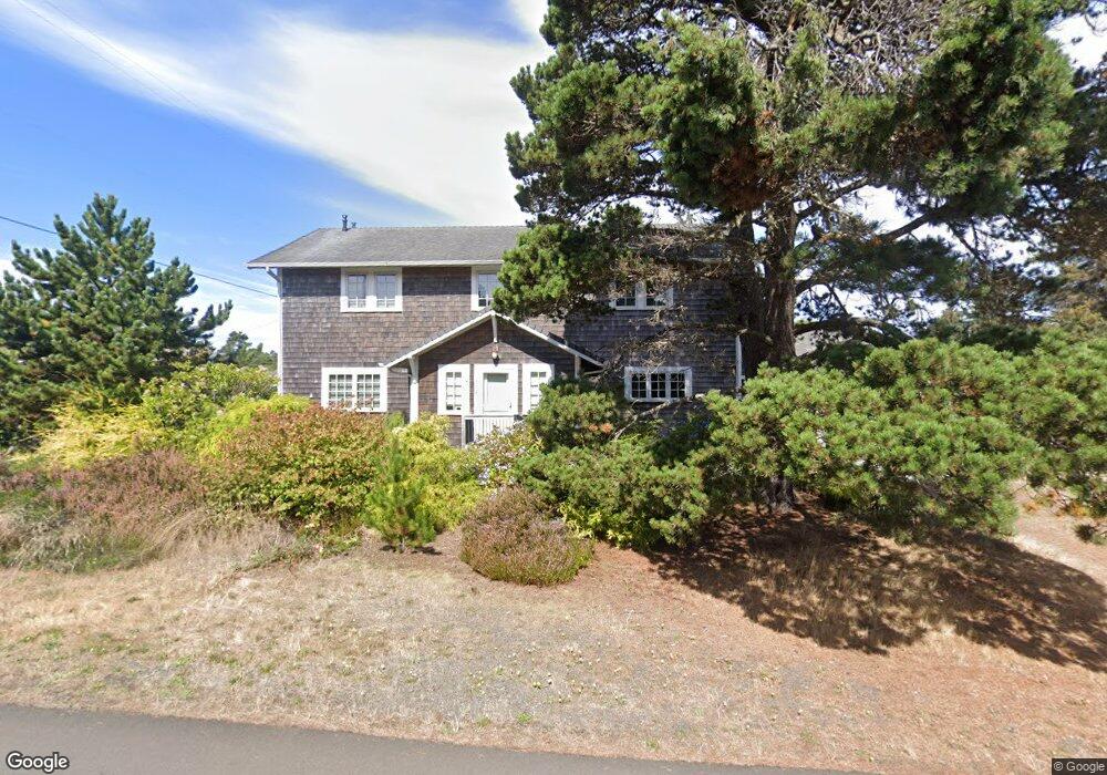
602 D St Gearhart, OR 97138
Estimated Value: $779,000 - $1,277,000
4
Beds
5
Baths
1,366
Sq Ft
$735/Sq Ft
Est. Value
About This Home
This home is located at 602 D St, Gearhart, OR 97138 and is currently estimated at $1,003,740, approximately $734 per square foot. 602 D St is a home located in Clatsop County with nearby schools including Seaside High School.
Ownership History
Date
Name
Owned For
Owner Type
Purchase Details
Closed on
Feb 3, 2021
Sold by
Walker John David and Walker Family Trust
Bought by
Walker John David and Walker Family Trust
Current Estimated Value
Purchase Details
Closed on
Aug 6, 2019
Sold by
Dierdorff Walker John D and Dierdorff Walker Ross
Bought by
Walker John David and Walker Ross Dicrdorff
Purchase Details
Closed on
Mar 14, 2007
Sold by
Elsenbach Chris P and Elsenbach Vicki A
Bought by
Dierdorff Walker John D and Dierdorff Walker Ross
Purchase Details
Closed on
Jan 19, 2006
Sold by
Barry Thomas R and Barry Mary G
Bought by
Elsenbach Christopher P and Elsenbach Vicki A
Create a Home Valuation Report for This Property
The Home Valuation Report is an in-depth analysis detailing your home's value as well as a comparison with similar homes in the area
Home Values in the Area
Average Home Value in this Area
Purchase History
| Date | Buyer | Sale Price | Title Company |
|---|---|---|---|
| Walker John David | -- | None Available | |
| Walker John David | -- | None Available | |
| Dierdorff Walker John D | $340,000 | Ticor Title Ins Co | |
| Elsenbach Christopher P | $325,000 | Multiple |
Source: Public Records
Tax History Compared to Growth
Tax History
| Year | Tax Paid | Tax Assessment Tax Assessment Total Assessment is a certain percentage of the fair market value that is determined by local assessors to be the total taxable value of land and additions on the property. | Land | Improvement |
|---|---|---|---|---|
| 2024 | $4,353 | $380,631 | -- | -- |
| 2023 | $4,231 | $369,545 | $0 | $0 |
| 2022 | $4,105 | $358,783 | $0 | $0 |
| 2021 | $4,190 | $348,334 | $0 | $0 |
| 2020 | $4,042 | $338,189 | $0 | $0 |
| 2019 | $3,938 | $328,339 | $0 | $0 |
| 2018 | $3,795 | $318,777 | $0 | $0 |
| 2017 | $3,695 | $309,493 | $0 | $0 |
| 2016 | $3,192 | $300,479 | $99,936 | $200,543 |
| 2015 | $3,087 | $291,728 | $97,026 | $194,702 |
| 2014 | $2,934 | $283,232 | $0 | $0 |
| 2013 | -- | $274,984 | $0 | $0 |
Source: Public Records
Map
Nearby Homes
- 0 Wellington Ave Unit 25-48
- 0 Wellington Ave Unit 1202
- 1265 D St
- 196 Dylan Ct
- 924 Little Beach Dr
- 415 Spruce Ave
- 782 Woodland Ct
- 1396 N Ocean Ave
- Lots 25-26 5th St
- 3387-3389 U S 101
- 3389 U S 101
- 0 5th St
- 714 7th St
- 1065 Picture Place
- 261 Railroad Ave
- 1054 Picture Place
- 2624 Neawanna St
- 2549 Neawanna St
- 1324 Sea Ridge Ln