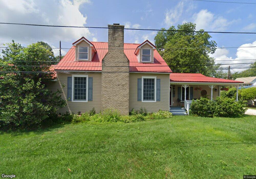
602 Division St Saint Michaels, MD 21663
Estimated Value: $771,000 - $943,000
--
Bed
3
Baths
2,342
Sq Ft
$365/Sq Ft
Est. Value
About This Home
This home is located at 602 Division St, Saint Michaels, MD 21663 and is currently estimated at $855,684, approximately $365 per square foot. 602 Division St is a home located in Talbot County with nearby schools including St. Michaels Elementary School, St. Michaels Middle/High School, and Easton High School.
Ownership History
Date
Name
Owned For
Owner Type
Purchase Details
Closed on
Aug 9, 2007
Sold by
Tyler George S
Bought by
Greaves Patricia S
Current Estimated Value
Purchase Details
Closed on
Jul 21, 2007
Sold by
Tyler George S
Bought by
Greaves Patricia S
Purchase Details
Closed on
Aug 19, 2003
Sold by
Parks William Roger
Bought by
Tyler George S and Tyler Cynther P
Create a Home Valuation Report for This Property
The Home Valuation Report is an in-depth analysis detailing your home's value as well as a comparison with similar homes in the area
Home Values in the Area
Average Home Value in this Area
Purchase History
| Date | Buyer | Sale Price | Title Company |
|---|---|---|---|
| Greaves Patricia S | $570,000 | -- | |
| Greaves Patricia S | $570,000 | -- | |
| Tyler George S | $269,000 | -- |
Source: Public Records
Tax History Compared to Growth
Tax History
| Year | Tax Paid | Tax Assessment Tax Assessment Total Assessment is a certain percentage of the fair market value that is determined by local assessors to be the total taxable value of land and additions on the property. | Land | Improvement |
|---|---|---|---|---|
| 2025 | $4,888 | $552,700 | $216,700 | $336,000 |
| 2024 | $4,888 | $530,433 | $0 | $0 |
| 2023 | $4,683 | $508,167 | $0 | $0 |
| 2022 | $4,501 | $485,900 | $216,700 | $269,200 |
| 2021 | $4,440 | $476,900 | $0 | $0 |
| 2020 | $4,440 | $467,900 | $0 | $0 |
| 2019 | $4,430 | $458,900 | $183,300 | $275,600 |
| 2018 | $4,322 | $433,433 | $0 | $0 |
| 2017 | $4,159 | $407,967 | $0 | $0 |
| 2016 | $3,681 | $382,500 | $0 | $0 |
| 2015 | $4,448 | $382,500 | $0 | $0 |
| 2014 | $4,448 | $382,500 | $0 | $0 |
Source: Public Records
Map
Nearby Homes
- 100 Grace St
- 107 E Chestnut St
- 0 Grace St Unit MDTA2012346
- 105 Seymour Ave
- Lot 16A Meadow St
- 704 Meadow St
- 222 E Chestnut St
- 216 E Chew Ave
- 102 Gloria Ave
- 807 Radcliff Ave
- 207 Dodson Ave
- 408 Spinnaker Ln
- 25500 Chance Farm Rd
- 209 Webb Ln
- 300 Perry St
- 216 Brooks Ln
- 912 Calvert Ave
- 24390 Oakwood Park Rd
- 228 Tyler Ave
- 24318 Oakwood Park Rd
- 111 W Marengo St
- 200 W Chew Ave
- 114 W Chew Ave
- 700 Division St
- 112 W Chew Ave
- 110 W Chew Ave
- 112 W Marengo St
- 208 W Chew Ave
- 110 W Marengo St
- 109 W Marengo St
- 108 W Chew Ave
- 203 W Chew Ave
- 108 W Marengo St
- 106 W Chew Ave
- 701 Division St
- 205 W Chew Ave
- 107 W Marengo St
- 201 W Chew Ave
- 111 W Maple Ave
- 106 W Marengo St