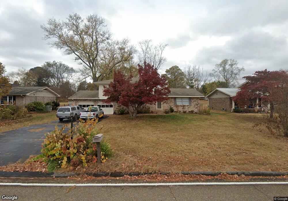
6029 Clark Rd Harrison, TN 37341
Estimated Value: $309,000 - $354,000
4
Beds
3
Baths
2,029
Sq Ft
$160/Sq Ft
Est. Value
About This Home
This home is located at 6029 Clark Rd, Harrison, TN 37341 and is currently estimated at $324,600, approximately $159 per square foot. 6029 Clark Rd is a home located in Hamilton County with nearby schools including Harrison Elementary School, Brown Middle School, and Central High School.
Ownership History
Date
Name
Owned For
Owner Type
Purchase Details
Closed on
Feb 9, 2018
Sold by
Lasley Steven W
Bought by
Hamill Jessica R
Current Estimated Value
Purchase Details
Closed on
Jan 16, 2018
Sold by
Leasley Rebecca J
Bought by
Leasley Steven W
Purchase Details
Closed on
Mar 15, 2010
Sold by
Benton Richard D and Benton Jennie R
Bought by
Lasley Steven W and Lasley Rebecca J
Home Financials for this Owner
Home Financials are based on the most recent Mortgage that was taken out on this home.
Original Mortgage
$147,184
Interest Rate
5.01%
Mortgage Type
FHA
Create a Home Valuation Report for This Property
The Home Valuation Report is an in-depth analysis detailing your home's value as well as a comparison with similar homes in the area
Home Values in the Area
Average Home Value in this Area
Purchase History
| Date | Buyer | Sale Price | Title Company |
|---|---|---|---|
| Hamill Jessica R | $154,000 | Valley Title Services Llc | |
| Leasley Steven W | -- | Title Guaranty & Trust Co | |
| Lasley Steven W | $149,900 | Title Guaranty & Trust |
Source: Public Records
Mortgage History
| Date | Status | Borrower | Loan Amount |
|---|---|---|---|
| Previous Owner | Lasley Steven W | $147,184 |
Source: Public Records
Tax History
| Year | Tax Paid | Tax Assessment Tax Assessment Total Assessment is a certain percentage of the fair market value that is determined by local assessors to be the total taxable value of land and additions on the property. | Land | Improvement |
|---|---|---|---|---|
| 2025 | $1,116 | $73,650 | $0 | $0 |
| 2024 | $1,128 | $50,425 | $0 | $0 |
| 2023 | $1,137 | $50,425 | $0 | $0 |
| 2022 | $1,137 | $50,425 | $0 | $0 |
| 2021 | $1,137 | $50,425 | $0 | $0 |
| 2020 | $1,183 | $42,450 | $0 | $0 |
| 2019 | $1,183 | $42,450 | $0 | $0 |
| 2018 | $1,183 | $42,450 | $0 | $0 |
| 2017 | $1,183 | $42,450 | $0 | $0 |
| 2016 | $1,087 | $0 | $0 | $0 |
| 2015 | $1,087 | $39,000 | $0 | $0 |
| 2014 | $1,087 | $0 | $0 | $0 |
Source: Public Records
Map
Nearby Homes
- 7010 Barleyfield Dr
- 5902 Tyner Ln
- 5900 Tyner Ln
- 6117 Pythian Rd
- 9223 Sunny Shore Ln
- 6039 Porter Dr
- 6010 Porter Dr
- 6725 Harbor Terrace
- 9113 Edgewater Rd
- 6821 Lakeshore Dr
- 6434 Waconda Point Rd
- 6591 Chipmunk Dr
- 4819 Montcrest Dr Unit 2
- 6915 Sentinel Ln
- 6432 Cobble Ln
- 9208 Misty Ridge Dr
- 5958 Congress Ln
- 7004 Lystra Rd
- 6106 Lottie Ln
- 7004 Sleigh Ln
Your Personal Tour Guide
Ask me questions while you tour the home.