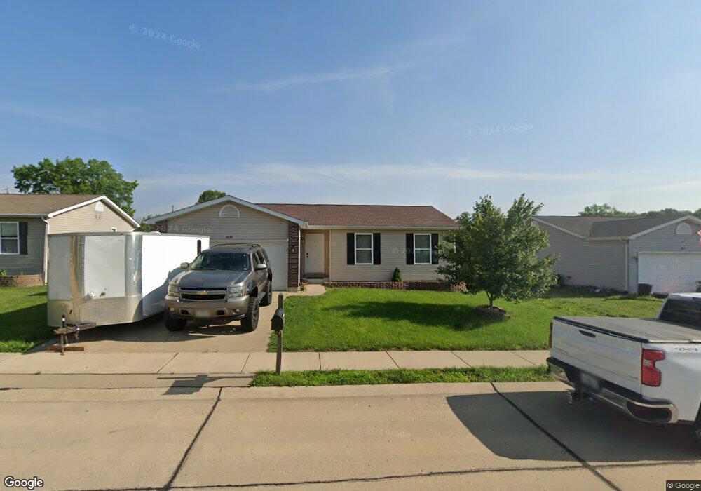
6029 Cross Pointe Dr Cedar Hill, MO 63016
Estimated Value: $216,592 - $267,000
3
Beds
2
Baths
972
Sq Ft
$256/Sq Ft
Est. Value
About This Home
This home is located at 6029 Cross Pointe Dr, Cedar Hill, MO 63016 and is currently estimated at $248,898, approximately $256 per square foot. 6029 Cross Pointe Dr is a home located in Jefferson County with nearby schools including Northwest High School.
Ownership History
Date
Name
Owned For
Owner Type
Purchase Details
Closed on
Dec 27, 2024
Sold by
New Alpha Corp
Bought by
New Alpha Properties Llc
Current Estimated Value
Purchase Details
Closed on
Apr 20, 2016
Sold by
Carter Ty and Carter Megan
Bought by
New Alpha Corp
Purchase Details
Closed on
Apr 15, 2013
Sold by
Eoff Perry D and Eoff Christine
Bought by
Carter Ty and Carter Megan
Home Financials for this Owner
Home Financials are based on the most recent Mortgage that was taken out on this home.
Original Mortgage
$127,551
Interest Rate
3.55%
Mortgage Type
New Conventional
Purchase Details
Closed on
Aug 10, 2012
Sold by
Jdc Enterprises & Development Llc
Bought by
Eoff Perry D
Home Financials for this Owner
Home Financials are based on the most recent Mortgage that was taken out on this home.
Original Mortgage
$86,050
Interest Rate
3.68%
Mortgage Type
FHA
Create a Home Valuation Report for This Property
The Home Valuation Report is an in-depth analysis detailing your home's value as well as a comparison with similar homes in the area
Purchase History
| Date | Buyer | Sale Price | Title Company |
|---|---|---|---|
| New Alpha Properties Llc | -- | None Listed On Document | |
| New Alpha Corp | -- | None Available | |
| Carter Ty | -- | None Available | |
| Eoff Perry D | -- | None Available |
Source: Public Records
Mortgage History
| Date | Status | Borrower | Loan Amount |
|---|---|---|---|
| Previous Owner | Carter Ty | $127,551 | |
| Previous Owner | Eoff Perry D | $86,050 |
Source: Public Records
Tax History
| Year | Tax Paid | Tax Assessment Tax Assessment Total Assessment is a certain percentage of the fair market value that is determined by local assessors to be the total taxable value of land and additions on the property. | Land | Improvement |
|---|---|---|---|---|
| 2025 | $2,182 | $31,300 | $5,900 | $25,400 |
| 2024 | $2,182 | $28,800 | $5,900 | $22,900 |
| 2023 | $2,182 | $28,800 | $5,900 | $22,900 |
| 2022 | $2,173 | $28,800 | $5,900 | $22,900 |
| 2021 | $2,152 | $28,800 | $5,900 | $22,900 |
| 2020 | $1,979 | $25,700 | $5,100 | $20,600 |
| 2019 | $1,978 | $25,700 | $5,100 | $20,600 |
| 2018 | $1,973 | $25,700 | $5,100 | $20,600 |
| 2017 | $1,879 | $25,700 | $5,100 | $20,600 |
| 2016 | $1,749 | $23,900 | $5,000 | $18,900 |
| 2015 | $1,757 | $23,900 | $5,000 | $18,900 |
| 2013 | -- | $17,400 | $5,000 | $12,400 |
Source: Public Records
Map
Nearby Homes
- 5961 White Oak Dr
- 6127 Barrington Oaks Dr
- 8 Cedar Ridge Ct
- 8050 Local Hillsboro Rd
- 5917 Creek Side Place
- 5901 S Creek Side Place
- 5450 Dutch Creek Rd
- 7916 Clover Lake Loop
- 69 Cedar Hill Estates Unit C-47
- 7820 Clover Lake Ct
- 6566 Cedar Hill Rd
- 8115 Graham Rd
- 739 Red Clover Dr
- 6900 Scenic View Dr
- 764 Red Clover Dr
- 0 Terri Hill Dr
- 8911 Kitson Ln
- 6207 Cedar Brook Dr
- Lot 10 Crown Hill Dr
- 7016 Oakwood Dr
- 6033 Cross Pointe Dr
- 6025 Cross Pointe Dr
- 6021 Cross Pointe Dr
- 6180 Cedar Springs Rd
- 6028 Cross Pointe Dr
- 6024 Cross Pointe Dr
- 6017 Cross Pointe Dr
- 6020 Cross Pointe Dr
- 6013 Cross Pointe Dr
- 6225 Cedar Springs Rd
- 6016 Cross Pointe Dr
- 6246 Cedar Springs Rd
- 6145 Sunset Dr
- 15 Lots On Cross Pointe
- 15 Cross Pointe Lots Dr
- 0lots Cross Pointe Dr
- 15LOTS Cross Pointe Dr
- 6012 Cross Pointe Dr
- 6007 Cross Pointe Dr
- 6144 Sunset Dr
Your Personal Tour Guide
Ask me questions while you tour the home.