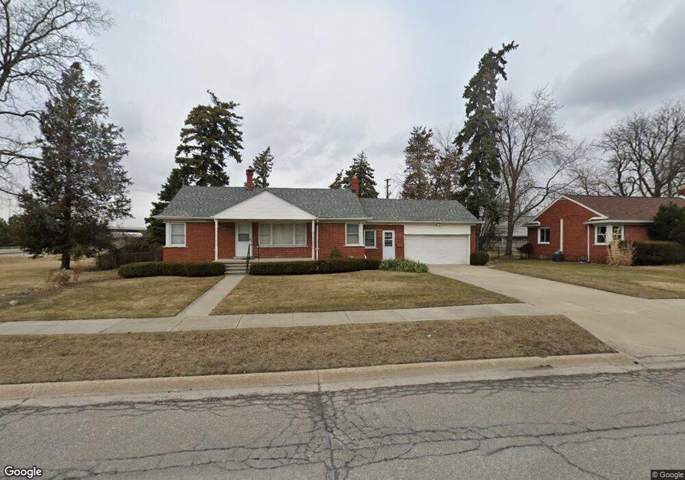
6029 MacKersie Ave Warren, MI 48091
Southwest Warren NeighborhoodEstimated Value: $164,993 - $225,000
Studio
2
Baths
1,228
Sq Ft
$163/Sq Ft
Est. Value
About This Home
This home is located at 6029 MacKersie Ave, Warren, MI 48091 and is currently estimated at $199,748, approximately $162 per square foot. 6029 MacKersie Ave is a home located in Macomb County with nearby schools including Mark C. Roose Elementary School, Wolfe Middle School, and Center Line High School.
Ownership History
Date
Name
Owned For
Owner Type
Purchase Details
Closed on
May 17, 2018
Sold by
Boyd Gail A
Bought by
Andaya Constance M
Current Estimated Value
Purchase Details
Closed on
Aug 8, 2017
Sold by
Andaya Constance M and Boyd Gail A
Bought by
Andaya Constance M
Purchase Details
Closed on
Mar 22, 1991
Sold by
Pohoski Helen and Pohoski Albert
Bought by
Pohoski Helen and Boyd Gail A
Create a Home Valuation Report for This Property
The Home Valuation Report is an in-depth analysis detailing your home's value as well as a comparison with similar homes in the area
Home Values in the Area
Average Home Value in this Area
Purchase History
| Date | Buyer | Sale Price | Title Company |
|---|---|---|---|
| Andaya Constance M | -- | None Available | |
| Andaya Constance M | -- | None Available | |
| Pohoski Helen | -- | None Available |
Source: Public Records
Tax History
| Year | Tax Paid | Tax Assessment Tax Assessment Total Assessment is a certain percentage of the fair market value that is determined by local assessors to be the total taxable value of land and additions on the property. | Land | Improvement |
|---|---|---|---|---|
| 2025 | $2,581 | $90,060 | $0 | $0 |
| 2024 | $25 | $97,640 | $0 | $0 |
| 2023 | $2,457 | $76,550 | $0 | $0 |
| 2022 | $2,375 | $68,370 | $0 | $0 |
| 2021 | $2,416 | $64,830 | $0 | $0 |
| 2020 | $2,355 | $61,920 | $0 | $0 |
| 2019 | $2,311 | $59,800 | $0 | $0 |
| 2018 | $2,317 | $56,390 | $0 | $0 |
| 2017 | $2,203 | $50,010 | $10,430 | $39,580 |
| 2016 | $2,102 | $50,010 | $0 | $0 |
| 2015 | -- | $40,470 | $0 | $0 |
| 2013 | $2,123 | $31,930 | $0 | $0 |
Source: Public Records
Map
Nearby Homes
- 25601 Peter Kaltz Rd
- 5434 Bowden Ct
- 5301 Rene Dr Unit BLDG 27 UNIT 105
- 5441 Stanford Ct Unit 94; Building
- 5442 Stanford Ct
- 25165 Joanne Smith Dr Unit 102
- 6823 Engleman
- 6837 Braun
- 26379 Audrey Ave
- 6838 Braun
- 7250 Voerner Ave
- 7337 Dale
- 26780 Crystal Ave
- 4973 E 10 Mile Rd Unit 8
- 24749 Panama Ave
- 7324 Mckinley
- 24906 Patricia Ave
- 4949 E 10 Mile Rd
- 4925 E 10 Mile Rd Unit 1
- 7377 Bernice
- 6039 MacKersie Ave
- 6024 MacKersie Ave
- 6038 MacKersie Ave
- 6049 MacKersie Ave
- 6002 MacKersie Ave
- 6048 MacKersie Ave
- 6092 MacKersie Ave
- 6101 MacKersie Ave
- 6101 MacKersie Ave
- 25847 Peter Kaltz Rd
- 25821 Peter Kaltz Rd
- 6141 MacKersie Ave
- 25801 Peter Kaltz Rd
- 6160 MacKersie Ave
- 25890 Peter Kaltz Rd
- 25848 Peter Kaltz Rd
- 25771 Peter Kaltz Rd
- 6174 MacKersie Ave
- 6185 MacKersie Ave
- 25822 Peter Kaltz Rd
Your Personal Tour Guide
Ask me questions while you tour the home.