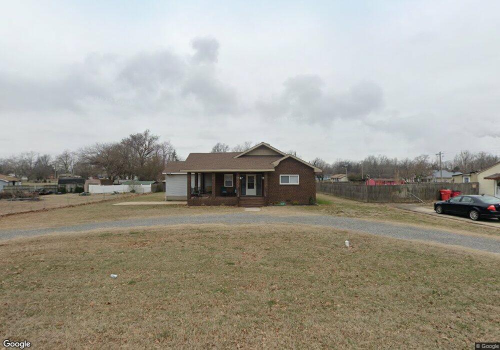
603 Dempster St Sikeston, MO 63801
Estimated Value: $85,000 - $159,000
4
Beds
2
Baths
2,035
Sq Ft
$66/Sq Ft
Est. Value
About This Home
This home is located at 603 Dempster St, Sikeston, MO 63801 and is currently estimated at $133,494, approximately $65 per square foot. 603 Dempster St is a home with nearby schools including Sikeston Senior High School, St. Francis Xavier School, and The Christian Academy.
Ownership History
Date
Name
Owned For
Owner Type
Purchase Details
Closed on
Sep 28, 2021
Sold by
Sloan Ronald and Sloan Mary
Bought by
Conran Capital Llc
Current Estimated Value
Home Financials for this Owner
Home Financials are based on the most recent Mortgage that was taken out on this home.
Original Mortgage
$51,000
Outstanding Balance
$10,778
Interest Rate
2.8%
Mortgage Type
Credit Line Revolving
Estimated Equity
$122,716
Purchase Details
Closed on
Oct 17, 2007
Sold by
Matrix Financial Services Corp
Bought by
Sloan Ronald
Home Financials for this Owner
Home Financials are based on the most recent Mortgage that was taken out on this home.
Original Mortgage
$44,000
Interest Rate
6.37%
Mortgage Type
Purchase Money Mortgage
Create a Home Valuation Report for This Property
The Home Valuation Report is an in-depth analysis detailing your home's value as well as a comparison with similar homes in the area
Home Values in the Area
Average Home Value in this Area
Purchase History
We collect this data history from publicly available records. To have your information removed, we recommend requesting removal directly through your county’s website.
| Date | Buyer | Sale Price | Title Company |
|---|---|---|---|
| Conran Capital Llc | -- | First State Title Svcs Llc | |
| Sloan Ronald | -- | -- |
Source: Public Records
Mortgage History
We collect this data history from publicly available records. To have your information removed, we recommend requesting removal directly through your county’s website.
| Date | Status | Borrower | Loan Amount |
|---|---|---|---|
| Open | Conran Capital Llc | $51,000 | |
| Previous Owner | Sloan Ronald | $44,000 |
Source: Public Records
Tax History
| Year | Tax Paid | Tax Assessment Tax Assessment Total Assessment is a certain percentage of the fair market value that is determined by local assessors to be the total taxable value of land and additions on the property. | Land | Improvement |
|---|---|---|---|---|
| 2025 | $411 | $9,600 | $0 | $0 |
| 2024 | $4 | $8,650 | $0 | $0 |
| 2023 | $410 | $8,650 | $0 | $0 |
| 2022 | $412 | $8,340 | $0 | $0 |
| 2021 | $412 | $8,340 | $0 | $0 |
| 2020 | $369 | $8,020 | $0 | $0 |
| 2019 | -- | $8,020 | $0 | $0 |
| 2018 | -- | $8,020 | $0 | $0 |
| 2017 | -- | $8,020 | $0 | $0 |
| 2014 | -- | $8,020 | $0 | $0 |
| 2011 | -- | $8,020 | $0 | $0 |
Source: Public Records
Map
Nearby Homes
- 1205 W Murray Ln
- 601 Carroll St
- 105 Adams St
- 511 Clayton Ave
- 502 Jaycee St
- 420 Malcolm Ave
- 108 Adams St
- 408 Carroll St
- 520 Coleman St
- 1140 Ruth St
- 1316 Butler St
- 849 William St
- 405 Branum St
- 315 Jackson St
- 848 Agnes St
- 411 S West St
- 617 Daniel St
- 811 Cotton Ridge Dr
- 800 Cotton Ridge Dr
- 810 Cotton Ridge Dr
- 601 Dempster St
- 605 Dempster St
- 1203 W Murray Ln
- 604 Dempster St
- 602 Dempster St
- 1202 Blanton St
- 600 Dempster St
- 606 Dempster St
- 1104 W Murray Ln
- 1106 W Murray Ln
- 1102 W Murray Ln
- 608 Dempster St
- 1108 W Murray Ln
- 1100 W Murray Ln
- 1141 W Murray Ln
- 609 Dempster St
- 1300 W Murray Ln
- 1209 W Murray Ln
- 525 Malcolm Ave
- 512 John R Blvd
Your Personal Tour Guide
Ask me questions while you tour the home.