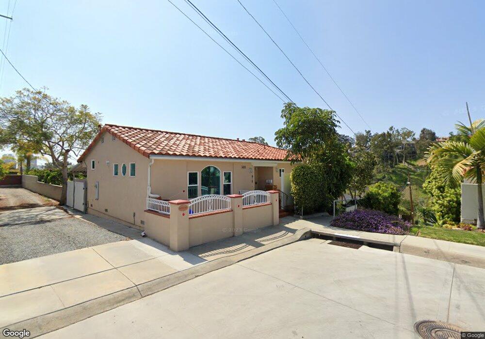
603 W Palm St San Diego, CA 92103
Bankers Hill NeighborhoodEstimated Value: $1,296,928 - $2,010,000
3
Beds
2
Baths
1,765
Sq Ft
$907/Sq Ft
Est. Value
About This Home
This home is located at 603 W Palm St, San Diego, CA 92103 and is currently estimated at $1,599,982, approximately $906 per square foot. 603 W Palm St is a home located in San Diego County with nearby schools including Florence Elementary School, Roosevelt International Middle School, and Museum School.
Ownership History
Date
Name
Owned For
Owner Type
Purchase Details
Closed on
Dec 3, 2014
Sold by
Deluca Steven G and De Luca Silvester G
Bought by
Deluca Steven G
Current Estimated Value
Home Financials for this Owner
Home Financials are based on the most recent Mortgage that was taken out on this home.
Original Mortgage
$294,000
Interest Rate
3%
Mortgage Type
Adjustable Rate Mortgage/ARM
Purchase Details
Closed on
Nov 1, 1996
Sold by
Deluca Silvester G
Bought by
Deluca Silvester G
Purchase Details
Closed on
Sep 19, 1996
Sold by
Davis Gerald H and Deluca Rosalia
Bought by
Deluca Silvester G
Create a Home Valuation Report for This Property
The Home Valuation Report is an in-depth analysis detailing your home's value as well as a comparison with similar homes in the area
Home Values in the Area
Average Home Value in this Area
Purchase History
| Date | Buyer | Sale Price | Title Company |
|---|---|---|---|
| Deluca Steven G | -- | First American Title Company | |
| Deluca Silvester G | -- | Chicago Title Company | |
| Deluca Silvester G | -- | Chicago Title Co |
Source: Public Records
Mortgage History
| Date | Status | Borrower | Loan Amount |
|---|---|---|---|
| Closed | Deluca Steven G | $294,000 |
Source: Public Records
Tax History Compared to Growth
Tax History
| Year | Tax Paid | Tax Assessment Tax Assessment Total Assessment is a certain percentage of the fair market value that is determined by local assessors to be the total taxable value of land and additions on the property. | Land | Improvement |
|---|---|---|---|---|
| 2025 | $1,874 | $159,901 | $49,865 | $110,036 |
| 2024 | $1,874 | $156,767 | $48,888 | $107,879 |
| 2023 | $1,831 | $153,694 | $47,930 | $105,764 |
| 2022 | $1,781 | $150,682 | $46,991 | $103,691 |
| 2021 | $1,767 | $147,728 | $46,070 | $101,658 |
| 2020 | $1,745 | $146,214 | $45,598 | $100,616 |
| 2019 | $1,713 | $143,348 | $44,704 | $98,644 |
| 2018 | $1,601 | $140,538 | $43,828 | $96,710 |
| 2017 | $80 | $137,783 | $42,969 | $94,814 |
| 2016 | $1,534 | $135,082 | $42,127 | $92,955 |
| 2015 | $1,510 | $133,054 | $41,495 | $91,559 |
| 2014 | $1,486 | $130,449 | $40,683 | $89,766 |
Source: Public Records
Map
Nearby Homes
- 2805 State St
- 2948-54 Reynard Way
- 2730 Brant St
- 405 W Nutmeg St
- 2861 Brant St
- 2871 Brant St
- 2715 Columbia St
- 2854 Albatross St
- 0 Reynard Way Unit PTP2505859
- 2930 Columbia St Unit F
- 1034 W Quince St
- 450 W Laurel St
- 2630 Front St
- 3025-37 Columbia St
- 2453 Curlew St
- 1295 W Redwood St
- 230 W Laurel St Unit 601
- 230 W Laurel St Unit 506
- 2445 Brant St Unit 612
- 2445 Brant St Unit 613