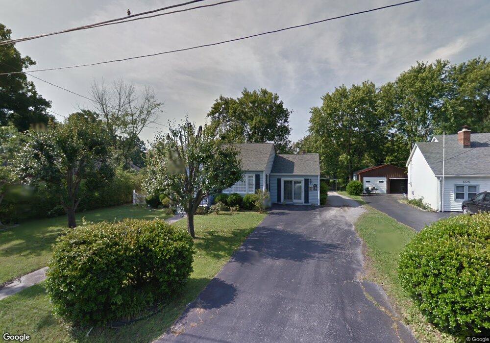
604 Martin Ave Lebanon, TN 37087
Estimated Value: $261,196 - $324,000
--
Bed
1
Bath
1,451
Sq Ft
$203/Sq Ft
Est. Value
About This Home
This home is located at 604 Martin Ave, Lebanon, TN 37087 and is currently estimated at $294,799, approximately $203 per square foot. 604 Martin Ave is a home located in Wilson County with nearby schools including Byars Dowdy Elementary School, Winfree Bryant Middle School, and Lebanon High School.
Ownership History
Date
Name
Owned For
Owner Type
Purchase Details
Closed on
Sep 29, 2010
Sold by
Oulliber Lisa M
Bought by
Oulliber Lynne M
Current Estimated Value
Home Financials for this Owner
Home Financials are based on the most recent Mortgage that was taken out on this home.
Original Mortgage
$63,500
Outstanding Balance
$480
Interest Rate
4.36%
Estimated Equity
$294,320
Purchase Details
Closed on
Jul 1, 1998
Sold by
Hanson Paul A and Hanson Wanda F
Bought by
Oulliber Lynne M and Oulliber Lisa M
Purchase Details
Closed on
Apr 4, 1904
Bought by
Hanson Paul A and Hanson Wanda F
Create a Home Valuation Report for This Property
The Home Valuation Report is an in-depth analysis detailing your home's value as well as a comparison with similar homes in the area
Home Values in the Area
Average Home Value in this Area
Purchase History
| Date | Buyer | Sale Price | Title Company |
|---|---|---|---|
| Oulliber Lynne M | -- | -- | |
| Oulliber Lynne M | $90,000 | -- | |
| Hanson Paul A | -- | -- |
Source: Public Records
Mortgage History
| Date | Status | Borrower | Loan Amount |
|---|---|---|---|
| Open | Hanson Paul A | $63,500 |
Source: Public Records
Tax History Compared to Growth
Tax History
| Year | Tax Paid | Tax Assessment Tax Assessment Total Assessment is a certain percentage of the fair market value that is determined by local assessors to be the total taxable value of land and additions on the property. | Land | Improvement |
|---|---|---|---|---|
| 2024 | $952 | $43,175 | $18,750 | $24,425 |
| 2022 | $1,249 | $43,200 | $18,750 | $24,450 |
| 2021 | $1,249 | $43,200 | $18,750 | $24,450 |
| 2020 | $1,030 | $43,200 | $18,750 | $24,450 |
| 2019 | $235 | $27,375 | $9,250 | $18,125 |
| 2018 | $961 | $27,375 | $9,250 | $18,125 |
| 2017 | $961 | $27,375 | $9,250 | $18,125 |
| 2016 | $961 | $27,375 | $9,250 | $18,125 |
| 2015 | $993 | $27,375 | $9,250 | $18,125 |
| 2014 | $758 | $20,900 | $0 | $0 |
Source: Public Records
Map
Nearby Homes
- 509 B Castle Heights Ave
- 305 Castle Heights Ave
- 438 Leeville Pike
- 421 Hobbs Ave
- 619 W Spring St
- 604 Pennsylvania Annex
- 713 Kent Dr
- 715 Kent Dr
- 715 Fields Ln
- 717 Kent Dr
- 719 Kent Dr
- 721 Kent Dr
- 313 Hobbs Ave
- 908 Long Leaf Rd
- 220 Cumberland Dr
- 521 S Maple St
- 127 S Greenwood St
- 319 June Dr
- 408 Dawson Ln
- 123 High Park Cir
- 606 Martin Ave
- 400 Pennsylvania Ave
- 603 Martin Ave
- 608 Martin Ave
- 404 Pennsylvania Ave
- 314 Pennsylvania Ave
- 615 Moody Ct
- 615 Moody Ct Unit B
- 615 Moody Ct Unit A
- 312 Pennsylvania Ave
- 610 Martin Ave
- 401 Pennsylvania Ave
- 403 Pennsylvania Ave
- 605 Martin Ave
- 406 Pennsylvania Ave
- 607 Moody Ct
- 607 Moody Ct Unit B
- 308 Pennsylvania Ave
- 313 Pennsylvania Ave
- 612 Martin Ave