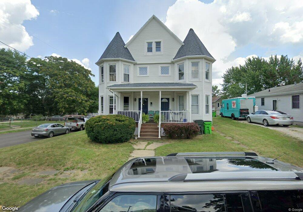
604 S Seneca Ave Alliance, OH 44601
Estimated Value: $14,455 - $113,000
6
Beds
2
Baths
2,608
Sq Ft
$31/Sq Ft
Est. Value
About This Home
This home is located at 604 S Seneca Ave, Alliance, OH 44601 and is currently estimated at $80,114, approximately $30 per square foot. 604 S Seneca Ave is a home located in Stark County with nearby schools including Alliance Intermediate School at Northside, Alliance Elementary School at Rockhill, and Alliance Middle School.
Ownership History
Date
Name
Owned For
Owner Type
Purchase Details
Closed on
May 13, 2011
Sold by
Casas Coast Llc
Bought by
Moonbeam Properties Llc
Current Estimated Value
Purchase Details
Closed on
Sep 30, 2009
Sold by
R R Estates Llc
Bought by
Casas Coast Llc
Purchase Details
Closed on
Sep 1, 2007
Sold by
Ghattas Reemon
Bought by
R R Estates Llc
Purchase Details
Closed on
Jul 2, 2007
Sold by
Um Capital Llc
Bought by
Ghattas Reemon
Purchase Details
Closed on
Mar 21, 2007
Sold by
Barth C Andrew and Peet Joy L
Bought by
Um Capital Llc
Purchase Details
Closed on
Nov 17, 1992
Create a Home Valuation Report for This Property
The Home Valuation Report is an in-depth analysis detailing your home's value as well as a comparison with similar homes in the area
Home Values in the Area
Average Home Value in this Area
Purchase History
| Date | Buyer | Sale Price | Title Company |
|---|---|---|---|
| Moonbeam Properties Llc | $6,000 | Attorney | |
| Casas Coast Llc | $16,600 | Attorney | |
| R R Estates Llc | $15,100 | Attorney | |
| Ghattas Reemon | $7,000 | Nova Title Agency Inc | |
| Um Capital Llc | $32,000 | None Available | |
| -- | $5,000 | -- |
Source: Public Records
Tax History
| Year | Tax Paid | Tax Assessment Tax Assessment Total Assessment is a certain percentage of the fair market value that is determined by local assessors to be the total taxable value of land and additions on the property. | Land | Improvement |
|---|---|---|---|---|
| 2025 | -- | $12,330 | $3,680 | $8,650 |
| 2024 | -- | $18,450 | $3,680 | $14,770 |
| 2023 | $353 | $8,580 | $1,890 | $6,690 |
| 2022 | $331 | $7,980 | $1,890 | $6,090 |
| 2021 | $332 | $7,980 | $1,890 | $6,090 |
| 2020 | $387 | $8,690 | $1,650 | $7,040 |
| 2019 | $381 | $8,690 | $1,650 | $7,040 |
Source: Public Records
Map
Nearby Homes
- 442 S Liberty Ave
- 452 E Summit St
- V/L S Freedom Ave
- 955 E Summit St
- 726 S Arch Ave
- 935 S Morgan Ave
- 234 Rosenberry St
- 231 Rosenberry St
- 361 E Main St
- 226 Milner St
- 62 E High St
- 0 E Oxford St
- 847 E Patterson St
- 46 Rosenberry St
- 427 S Union Ave
- 167 11th St
- 134 11th St
- 807 S Union Ave
- 62 E Market St
- 1350 S Freedom Ave
- 616 S Seneca Ave
- 548 S Seneca Ave
- 628 S Seneca Ave
- 617 S Liberty Ave
- 536 S Seneca Ave
- 625 S Liberty Ave
- 625 S Liberty Ave
- 549 S Liberty Ave
- 638 S Seneca Ave
- 533 E Cambridge St
- 543 S Seneca Ave
- 627 S Seneca Ave
- 627 S Liberty Ave
- 46163 E Cambridge St
- 648 S Seneca Ave
- 531 S Seneca Ave
- 536 E Cambridge St
- 656 S Seneca Ave
- 612 S Liberty Ave
- 521 S Seneca Ave
Your Personal Tour Guide
Ask me questions while you tour the home.