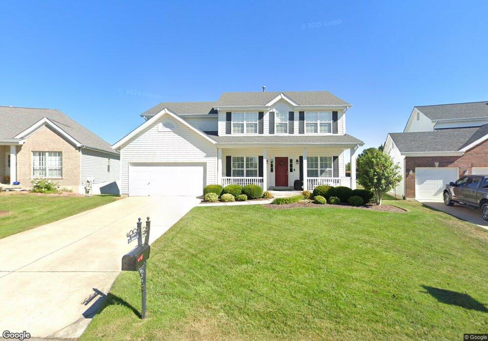
604 Thornridge Dr O Fallon, MO 63368
Estimated Value: $467,169 - $505,000
4
Beds
3
Baths
2,620
Sq Ft
$188/Sq Ft
Est. Value
About This Home
This home is located at 604 Thornridge Dr, O Fallon, MO 63368 and is currently estimated at $493,292, approximately $188 per square foot. 604 Thornridge Dr is a home located in St. Charles County with nearby schools including Crossroads Elementary School, Frontier Middle School, and Liberty High School.
Ownership History
Date
Name
Owned For
Owner Type
Purchase Details
Closed on
Sep 11, 2014
Sold by
Bridgeforth William J and Bridgeforth Janet E
Bought by
Bridgeforth Family Trust
Current Estimated Value
Purchase Details
Closed on
Dec 13, 2000
Sold by
Mcbride & Son Homes Inc
Bought by
Bridgeforth William J and Bridgeforth Janet B
Home Financials for this Owner
Home Financials are based on the most recent Mortgage that was taken out on this home.
Original Mortgage
$145,000
Interest Rate
7.72%
Create a Home Valuation Report for This Property
The Home Valuation Report is an in-depth analysis detailing your home's value as well as a comparison with similar homes in the area
Home Values in the Area
Average Home Value in this Area
Purchase History
| Date | Buyer | Sale Price | Title Company |
|---|---|---|---|
| Bridgeforth Family Trust | -- | None Available | |
| Bridgeforth William J | $234,175 | -- |
Source: Public Records
Mortgage History
| Date | Status | Borrower | Loan Amount |
|---|---|---|---|
| Closed | Bridgeforth William J | $145,000 |
Source: Public Records
Tax History
| Year | Tax Paid | Tax Assessment Tax Assessment Total Assessment is a certain percentage of the fair market value that is determined by local assessors to be the total taxable value of land and additions on the property. | Land | Improvement |
|---|---|---|---|---|
| 2025 | $5,303 | $83,955 | -- | -- |
| 2023 | $5,308 | $77,610 | $0 | $0 |
| 2022 | $5,009 | $68,293 | $0 | $0 |
| 2021 | $5,020 | $68,293 | $0 | $0 |
| 2020 | $4,537 | $59,262 | $0 | $0 |
| 2019 | $4,258 | $59,262 | $0 | $0 |
| 2018 | $4,267 | $56,505 | $0 | $0 |
| 2017 | $4,240 | $56,505 | $0 | $0 |
| 2016 | $4,118 | $52,632 | $0 | $0 |
| 2015 | $4,057 | $52,632 | $0 | $0 |
| 2014 | $3,145 | $43,754 | $0 | $0 |
Source: Public Records
Map
Nearby Homes
- 769 Cypress Knoll Dr
- 7839 Town Square Ave
- 7817 Town Square Ave
- 518 Old Dominion St
- 702 Balcarra Dr
- 160 Cedarstone Dr
- 116 Cedarstone Dr
- 112 Wake Forest Place
- 0 Chesapeake @ Cedarstone Unit MAR24063701
- 0 Universal Design @ Cedarstone Unit MAR24063686
- 0 Bridgeport @ Cedarstone Unit MAR24063669
- 0 Braxton @ Cedarstone Unit MAR24063663
- 0 Lancaster @ Cedarstone Unit MAR24063683
- 0 Pierce @ Cedarstone Unit MAR24063672
- 0 Rosemont @ Cedarstone Unit MAR24063677
- 0 Portsmouth @ Cedarstone Unit MAR24063654
- 0 Sierra @ Cedarstone Unit MAR24063703
- 624 Hawk Run Dr
- 2570 Technology Dr
- 131 Wake Forest Place
- 606 Thornridge Dr
- 602 Thornridge Dr
- 608 Thornridge Dr
- 610 Thornridge Dr
- 609 Thornridge Dr
- 202 Chestnut Hill Dr
- 103 Timber Meadows Dr
- 1 Chestnut Hill Ct
- 611 Thornridge Dr
- 204 Chestnut Hill Dr
- 3 Chestnut Hill Ct
- 102 Timber Meadows Dr
- 614 Thornridge Dr
- 613 Thornridge Dr
- 302 Copper Tree Ct
- 105 Timber Meadows Dr
- 206 Chestnut Hill Dr
- 5 Chestnut Hill Ct
- 615 Thornridge Dr
- 304 Copper Tree Ct
Your Personal Tour Guide
Ask me questions while you tour the home.