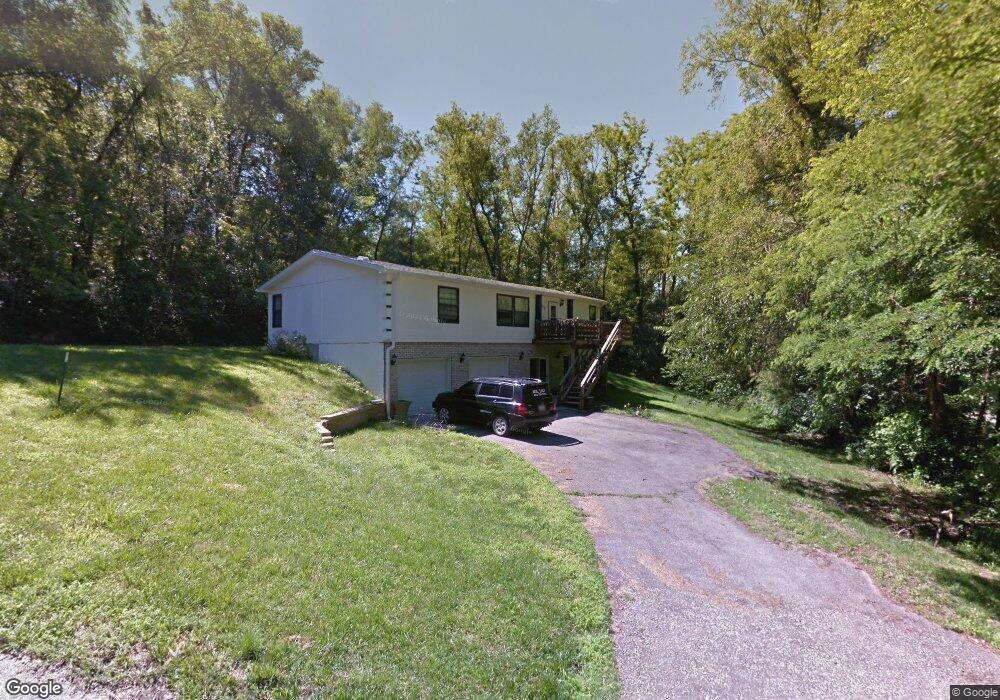
605 E May St Crescent, IA 51526
Estimated Value: $151,000 - $265,000
3
Beds
2
Baths
1,404
Sq Ft
$145/Sq Ft
Est. Value
About This Home
This home is located at 605 E May St, Crescent, IA 51526 and is currently estimated at $203,031, approximately $144 per square foot. 605 E May St is a home located in Pottawattamie County with nearby schools including Lewis & Clark Elementary School, Gerald W. Kirn Middle School, and Abraham Lincoln High School.
Ownership History
Date
Name
Owned For
Owner Type
Purchase Details
Closed on
Apr 8, 2022
Sold by
Flott Barbara J and Collins Barbara J
Bought by
Collins Dennis L
Current Estimated Value
Purchase Details
Closed on
Mar 31, 2022
Sold by
Dennis Collins
Bought by
Collins Barbara
Purchase Details
Closed on
Feb 11, 2016
Sold by
Collins Dennis and Collins Barbara
Bought by
Perdue Darrell and Perdue Nena
Create a Home Valuation Report for This Property
The Home Valuation Report is an in-depth analysis detailing your home's value as well as a comparison with similar homes in the area
Purchase History
| Date | Buyer | Sale Price | Title Company |
|---|---|---|---|
| Collins Dennis L | $150,000 | None Listed On Document | |
| Collins Barbara | -- | None Listed On Document | |
| Perdue Darrell | $140,000 | Attorney |
Source: Public Records
Mortgage History
| Date | Status | Borrower | Loan Amount |
|---|---|---|---|
| Closed | Perdue Darrell | $0 |
Source: Public Records
Tax History
| Year | Tax Paid | Tax Assessment Tax Assessment Total Assessment is a certain percentage of the fair market value that is determined by local assessors to be the total taxable value of land and additions on the property. | Land | Improvement |
|---|---|---|---|---|
| 2025 | $2,672 | $193,700 | $36,600 | $157,100 |
| 2024 | $2,672 | $166,900 | $31,800 | $135,100 |
| 2023 | $2,622 | $166,900 | $31,800 | $135,100 |
| 2022 | $2,796 | $153,600 | $31,800 | $121,800 |
| 2021 | $4,194 | $153,600 | $31,800 | $121,800 |
| 2020 | $2,772 | $144,100 | $28,100 | $116,000 |
| 2019 | $2,442 | $144,100 | $28,100 | $116,000 |
| 2018 | $2,564 | $133,200 | $23,400 | $109,800 |
| 2017 | $2,608 | $133,200 | $23,400 | $109,800 |
| 2015 | $2,694 | $139,963 | $19,880 | $120,083 |
| 2014 | $2,696 | $139,963 | $19,880 | $120,083 |
Source: Public Records
Map
Nearby Homes
- 902 Valley Dr
- 114 Riordan St
- 32 ACRES Old Lincoln Hwy
- 20 ACRES Old Lincoln Hwy
- 1318 Silver Ln
- 1335 Copper Mountain Dr
- 106 Sharon Dr
- 1339 Copper Mountain Dr
- 26366 208th St
- 71.95ACRES Honeysuckle Rd
- 61.50ACRES Honeysuckle Rd
- 111.89 AC 208th St
- 230.36 AC 208th St
- 6.91AC M/L 210th St
- 12C Road L34
- 12A 215th St
- 78 AC M/L Sumac Rd
- 260.84 AC 215th & Pilot Lane St
- 19808 Perry Rd
- 19378 Mudhollow Rd
- 1015 Walnut St
- PAR B May St
- PAR C May St
- .66 ACRES May St
- 1105 Walnut St
- 610 E May St
- 1005 Walnut St
- 1006 Walnut St
- 1104 Walnut St
- 510 Crescent Dr
- 1119 Walnut St
- 418 E Tremont St
- 506 Crescent Dr
- 526 Crescent Dr
- 420 Crescent Dr
- 416 Crescent Dr
- 410 Crescent Dr
- 406 E Tremont St
- 402 E May St
- 517 Crescent Dr
Your Personal Tour Guide
Ask me questions while you tour the home.