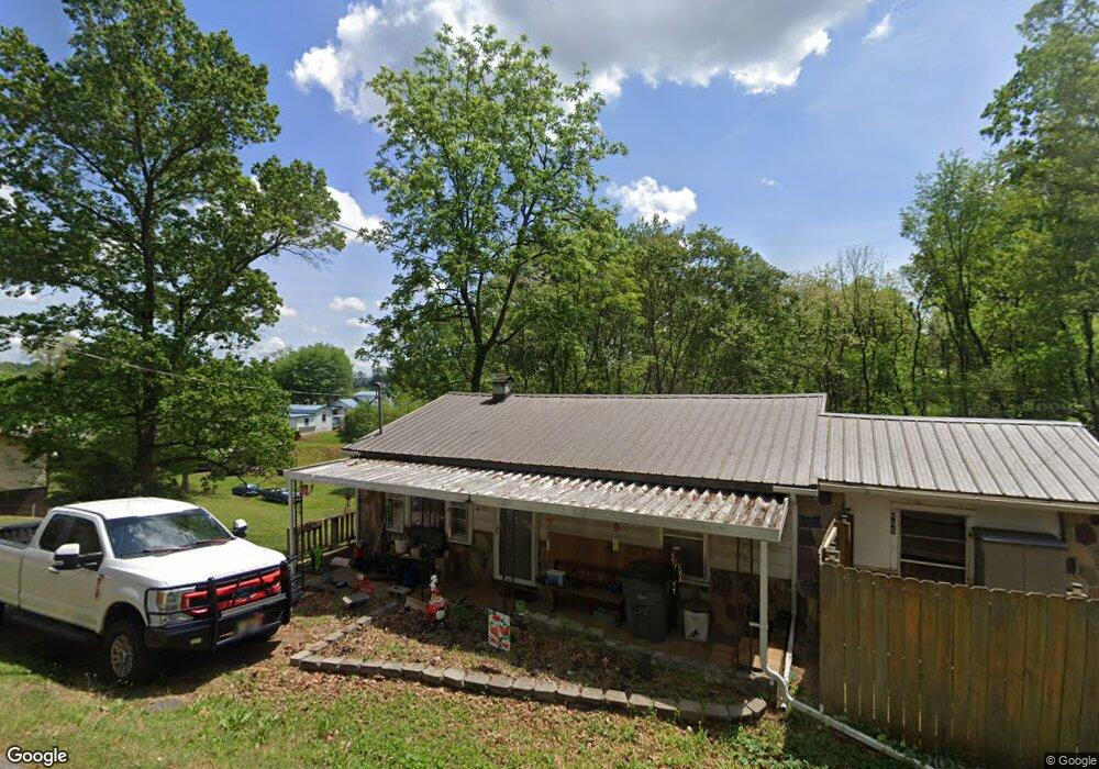
605 Fox Dr Morristown, TN 37814
Estimated Value: $111,421 - $211,000
--
Bed
1
Bath
912
Sq Ft
$199/Sq Ft
Est. Value
About This Home
This home is located at 605 Fox Dr, Morristown, TN 37814 and is currently estimated at $181,605, approximately $199 per square foot. 605 Fox Dr is a home located in Hamblen County with nearby schools including Alpha Elementary School, West View Middle School, and Morristown West High School.
Ownership History
Date
Name
Owned For
Owner Type
Purchase Details
Closed on
Oct 20, 2011
Sold by
Crocker Alice
Bought by
Davis Karla
Current Estimated Value
Purchase Details
Closed on
Jun 30, 2005
Sold by
Williams Clarence G
Bought by
Crocker Alice
Home Financials for this Owner
Home Financials are based on the most recent Mortgage that was taken out on this home.
Original Mortgage
$52,932
Interest Rate
5.57%
Purchase Details
Closed on
Oct 4, 1985
Bought by
Williams Clarence G and Williams Marlene V
Purchase Details
Closed on
Apr 11, 1983
Bought by
Bowlin Sammy and Bowlin Martha
Purchase Details
Closed on
Oct 29, 1974
Bought by
Pritchard Phyllis
Create a Home Valuation Report for This Property
The Home Valuation Report is an in-depth analysis detailing your home's value as well as a comparison with similar homes in the area
Home Values in the Area
Average Home Value in this Area
Purchase History
| Date | Buyer | Sale Price | Title Company |
|---|---|---|---|
| Davis Karla | -- | -- | |
| Crocker Alice | $53,800 | -- | |
| Williams Clarence G | $9,000 | -- | |
| Bowlin Sammy | $14,500 | -- | |
| Pritchard Phyllis | $6,500 | -- |
Source: Public Records
Mortgage History
| Date | Status | Borrower | Loan Amount |
|---|---|---|---|
| Previous Owner | Pritchard Phyllis | $52,932 |
Source: Public Records
Tax History Compared to Growth
Tax History
| Year | Tax Paid | Tax Assessment Tax Assessment Total Assessment is a certain percentage of the fair market value that is determined by local assessors to be the total taxable value of land and additions on the property. | Land | Improvement |
|---|---|---|---|---|
| 2024 | $303 | $15,400 | $5,650 | $9,750 |
| 2023 | $303 | $15,400 | $0 | $0 |
| 2022 | $303 | $15,400 | $5,650 | $9,750 |
| 2021 | $303 | $15,400 | $5,650 | $9,750 |
| 2020 | $303 | $15,400 | $5,650 | $9,750 |
| 2019 | $291 | $13,675 | $6,625 | $7,050 |
| 2018 | $291 | $13,675 | $6,625 | $7,050 |
| 2017 | $291 | $13,675 | $6,625 | $7,050 |
| 2016 | $272 | $13,675 | $6,625 | $7,050 |
| 2015 | $253 | $13,675 | $6,625 | $7,050 |
| 2014 | -- | $13,675 | $6,625 | $7,050 |
| 2013 | -- | $13,900 | $0 | $0 |
Source: Public Records
Map
Nearby Homes
- 430 Fox Dr
- 5715 Academy Dr
- 426 Willow Tree Ln
- 00 Fox Dr
- 738 Bear Springs Rd
- 6005 Shady Grove Rd
- 234 Saint Johns Rd
- 1115 Millrace Rd
- 994 Pinewood Cir
- 640 Pinewood Cir
- 665 Pinewood Cir
- 6163 Silver Fox Trail
- 5203 Cub Cir
- 5130 Old Highway 11e
- 5087 Runnerstone Rd
- 5073 Runnerstone Rd
- 4562 Horseshoe Trail
- 1490 Collinson Ford Rd
- 4537 Horseshoe Trail
- 6262 Wintergreen Rd