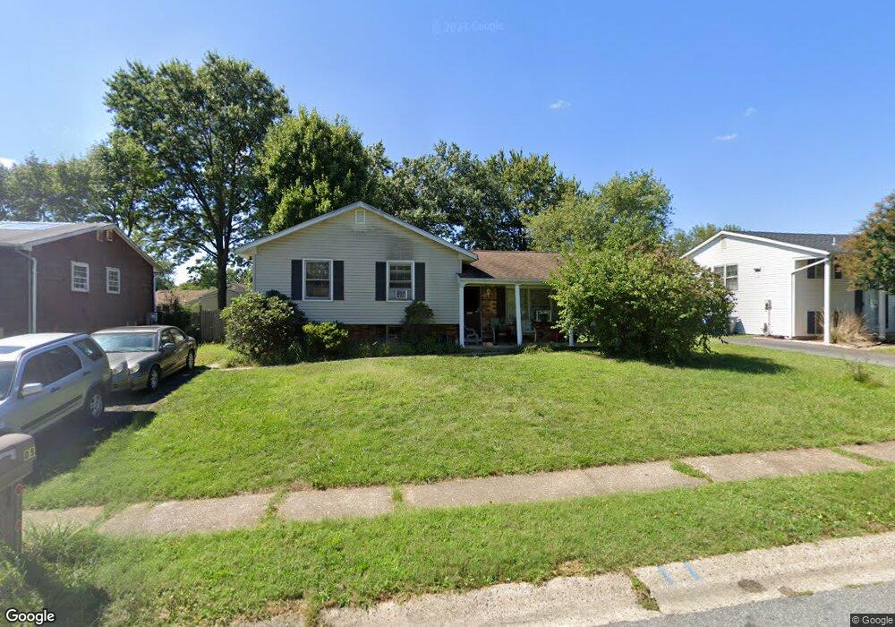
605 Postfield Rd Newark, DE 19713
Estimated Value: $338,967 - $377,000
3
Beds
1
Bath
1,016
Sq Ft
$358/Sq Ft
Est. Value
About This Home
This home is located at 605 Postfield Rd, Newark, DE 19713 and is currently estimated at $363,992, approximately $358 per square foot. 605 Postfield Rd is a home located in New Castle County with nearby schools including Smith (Jennie E.) Elementary School, Gauger-Cobbs Middle School, and Newark High School.
Ownership History
Date
Name
Owned For
Owner Type
Purchase Details
Closed on
Mar 29, 2002
Sold by
Wolfe Mark D and Wolfe Sarah R
Bought by
Draper Simmons Shaunttel C L
Current Estimated Value
Purchase Details
Closed on
Jun 29, 2001
Sold by
Crouse Harold Dean and Roberts Lisa Gay
Bought by
Wolfe Mark D and Wolfe Sarah R
Home Financials for this Owner
Home Financials are based on the most recent Mortgage that was taken out on this home.
Original Mortgage
$118,750
Interest Rate
7.14%
Create a Home Valuation Report for This Property
The Home Valuation Report is an in-depth analysis detailing your home's value as well as a comparison with similar homes in the area
Home Values in the Area
Average Home Value in this Area
Purchase History
| Date | Buyer | Sale Price | Title Company |
|---|---|---|---|
| Draper Simmons Shaunttel C L | $130,500 | -- | |
| Wolfe Mark D | $125,000 | -- |
Source: Public Records
Mortgage History
| Date | Status | Borrower | Loan Amount |
|---|---|---|---|
| Previous Owner | Wolfe Mark D | $118,750 |
Source: Public Records
Tax History
| Year | Tax Paid | Tax Assessment Tax Assessment Total Assessment is a certain percentage of the fair market value that is determined by local assessors to be the total taxable value of land and additions on the property. | Land | Improvement |
|---|---|---|---|---|
| 2024 | $1,138 | $58,400 | $10,600 | $47,800 |
| 2023 | $1,211 | $58,400 | $10,600 | $47,800 |
| 2022 | $1,094 | $58,400 | $10,600 | $47,800 |
| 2021 | $15,770 | $58,400 | $10,600 | $47,800 |
| 2020 | $1,421 | $58,400 | $10,600 | $47,800 |
| 2019 | $1,985 | $58,400 | $10,600 | $47,800 |
| 2018 | $1,111 | $58,400 | $10,600 | $47,800 |
| 2017 | $873 | $58,400 | $10,600 | $47,800 |
| 2016 | $6,099 | $58,400 | $10,600 | $47,800 |
| 2015 | $785 | $58,400 | $10,600 | $47,800 |
| 2014 | $787 | $58,400 | $10,600 | $47,800 |
Source: Public Records
Map
Nearby Homes
- 831 Broadfield Dr
- 886 Broadfield Dr
- 600 Judy Way
- 26 Kensington Ln
- 1202 Pinefield Rd
- 3 Merry Rd
- 21 Kenmar Dr
- 119 Felix Dr
- 11 Kensington Ln
- 148 Brookside Blvd
- 42 Lynch Farm Dr
- 40 E Shady Dr
- 6 Fleming St
- 20 Ardmore Rd
- 17 Pearson Dr
- 11 Carnegie Ct
- 112 Lynch Farm Dr
- 1000 Fountainview Cir Unit 309
- 3000 Fountainview Cir Unit 3411
- 620 Ilse Dr
- 603 Postfield Rd
- 607 Postfield Rd
- 704 Manfield Rd
- 702 Manfield Rd
- 706 Manfield Rd
- 609 Postfield Rd
- 601 Postfield Rd
- 604 Postfield Rd
- 602 Postfield Rd
- 708 Manfield Rd
- 700 Manfield Rd
- 606 Postfield Rd
- 600 Postfield Rd
- 611 Postfield Rd
- 608 Postfield Rd
- 710 Manfield Rd
- 705 Manfield Rd
- 505 Dougfield Rd
- 503 Dougfield Rd
- 613 Postfield Rd
Your Personal Tour Guide
Ask me questions while you tour the home.