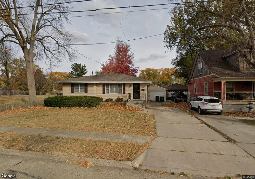
605 SW Des Moines St Ankeny, IA 50023
Southwest Ankeny NeighborhoodEstimated Value: $228,000 - $245,000
3
Beds
1
Bath
1,018
Sq Ft
$232/Sq Ft
Est. Value
About This Home
This home is located at 605 SW Des Moines St, Ankeny, IA 50023 and is currently estimated at $236,354, approximately $232 per square foot. 605 SW Des Moines St is a home located in Polk County with nearby schools including Southview Middle School, Parkview Middle School, and Ankeny High School.
Ownership History
Date
Name
Owned For
Owner Type
Purchase Details
Closed on
Nov 23, 2005
Sold by
Mann Roger F and Mann Monica L
Bought by
Wade Alexander H and Wade Holly L
Current Estimated Value
Home Financials for this Owner
Home Financials are based on the most recent Mortgage that was taken out on this home.
Original Mortgage
$136,500
Outstanding Balance
$72,859
Interest Rate
5.62%
Mortgage Type
Fannie Mae Freddie Mac
Estimated Equity
$163,495
Purchase Details
Closed on
Aug 13, 2002
Sold by
Beauchamp Jamie A and Beauchamp Cathy J
Bought by
Mann Roger and Smith Monica
Home Financials for this Owner
Home Financials are based on the most recent Mortgage that was taken out on this home.
Original Mortgage
$127,000
Interest Rate
6.64%
Create a Home Valuation Report for This Property
The Home Valuation Report is an in-depth analysis detailing your home's value as well as a comparison with similar homes in the area
Home Values in the Area
Average Home Value in this Area
Purchase History
| Date | Buyer | Sale Price | Title Company |
|---|---|---|---|
| Wade Alexander H | $136,500 | Itc | |
| Mann Roger | $127,000 | -- |
Source: Public Records
Mortgage History
| Date | Status | Borrower | Loan Amount |
|---|---|---|---|
| Open | Wade Alexander H | $136,500 | |
| Previous Owner | Mann Roger | $127,000 |
Source: Public Records
Tax History Compared to Growth
Tax History
| Year | Tax Paid | Tax Assessment Tax Assessment Total Assessment is a certain percentage of the fair market value that is determined by local assessors to be the total taxable value of land and additions on the property. | Land | Improvement |
|---|---|---|---|---|
| 2025 | $3,396 | $228,600 | $70,500 | $158,100 |
| 2024 | $3,396 | $209,600 | $63,900 | $145,700 |
| 2023 | $3,374 | $209,600 | $63,900 | $145,700 |
| 2022 | $3,336 | $171,600 | $53,700 | $117,900 |
| 2021 | $3,220 | $171,600 | $53,700 | $117,900 |
| 2020 | $3,176 | $156,700 | $48,900 | $107,800 |
| 2019 | $3,044 | $156,700 | $48,900 | $107,800 |
| 2018 | $3,034 | $143,700 | $44,000 | $99,700 |
| 2017 | $2,916 | $143,700 | $44,000 | $99,700 |
| 2016 | $2,912 | $130,800 | $39,600 | $91,200 |
| 2015 | $2,912 | $130,800 | $39,600 | $91,200 |
| 2014 | $2,808 | $126,500 | $37,700 | $88,800 |
Source: Public Records
Map
Nearby Homes
- 645 SW Kenworthy Dr
- 657 SW Fehn Dr
- 505 SW Ash Dr
- 321 SW Des Moines St
- 3316 NW 27th St
- 13.88 acres Pine Lake Estates Plat 2 St
- 106 NW Scott St
- 1105 SW Des Moines St
- 425 SW State St
- 117 SW Walnut St
- 1109 SW Des Moines St
- 1110 SW Cherry St
- 1203 SW Des Moines St
- 1102 NW 2nd St
- 1207 SW Des Moines St
- 221 NW Scott St
- 1406 NW Pebble Dr
- 1418 NW Pebble Dr
- 1250 SW Magazine Rd Unit 307
- 1250 SW Magazine Rd Unit 310
- 609 SW Des Moines St
- 601 SW Des Moines St
- 613 SW Des Moines St
- 604 SW Elm St
- 531 SW Des Moines St
- 617 SW Des Moines St
- 612 SW Elm St
- 600 SW Elm St
- 606 SW Des Moines St
- 616 SW Elm St
- 602 SW Des Moines St
- 621 SW Des Moines St
- 610 SW Des Moines St
- 534 SW Des Moines St
- 620 SW Elm St
- 618 SW Des Moines St
- 622 SW Des Moines St
- 609 SW Elm St
- 530 SW Des Moines St
- 605 SW Elm St