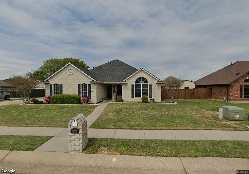
606 Acorn St Pilot Point, TX 76258
Estimated Value: $352,000 - $390,000
4
Beds
2
Baths
1,906
Sq Ft
$194/Sq Ft
Est. Value
About This Home
This home is located at 606 Acorn St, Pilot Point, TX 76258 and is currently estimated at $368,953, approximately $193 per square foot. 606 Acorn St is a home located in Denton County with nearby schools including Pilot Point Early Childhood Center, Pilot Point Elementary School, and Pilot Point Middle School.
Ownership History
Date
Name
Owned For
Owner Type
Purchase Details
Closed on
Oct 7, 2011
Sold by
Suntrust Mortgage Inc
Bought by
Burger Bradley E and Burger Krista E
Current Estimated Value
Home Financials for this Owner
Home Financials are based on the most recent Mortgage that was taken out on this home.
Original Mortgage
$154,209
Outstanding Balance
$107,184
Interest Rate
4.5%
Mortgage Type
FHA
Estimated Equity
$261,769
Purchase Details
Closed on
Aug 15, 2005
Sold by
Erwin Lynette C and Erwin Bobby
Bought by
Suntrust Mortgage
Home Financials for this Owner
Home Financials are based on the most recent Mortgage that was taken out on this home.
Original Mortgage
$116,000
Interest Rate
5.81%
Mortgage Type
Fannie Mae Freddie Mac
Purchase Details
Closed on
Oct 27, 2004
Sold by
Federal Home Loan Mortgage Corporation
Bought by
Shelton Misty K
Home Financials for this Owner
Home Financials are based on the most recent Mortgage that was taken out on this home.
Original Mortgage
$137,738
Interest Rate
5.87%
Mortgage Type
FHA
Purchase Details
Closed on
Feb 25, 2000
Sold by
Cashion R H
Bought by
Mcada Roger D
Home Financials for this Owner
Home Financials are based on the most recent Mortgage that was taken out on this home.
Original Mortgage
$128,150
Interest Rate
8.19%
Create a Home Valuation Report for This Property
The Home Valuation Report is an in-depth analysis detailing your home's value as well as a comparison with similar homes in the area
Home Values in the Area
Average Home Value in this Area
Purchase History
| Date | Buyer | Sale Price | Title Company |
|---|---|---|---|
| Burger Bradley E | -- | Stewart | |
| Suntrust Mortgage | $109,601 | None Available | |
| Erwin Bobby | -- | Fatco | |
| Shelton Misty K | -- | Fatco | |
| Mcada Roger D | -- | -- |
Source: Public Records
Mortgage History
| Date | Status | Borrower | Loan Amount |
|---|---|---|---|
| Open | Burger Bradley E | $154,209 | |
| Previous Owner | Erwin Bobby | $116,000 | |
| Previous Owner | Shelton Misty K | $137,738 | |
| Previous Owner | Mcada Roger D | $128,150 | |
| Closed | Erwin Bobby | $29,000 |
Source: Public Records
Tax History Compared to Growth
Tax History
| Year | Tax Paid | Tax Assessment Tax Assessment Total Assessment is a certain percentage of the fair market value that is determined by local assessors to be the total taxable value of land and additions on the property. | Land | Improvement |
|---|---|---|---|---|
| 2025 | $5,178 | $354,342 | $91,800 | $262,542 |
| 2024 | $6,214 | $345,172 | $0 | $0 |
| 2023 | $4,799 | $313,793 | $91,800 | $295,679 |
| 2022 | $5,865 | $285,266 | $81,000 | $235,613 |
| 2021 | $5,351 | $259,333 | $58,860 | $200,473 |
| 2020 | $5,131 | $246,945 | $58,860 | $188,085 |
| 2019 | $5,042 | $235,374 | $58,860 | $194,296 |
| 2018 | $4,642 | $213,976 | $58,860 | $168,952 |
| 2017 | $4,232 | $194,524 | $46,980 | $159,594 |
| 2016 | $3,847 | $176,840 | $37,800 | $139,040 |
| 2015 | $3,476 | $165,660 | $37,800 | $127,860 |
| 2013 | -- | $152,973 | $37,800 | $115,173 |
Source: Public Records
Map
Nearby Homes
- 600 Acorn St
- 713 E Peel St
- 1702 High Point Dr
- 609 Oak St
- 768 E Northside Dr
- 710 Primrose Ln
- 14120 Marion Downs Trail
- 7723 Bent Gale Rd
- 14106 Marion Downs Trail
- 14085 Ladbroke St
- 14073 Ladbroke St
- 14081 Ladbroke St
- 595 Randys Way
- 108 Dorothy Ct
- 0000 N Washington St
- 545 Minnie Ln
- 584 Boyd Rd
- 597 Mb's Way
- 638 Minnie Ln
- Hanna Plan at Yarbrough Farms