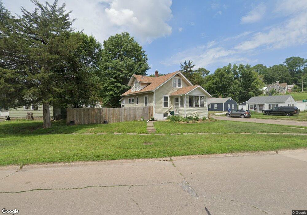
606 Indian Rd Davenport, IA 52802
West End NeighborhoodEstimated Value: $122,000 - $130,000
3
Beds
2
Baths
1,308
Sq Ft
$96/Sq Ft
Est. Value
About This Home
This home is located at 606 Indian Rd, Davenport, IA 52802 and is currently estimated at $125,737, approximately $96 per square foot. 606 Indian Rd is a home located in Scott County with nearby schools including Hayes Elementary School, Frank L. Smart Intermediate School, and West High School.
Ownership History
Date
Name
Owned For
Owner Type
Purchase Details
Closed on
Jan 10, 2022
Sold by
Garrett Dotty A
Bought by
Jenkins Nicollette
Current Estimated Value
Home Financials for this Owner
Home Financials are based on the most recent Mortgage that was taken out on this home.
Original Mortgage
$83,000
Outstanding Balance
$76,495
Interest Rate
3.11%
Mortgage Type
New Conventional
Estimated Equity
$49,242
Purchase Details
Closed on
Mar 5, 2010
Sold by
Swanson Catherine L
Bought by
Bainbridge Dotty A
Home Financials for this Owner
Home Financials are based on the most recent Mortgage that was taken out on this home.
Original Mortgage
$45,600
Interest Rate
5.02%
Mortgage Type
New Conventional
Create a Home Valuation Report for This Property
The Home Valuation Report is an in-depth analysis detailing your home's value as well as a comparison with similar homes in the area
Home Values in the Area
Average Home Value in this Area
Purchase History
| Date | Buyer | Sale Price | Title Company |
|---|---|---|---|
| Jenkins Nicollette | $93,000 | Priester Theodore | |
| Bainbridge Dotty A | -- | None Available | |
| Bainbridge Dotty A | $57,000 | None Available |
Source: Public Records
Mortgage History
| Date | Status | Borrower | Loan Amount |
|---|---|---|---|
| Open | Jenkins Nicollette | $83,000 | |
| Previous Owner | Bainbridge Dotty A | $45,600 |
Source: Public Records
Tax History Compared to Growth
Tax History
| Year | Tax Paid | Tax Assessment Tax Assessment Total Assessment is a certain percentage of the fair market value that is determined by local assessors to be the total taxable value of land and additions on the property. | Land | Improvement |
|---|---|---|---|---|
| 2025 | $1,716 | $107,550 | $15,190 | $92,360 |
| 2024 | $1,674 | $96,010 | $15,190 | $80,820 |
| 2023 | $1,926 | $96,010 | $15,190 | $80,820 |
| 2022 | $1,594 | $90,140 | $13,930 | $76,210 |
| 2021 | $1,594 | $74,300 | $13,930 | $60,370 |
| 2020 | $1,448 | $66,680 | $13,930 | $52,750 |
| 2019 | $1,430 | $63,750 | $13,930 | $49,820 |
| 2018 | $474 | $63,750 | $13,930 | $49,820 |
| 2017 | $355 | $63,750 | $13,930 | $49,820 |
| 2016 | $1,396 | $63,750 | $0 | $0 |
| 2015 | $1,396 | $66,460 | $0 | $0 |
| 2014 | $1,476 | $66,460 | $0 | $0 |
| 2013 | $1,450 | $0 | $0 | $0 |
| 2012 | -- | $65,310 | $12,920 | $52,390 |
Source: Public Records
Map
Nearby Homes
- 3216 Indian Rd
- 3609 Boies Ave
- 3154 Diehn Ave
- 3712 Johnson Ave
- 1109 S Michigan Ave
- 1023 S Elsie Ave
- 1018 S Concord St
- 815 S Dittmer St
- 3631 Homestead Ave
- 3400 Telegraph Rd
- 3011 Telegraph Rd
- 3125 Pearl Ave
- 2736 Rockingham Rd
- 2707 Jackson Ave
- 2614 Mckinley Ave
- 3412 Michigan
- 1515 S Concord St
- 129 S Birchwood Ave
- 2502 Rockingham Rd
- 109 S Birchwood Ave