
Seller's Agent in 2025
Darcy Lawson
The Real Estate Group Inc.
(309) 241-0755
151 Total Sales
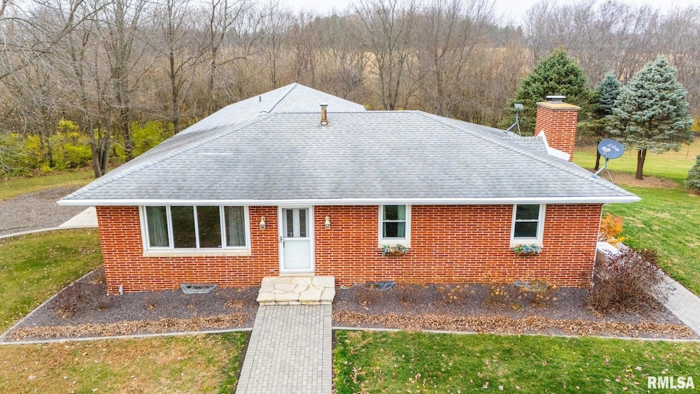

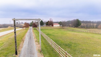

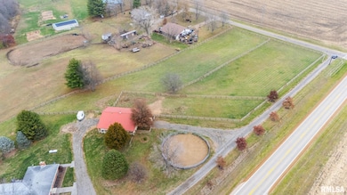
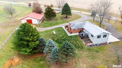
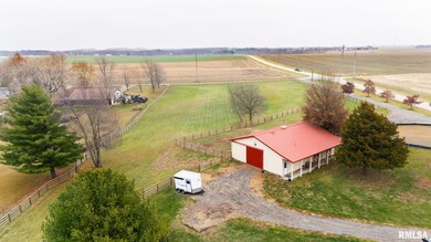
Calling All Horse Lovers!! Beautifully updated ranch with spacious addition, set on 5 acres designed for both comfort and function! The new expansion includes a master bedroom suite, main floor laundry, informal dining area, and a versatile office space — perfect for today’s lifestyle. Step into an incredible kitchen remodel featuring gleaming hardwood floors, quartz countertops, and stainless-steel appliances anchored by a huge walk-in pantry. Designed for entertaining and everyday living, this kitchen is the heart of the home — combining craftsmanship, elegance, and practicality. The finish basement expands your living space. Enjoy entertaining at the bar area, cozy evenings by the fireplace, and the convenience of a full bath. This property features 3 fenced pastures and a 36 x48 horse barn with 4 stalls plus a tack room, perfect for equestrian enthusiasts. A 60 ft pen adds to the versatility for training or recreation. Other amenities include a 3-stall garage with an additional 1-stall workshop for projects or extra storage, whole house generator and deck overlooking property.
Last Agent to Sell the Property
The Real Estate Group Inc. Brokerage Phone: 309-241-0755 License #471.003378 Listed on: 11/23/2025
Last Buyer's Agent
The Real Estate Group Inc. Brokerage Phone: 309-241-0755 License #471.003378 Listed on: 11/23/2025
| Date | Type | Sale Price | Title Company |
|---|---|---|---|
| Warranty Deed | $355,000 | Hometown Title | |
| Warranty Deed | $210,000 | None Available | |
| Warranty Deed | $160,000 | None Available |
| Date | Status | Loan Amount | Loan Type |
|---|---|---|---|
| Previous Owner | $63,000 | Purchase Money Mortgage |
| Date | Event | Price | List to Sale | Price per Sq Ft |
|---|---|---|---|---|
| 12/22/2025 12/22/25 | Sold | $355,000 | +2.9% | $119 / Sq Ft |
| 11/25/2025 11/25/25 | Pending | -- | -- | -- |
| 11/23/2025 11/23/25 | For Sale | $344,900 | -- | $115 / Sq Ft |
| Year | Tax Paid | Tax Assessment Tax Assessment Total Assessment is a certain percentage of the fair market value that is determined by local assessors to be the total taxable value of land and additions on the property. | Land | Improvement |
|---|---|---|---|---|
| 2024 | $3,797 | $58,040 | $5,480 | $52,560 |
| 2023 | $3,797 | $53,400 | $4,970 | $48,430 |
| 2022 | $3,577 | $49,190 | $4,510 | $44,680 |
| 2021 | $3,426 | $47,560 | $4,310 | $43,250 |
| 2020 | $3,442 | $47,530 | $4,280 | $43,250 |
| 2019 | $3,374 | $47,500 | $4,250 | $43,250 |
| 2018 | $3,401 | $47,480 | $4,230 | $43,250 |
| 2017 | $3,388 | $47,040 | $4,000 | $43,040 |
| 2016 | $3,353 | $47,040 | $4,000 | $43,040 |
| 2015 | $2,989 | $0 | $0 | $0 |
| 2013 | $3,184 | $46,510 | $3,960 | $42,550 |
Seller's Agent in 2025
Darcy Lawson
The Real Estate Group Inc.
(309) 241-0755
151 Total Sales
Source: RMLS Alliance
MLS Number: PA1262536
APN: 17-17-25-400-004
Disclaimer: Certain information contained herein is derived from information provided by parties other than Homes.com. All information provided is deemed reliable, but is not guaranteed to be accurate and should be independently verified.
![]() Based on information submitted to the MLS GRID. All data is obtained from various sources and may not have been verified by broker or MLS GRID. Supplied Open House Information is subject to change without notice. All information should be independently reviewed and verified for accuracy. Properties may or may not be listed by the office/agent presenting the information. Some IDX listings have been excluded from this website.IDX information is provided exclusively for personal, non-commercial use, and may not be used for any purpose other than to identify prospective properties consumers may be interested in purchasing. Information is deemed reliable but not guaranteed.
Based on information submitted to the MLS GRID. All data is obtained from various sources and may not have been verified by broker or MLS GRID. Supplied Open House Information is subject to change without notice. All information should be independently reviewed and verified for accuracy. Properties may or may not be listed by the office/agent presenting the information. Some IDX listings have been excluded from this website.IDX information is provided exclusively for personal, non-commercial use, and may not be used for any purpose other than to identify prospective properties consumers may be interested in purchasing. Information is deemed reliable but not guaranteed.
Based on information submitted to the MLS GRID
Ask me questions while you tour the home.