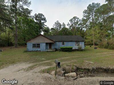
6066 Robinson Cir Naylor, GA 31641
Estimated Value: $63,136 - $303,000
--
Bed
1
Bath
1,768
Sq Ft
$111/Sq Ft
Est. Value
About This Home
This home is located at 6066 Robinson Cir, Naylor, GA 31641 and is currently estimated at $196,034, approximately $110 per square foot. 6066 Robinson Cir is a home located in Lowndes County with nearby schools including Moulton-Branch Elementary School, Pine Grove Middle School, and Lowndes High School.
Ownership History
Date
Name
Owned For
Owner Type
Purchase Details
Closed on
May 8, 2020
Sold by
Mcqueen Earnest
Bought by
Mcqueen Earnest and Wasson Meleade Mcqueen
Current Estimated Value
Purchase Details
Closed on
May 21, 2014
Sold by
Mcqueen Earnest
Bought by
Mcqueen Earnest and Mcqueen Earnestine Marie
Purchase Details
Closed on
Mar 17, 2014
Sold by
Mcqueen Earnest
Bought by
Mcqueen Earnestine Marie
Home Financials for this Owner
Home Financials are based on the most recent Mortgage that was taken out on this home.
Original Mortgage
$165,596
Interest Rate
4.3%
Mortgage Type
New Conventional
Purchase Details
Closed on
Apr 1, 2010
Sold by
Mcqueen Collis Mae
Bought by
Mcqueen Ernest
Purchase Details
Closed on
Mar 22, 1974
Bought by
Mcqueen Earnest and Mcqueen Calli
Create a Home Valuation Report for This Property
The Home Valuation Report is an in-depth analysis detailing your home's value as well as a comparison with similar homes in the area
Home Values in the Area
Average Home Value in this Area
Purchase History
| Date | Buyer | Sale Price | Title Company |
|---|---|---|---|
| Mcqueen Earnest | -- | -- | |
| Mcqueen Earnest | -- | -- | |
| Mcqueen Earnest | -- | -- | |
| Mcqueen Earnestine Marie | -- | -- | |
| Wasson Meleade Mcqueen | -- | -- | |
| Mcqueen Ernest | -- | -- | |
| Mcqueen Earnest | $5,000 | -- |
Source: Public Records
Mortgage History
| Date | Status | Borrower | Loan Amount |
|---|---|---|---|
| Previous Owner | Wasson Meleade Mcqueen | $165,596 | |
| Previous Owner | Mcqueen Ernest | $89,364 |
Source: Public Records
Tax History Compared to Growth
Tax History
| Year | Tax Paid | Tax Assessment Tax Assessment Total Assessment is a certain percentage of the fair market value that is determined by local assessors to be the total taxable value of land and additions on the property. | Land | Improvement |
|---|---|---|---|---|
| 2024 | $418 | $17,520 | $1,138 | $16,382 |
| 2023 | $418 | $16,654 | $1,064 | $15,590 |
| 2022 | $350 | $12,568 | $1,064 | $11,504 |
| 2021 | $366 | $12,568 | $1,064 | $11,504 |
| 2020 | $340 | $12,568 | $1,064 | $11,504 |
| 2019 | $343 | $12,568 | $1,064 | $11,504 |
| 2018 | $71 | $12,568 | $1,064 | $11,504 |
| 2017 | $353 | $12,568 | $1,064 | $11,504 |
| 2016 | $354 | $12,568 | $1,064 | $11,504 |
| 2015 | $339 | $12,568 | $1,064 | $11,504 |
| 2014 | $343 | $12,471 | $967 | $11,504 |
Source: Public Records
Map
Nearby Homes
- 5881 Old State Rd
- 6570 Good Hope Rd
- 6470 Lake Alapaha Blvd
- 6452 Lake Alapaha Blvd
- 6345 Lake Alapaha Blvd
- 6410 Lake Alapaha Blvd
- 6377 Lake Alapaha Blvd
- Lot #41 Natures Way
- 5913 Mariners Way
- 5904 Nature's Way
- 5994 Lake Shore Dr
- 1 Red Oak Point
- 0 Red Oak Point
- 28 River Trail
- LT 95G River Trail
- TBA S Highway 129
- TBD S Highway 129
- TBA Us 129
- 1039 S Highway 129
- TBD Church Rd