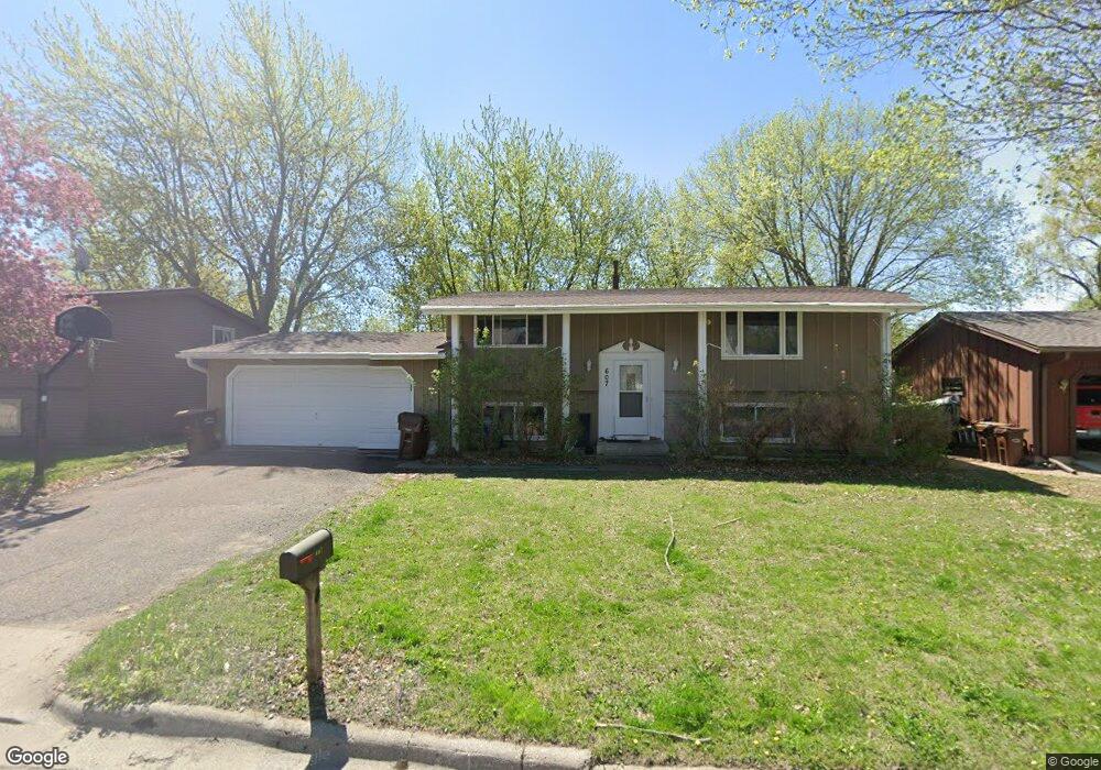
607 Freeman Ave S Delano, MN 55328
Estimated Value: $282,000 - $338,000
4
Beds
2
Baths
908
Sq Ft
$339/Sq Ft
Est. Value
About This Home
This home is located at 607 Freeman Ave S, Delano, MN 55328 and is currently estimated at $307,836, approximately $339 per square foot. 607 Freeman Ave S is a home located in Wright County with nearby schools including Delano Elementary School, Delano Middle School, and Delano Senior High School.
Ownership History
Date
Name
Owned For
Owner Type
Purchase Details
Closed on
May 24, 2017
Sold by
Vervais Christopher T and Vervais Joy M
Bought by
Kurr Samantha and Kurr Paul
Current Estimated Value
Purchase Details
Closed on
Aug 20, 2007
Sold by
Rademacher Daniel M and Rademacher Nicole
Bought by
Vervais Christopher T and Vervais Joy M
Purchase Details
Closed on
Apr 20, 2000
Sold by
Nystrom Herbert W and Nystrom Luella C
Bought by
Rademacher Daniel M and Rademacher Nicole
Create a Home Valuation Report for This Property
The Home Valuation Report is an in-depth analysis detailing your home's value as well as a comparison with similar homes in the area
Home Values in the Area
Average Home Value in this Area
Purchase History
| Date | Buyer | Sale Price | Title Company |
|---|---|---|---|
| Kurr Samantha | $218,500 | None Available | |
| Vervais Christopher T | $213,900 | -- | |
| Rademacher Daniel M | $80,000 | -- |
Source: Public Records
Tax History
| Year | Tax Paid | Tax Assessment Tax Assessment Total Assessment is a certain percentage of the fair market value that is determined by local assessors to be the total taxable value of land and additions on the property. | Land | Improvement |
|---|---|---|---|---|
| 2025 | $3,392 | $286,300 | $60,000 | $226,300 |
| 2024 | $3,380 | $280,200 | $62,000 | $218,200 |
| 2023 | $3,484 | $291,500 | $61,000 | $230,500 |
| 2022 | $3,326 | $275,000 | $61,000 | $214,000 |
| 2021 | $3,234 | $229,400 | $41,000 | $188,400 |
| 2020 | $3,248 | $220,800 | $41,000 | $179,800 |
| 2019 | $3,160 | $211,900 | $0 | $0 |
| 2018 | $2,466 | $199,700 | $0 | $0 |
| 2017 | $2,324 | $151,800 | $0 | $0 |
| 2016 | $2,300 | $0 | $0 | $0 |
| 2015 | $1,792 | $0 | $0 | $0 |
| 2014 | -- | $0 | $0 | $0 |
Source: Public Records
Map
Nearby Homes
- 158 Kings Pointe Dr
- 428 Saint Peter Ave E
- 628 Goldenrod Ct
- 942 Crossing Way
- 955 Crossings Way
- 982 Crossing Way
- 309 4th St S
- 1253 Willowbrook Cir
- 1257 Willowbrook Cir
- 113 3rd St S
- 217 Franklin Ave E
- 124 Oak Ridge Dr
- 737 Elm Ave E
- xxxx Lincoln St
- 1333 Vixen Ln
- 408 2nd St N
- 575 Bonita Cir
- 9560 Us Highway 12
- 679 Marsh Dr
- 9414 U S 12
- 605 Freeman Ave S
- 609 Freeman Ave S
- 603 Freeman Ave S
- 606 Freeman Ave S
- 610 Freeman Ave S
- 608 Freeman Ave S
- 606 Parkview Cir
- 611 1/2 Freeman Ave S
- 611 Freeman Ave S Unit 2 LOWER
- 611 Freeman Ave S
- 611-1/2 Freeman Ave S
- 604 Freeman Ave S
- 767 Rockford Ave E
- 765 Rockford Ave E
- 601 Freeman Ave S
- 763 Rockford Ave E
- 608 Parkview Cir
- 604 Parkview Cir
- 761 Rockford Ave E
- 602 Freeman Ave S
Your Personal Tour Guide
Ask me questions while you tour the home.